Search Results
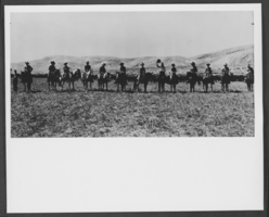
Photograph of Preston Nutter cattle-men on Arizona Strip, Arizona, circa late 1800s - mid 1900s
Date
1870 to 1969
Archival Collection
Description
Description provided with image: "A link between the old West and the new. Preston Nutter cattle-men on the Arizona Strip, the breeding range for the cattle. In the spring steers were shipped to Utah and trailed from the rail head at Colton to the range on the west Tavaputs Plateau."
Image
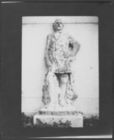
Photograph of a statue of John C. Fremont, Salt Lake City, Utah, circa late 1800s - mid 1900s
Date
1870 to 1969
Archival Collection
Description
A statue of John C. Fremont located at This Is The Place Heritage Park in Salt Lake City, Utah.
Image
Monte-Carlo Casino located in Monaco, two views exterior and interior: photographic prints, approximately 1900 to 1999
Level of Description
Item
Archival Collection
UNLV Libraries Single Item Accession Photograph Collection
To request this item in person:
Collection Number: PH-00171
Collection Name: UNLV Libraries Single Item Accession Photograph Collection
Box/Folder: Flat File 24
Collection Name: UNLV Libraries Single Item Accession Photograph Collection
Box/Folder: Flat File 24
Archival Component
Palmer House, Iroquois Club 19th Annual Jefferson Day Banquet, menu, 1900 April 14
Level of Description
File
Archival Collection
UNLV University Libraries Menu Collection
To request this item in person:
Collection Number: MS-00436
Collection Name: UNLV University Libraries Menu Collection
Box/Folder: Box 106
Collection Name: UNLV University Libraries Menu Collection
Box/Folder: Box 106
Archival Component
New York Central Lines, The Lake Shore Michigan S. Ry. Dining Service, menu, approximately 1900 to 1930
Level of Description
File
Archival Collection
UNLV University Libraries Menu Collection
To request this item in person:
Collection Number: MS-00436
Collection Name: UNLV University Libraries Menu Collection
Box/Folder: Box 107
Collection Name: UNLV University Libraries Menu Collection
Box/Folder: Box 107
Archival Component
"Sinclair [?] Stray Dog Claim, Manhattan District" two men stand next to mining equipment and building, another man is sitting in the distance, Manhattan, Nevada: glass plate negative, approximately 1900 to 1909
Level of Description
Item
Archival Collection
E. W. Smith Glass Plate Negatives
To request this item in person:
Collection Number: PH-00460
Collection Name: E. W. Smith Glass Plate Negatives
Box/Folder: Box 02
Collection Name: E. W. Smith Glass Plate Negatives
Box/Folder: Box 02
Archival Component
A team of horses pull two wagons loaded with lumber and other materials; small homes and mining operation buildings visible in the background, possibly Tonopah, Nevada: glass plate negative, approximately 1900 to 1909
Level of Description
Item
Archival Collection
E. W. Smith Glass Plate Negatives
To request this item in person:
Collection Number: PH-00460
Collection Name: E. W. Smith Glass Plate Negatives
Box/Folder: Box 02
Collection Name: E. W. Smith Glass Plate Negatives
Box/Folder: Box 02
Archival Component

Geologic map of the Lathrop Wells quadrangle, Nye County, Nevada, 1970
Date
1970
Description
58 x 47 cm., on sheet 74 x 84 cm., folded in envelope 30 x 24 cm. Relief shown by contours and spot heights. "Bedrock geology mapped by B.C. Burchfiel, 1961, and by E.J. McKay and K.A. Sargent, 1965-66. Surficial geology mapped by A.T. Fernald, 1968." Includes cross sections, description of map units, and location map. "Prepared in cooperation with the U. S. Atomic Commission." Original publisher: Interior, Geological Survey, Series: Geologic quadrangle map GQ, Scale: 1:24 000.
Image

Geologic map of the Topopah Spring quadrangle, Nye County, Nevada, 1970
Date
1970
Description
58 x 46 cm., on sheet 84 x 88 cm., folded in envelope 30 x 24 cm. Relief shown by contours and spot heights. "Geology mapped in 1962-63." Includes description of map units, colored columnar section, 3 colored cross sections, and quadrangle location map. "Prepared in cooperation with the U. S. Atomic Commission." Original publisher: Interior, Geological Survey, Series: Geologic quadrangle map GQ, Scale: 1:24 000.
Image

Geologic map of the Tippipah Spring quadrangle, Nye County, Nevada, 1963
Date
1963
Description
58 x 46 cm., on sheet 84 x 81 cm., folded in envelope 30 x 24 cm. Relief shown by contours and spot heights. "Geology by P.P. Orkild, 1959-60, paleotopography by D.L. Healey and C.H. Miller, 1959-60." Series statement from envelope. Includes description of map units, 2 col. cross sections, and quadrangle location map. "Prepared in cooperation with the U. S. Atomic Commission." Original publisher: Interior, Geological Survey, Series: Geologic quadrangle map GQ, Scale: 1:24 000.
Image