Search Results
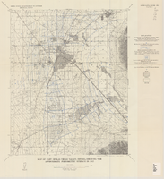
Map of part of Las Vegas Valley, Nevada, showing the approximate piezometric surface in 1912
Date
1965
Description
'Base by U.S. Geological Survey, 1952.' 'Interior--Geological Survey, Washington, D.C.--1965--W63358.' 'Compiled from data published by Carpenter (1915), Kearney (1913), and McWilliams (1913).' Relief shown by contours. Includes township and range lines. Scale 1:62,500 (W 115°15´--W 115°00´/N 36°15´--N 36°00´). Series: Water-supply paper (Washington, D.C.)
1780. Originally published as plate 7 of Available water supply of the Las Vegas ground-water basin, Nevada, by Glenn T. Malmberg, published by the Geological Survey in 1965 as its Water-supply paper 1780.
1780. Originally published as plate 7 of Available water supply of the Las Vegas ground-water basin, Nevada, by Glenn T. Malmberg, published by the Geological Survey in 1965 as its Water-supply paper 1780.
Image
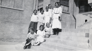
Photograph of girls and a teacher, Las Vegas, Nevada, circa 1910s
Date
1910 to 1919
Archival Collection
Description
Schoolgirls on stairs outside of Methodist Church where school was held in Las Vegas, Nevada. From The young woman holding a book is identified as teacher Florence Doherty.
Image
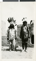
Photograph of Native Americans, Photograph of Pueblo Grande de Nevada, 1926
Date
1926
Archival Collection
Description
Two unidentified, costumed Indians at pageant in Pueblo Grande de Nevada, also known as the "Lost City," near Overton, Nevada. Group Creators credit goes to John W. Walker Electric Studio in Ely, Nevada.
Image
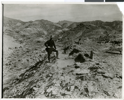
Photograph of Pueblo Grande de Nevada, circa mid to late 1920s
Date
1925 to 1929
Archival Collection
Description
An unidentified archeologist standing by an excavation site at Pueblo Grande de Nevada, also known as "Lost City," near Overton, Nevada. Image may be included in Lost City Album, Nevada State Parks Collection.
Image
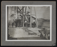
People outside in Goldfield and Tonopah, Nevada: photographic prints, image 002
Description
From the Nevada Mining Photograph Collection (PH-00361) -- People gather around a piece of mining equiptment in Goldfield and Tonopah, Nevada.
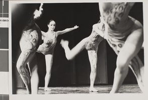
Photograph of Nevada Dance performers, Las Vegas, circa 1970s-1980s
Date
1970 to 1989
Archival Collection
Description
Members of Nevada Dance Theatre performing.
Image
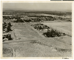
Aerial photograph of North Las Vegas, Nevada, June 5, 1973
Date
1973-06-05
Archival Collection
Description
Aerial view of North Las Vegas, Nevada. Handwritten on back of photograph: "Pecos & Cheyenne, looking south." Hotels in Las Vegas skyline seen in background in upper right.
Image
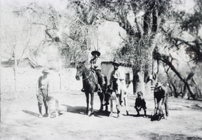
Photograph of men at the Mormon Fort, Las Vegas, Nevada, 1909
Date
1909
Archival Collection
Description
Men and a boy, horses and dogs outside of buildings at the Mormon Fort, Las Vegas, Nevada. Site Name: Las Vegas Mormon Fort (Las Vegas, Nev.)
Image
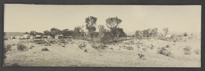
Photograph of a railroad builders' camp, Nevada, circa 1903-1904
Date
1903 to 1904
Archival Collection
Description
A view of a railroad builders' camp for the S.P. (San Pedro), L.A. (Los Angeles) & S.L. (Salt Lake) line between Caliente and Las Vegas in southern Nevada.
Image

Photograph of a bull fence, Panaca, Nevada, circa 1950s-1970s
Date
1950 to 1979
Archival Collection
Description
Description provided with image: "A bull fence, also called a "rip-gut," typical of Meadow Valley and other Western areas prior to the advent of wire in Panaca, Nevada."
Image