Search Results
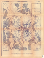
Index map showing locations of geologic sections on plate 2 and wells on plates 2 and 3, Las Vegas Valley, Nevada, 1981 (Open-file report 84-130)
Date
1981
Description
'United States Department of the Interior, Geological Survey. Open-file report 84-130, plate 4.' 'Prepared in cooperation with the Clark County Department of Comprehensive Planning.' 'Base from U.S. Geological Survey 1:100,000 , Boulder City, Ariz.-Nev., Las Vegas, Nev.-Calif., Mesquite Lake, Nev.-Calif., 1978, Lake Mead, Nev.-Ariz., 1979.' Geology from Malmberg (1965); Longwell and others (1965); Bell and Smith (1980); and J. R. Harrill, 1979.' Shows township and range lines. Scale [ca. 1:95.040. 1 in.=approx. 1.5 miles] (W 115°30´--W 115°00´/N 36°30´--N 36°00´). . Series: Open-file report (Geological Survey (U.S.))84-130. Originally published as plate 4 of Ground-water conditions in Las Vegas Valley, Clark County, Nevada. Part I. Hydrogeologic framework / by Russell W. Plume, published by the U.S. Geological Survey in 1984 as Open-file report 84-130.
Image