Search Results
Hughes Aircraft Company under construction, Culver City, California, approximately 1941
Level of Description
File
Archival Collection
Howard Hughes Professional and Aeronautical Photographs
To request this item in person:
Collection Number: PH-00321
Collection Name: Howard Hughes Professional and Aeronautical Photographs
Box/Folder: Folder 08
Collection Name: Howard Hughes Professional and Aeronautical Photographs
Box/Folder: Folder 08
Archival Component
Newspaper clippings about Hughes Aircraft Company in Culver City, 1948-1954
Level of Description
File
Archival Collection
Howard Hughes Public Relations Reference Files
To request this item in person:
Collection Number: MS-00380
Collection Name: Howard Hughes Public Relations Reference Files
Box/Folder: Box 07
Collection Name: Howard Hughes Public Relations Reference Files
Box/Folder: Box 07
Archival Component
Remarks at the dedication of North Las Vegas City Hall, 1966 December 04
Level of Description
File
Archival Collection
Howard Cannon Papers
To request this item in person:
Collection Number: MS-00002
Collection Name: Howard Cannon Papers
Box/Folder: Box 02 (Speeches)
Collection Name: Howard Cannon Papers
Box/Folder: Box 02 (Speeches)
Archival Component
Crosby DeMoss mural at Las Vegas City Hall, approximately 1930-1960
Level of Description
File
Archival Collection
Fred and Maurine Wilson Photograph Collection
To request this item in person:
Collection Number: PH-00014
Collection Name: Fred and Maurine Wilson Photograph Collection
Box/Folder: Folder 05 (Restrictions apply)
Collection Name: Fred and Maurine Wilson Photograph Collection
Box/Folder: Folder 05 (Restrictions apply)
Archival Component
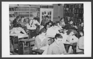
Photograph of students in a study hall/library, Boulder City, Nevada, March 21, 1932
Date
1932-03-21
Archival Collection
Description
Description provided with image: "Combination study hall-library. This is Room 2 shown on the Bureau of Reclamation School Building Plan, No. 45- D1538. March 21, 1932. L-R: Row 1 Ted Lettler, (?), Jones; Row 2: Gene McDonald, Glenn Miller, We Pymm (?), Bob Nellis; Row 4: (?), Glen Nazer, Don Watts, Jim Welsh."
Image
City Hall decorated for Christmas, North Las Vegas, 1961 December 20
Level of Description
File
Archival Collection
North Las Vegas Library Photograph Collection on North Las Vegas, Nevada
To request this item in person:
Collection Number: PH-00277
Collection Name: North Las Vegas Library Photograph Collection on North Las Vegas, Nevada
Box/Folder: Folder 05
Collection Name: North Las Vegas Library Photograph Collection on North Las Vegas, Nevada
Box/Folder: Folder 05
Archival Component
North Las Vegas City Hall and police station, 1964 May 17
Level of Description
File
Archival Collection
North Las Vegas Library Photograph Collection on North Las Vegas, Nevada
To request this item in person:
Collection Number: PH-00277
Collection Name: North Las Vegas Library Photograph Collection on North Las Vegas, Nevada
Box/Folder: Folder 05
Collection Name: North Las Vegas Library Photograph Collection on North Las Vegas, Nevada
Box/Folder: Folder 05
Archival Component
Howard Hughes's HK-1 Hercules in Culver City, California, 1946 June 16
Level of Description
File
Archival Collection
Howard Hughes Public Relations Photograph Collection
To request this item in person:
Collection Number: PH-00373
Collection Name: Howard Hughes Public Relations Photograph Collection
Box/Folder: Folder 20
Collection Name: Howard Hughes Public Relations Photograph Collection
Box/Folder: Folder 20
Archival Component