Search the Special Collections and Archives Portal

Search Results

Display    Results Per Page
Displaying results 75071 - 75080 of 78033

Transcript of interview with Arte Nathan by Claytee White, December 11, 2014

Date

2014-12-11

Description

Arte Nathan is trained in Human Resources. He evolved the thinking in the casino industry to allow management and labor to work for the best interests of both. Educated at Cornell University, he worked with Jim Wilhelm of the Culinary Workers Union Local 226 to develop an unusually profitable relationship that served the casino owner and the people who maintained the cleanliness of the property. “Look, before I got here it was Al Bramlet. I mean the strike of '84 is something that's indelibly etched in all of our minds. The strike in '86 in Atlantic City was much the same. But that type of contentious labor relations is not the future. And there are progressive companies all over the U.S. whether it's General Motors or Ford or Steve Wynn and Mirage Resorts. That's really the story. Are there disconnects along the way? Are there fights and arguments and egos? Of course, there are. But the overriding story of the Culinary Union in Las Vegas between 1980 and 2014 is that they forged a different relationship, a different model that was unique and successful and helped people to live and achieve their dreams. You don't often get that opportunity.” “I'm not the smartest guy in any room. Never have been and I never will be. But I'm willing to try. I'm willing to be open. I have an opinion and I'll fight with my opinion; you fight with yours because two heads are better than one.” He made room for the disabled, ex-felons, and drug addicts. Arte believes that no person is better than another.

Text

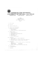
Meeting minutes for Consolidated Student Senate, University of Nevada, Las Vegas, September 30, 1980

Date

1980-09-30

Description

Includes meeting agenda and minutes. CSUN Session 10 Meeting Minutes and Agendas.

Text

Henry and Anita Schuster Papers

Identifier

MS-00580

Abstract

Collection is comprised of correspondence, speeches, essays, meeting minutes, photographs, research materials, publications, press clippings, awards, and event programs (1941-2011) that document the life of Henry Schuster, and his work with his wife Anita. Materials are mainly related to the Holocaust and to Holocaust memory and survivor organizations (especially the Holocaust Survivor's Group of Southern Nevada, which the couple founded, and L’Œuvre de Secours aux Enfants). Genealogical information is also included, as well as records of Henry Schuster’s time in the U.S. Army and his studies at the Manhattan Technical Institute.

Archival Collection

Interview with Melva Jean (Davis) O'Neill, July 2, 2004

Date

2004-07-02

Description

Narrator affiliation: Family Member; Nevada Test Site Historical Foundation

Text

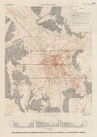
Map and basin profiles showing thickness of valley-fill deposits, Las Vegas Valley, Nevada, 1981 (color variation)

Date

1981

Description

At top of map: 'Department of the Interior. U.S. Geological Survey. Water supply paper2320-A, plate 5.' 'Prepared in cooperation with the Clark County Department of Comprehensive Planning.' At bottom of map: 'Base from U.S. Geological Survey, 1:100,000, Boulder City, Ariz.-Nev., Las Vegas, Nev.-Calif., Mesquite Lake, Nev.-Calif., 1978; Lake Mead, Nev.-Ariz., 1979.' 'Geology from Malmberg (1965); Longwell and others (1965); Haynes (1967); Bell and Smith (1980); Bell (1981) and J. R. Harrill, 1976. Thickness of valley-fill deposits by R.W. Plume, 1981.' Includes three profiles. Shows township and range lines. Scale 1:100.000 (W 115°30´--W 115°00´/N 36°30´--N 36°00´). Series: U.S. Geological Survey water-supply paper, 2320-A. Originally published as plate 5 of Ground-water conditions in Las Vegas Valley, Clark County, Nevada. Part I. Hydrogeologic framework / by Russell W. Plume, published by the U.S. Geological Survey in 1989 as Water-supply paper 2320-A.

Image

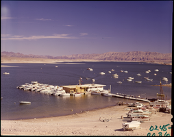
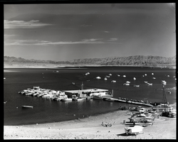
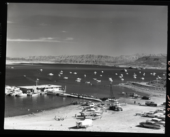
Film transparency of Las Vegas Bay, Lake Mead, Nevada, 1961

Date

1961

Description

Boats are moored at the marina, as well as offshore. Some boats are on the beach, waiting to launch. A few small islands are visible in the background. Las Vegas Bay is a bay at the western edge of Lake Mead, to the northeast of the city of Henderson, Nevada, near the junction of Lake Mead Drive and Lake Mead Boulevard. A public campground and boat access are available in Las Vegas Bay. Low water levels of Lake Mead have rendered the marina there inoperable, and it relocated to the Hemenway Boat Harbor, in the south end of the Boulder Basin in 2002. The launch ramp there has also been closed due to the water levels. The Lake Mead Marina was relocated to the Hemenway Boat Harbor in 2008. The bay is the natural discharge point for the Las Vegas Wash. Las Vegas Wash is in the southeastern portion of the Las Vegas Valley and is approximately 12 miles long, from its headwaters northwest of Las Vegas to its mouth at Las Vegas Bay on the western portion of Lake Mead. The bridge across the Wash on Northshore Road is approximately 1.2 miles north of the intersection of Lakeshore and Northshore Roads.

Image

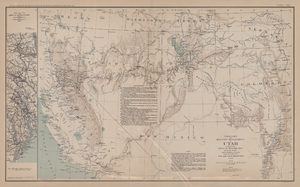
Map of territory and military department of Utah, 1860

Date

1860

Description

Compiled in the Bureau of Topographical Engineers of the War Department. Chiefly for Military purposes under the authority of Honorable J.B. Floyd, Secretary of War, 1860. 42 x 69 cm. Shows towns, wagon roads, explorers' routes, railroads, forts, etc., approx. from Albuquerque, N.M. to Fort Lane, Or. and from Fort Laramie, Wyo. to Los Angeles, Calif. "Corrections and additions in reference to railroads in California, etc., were made in January, 1862 ..." "The new military posts at Fort Bidwell, ... located from a map loaned ... January 16, 1866." "Atlas to accompany the official records of the Union and Confederate armies, 1861-1865. Plate CXX."--Upper margin. Atlas published by the Washington Government Printing Office in 1891-95. Relief shown by hachures. "Julius Bien & Co. Lith. N.Y." Includes text and list of authorities. Inset: March routes of Army of the Tennessee from Savannah, Ga., to Columbia, S.C., 1865, accompanying the report of Maj. Gen O.O. Howard, U.S. Army, series I, vol. XLVII, part I. Includes bibliographical references. Washington Territory is shown prior to becoming Washington state. The geographic region of Southwest is referred to as the New Southwest. Original publisher: Govt. Print. Off..

Image