
Search the Special Collections and Archives Portal

Search Results

Display    Results Per Page
Displaying results 143781 - 143790 of 144269

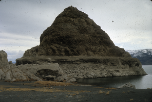
Slide of a tufa deposit in Pyramid Lake, Nevada, circa 1970s

Date

1970 to 1979

Description

The pyramid-shaped island tufa that lies along the east shore of the lake and is the reason the lake was named Pyramid Lake. Pyramid Lake is the geographic sink of the Truckee River Basin, 40 mi (64 km) northeast of Reno. Pyramid Lake is fed by the Truckee River, which is mostly the outflow from Lake Tahoe. The Truckee River enters Pyramid Lake at its southern end. Pyramid Lake has no outlet, with water leaving only by evaporation, or sub-surface seepage (an endorheic lake). The lake has about 10% of the area of the Great Salt Lake, but it has about 25% more volume. The salinity is approximately 1/6 that of sea water. Although clear Lake Tahoe forms the headwaters that drain to Pyramid Lake, the Truckee River delivers more turbid waters to Pyramid Lake after traversing the steep Sierra terrain and collecting moderately high silt-loaded surface runoff. Pyramid Lake is the site of some of the Earth's most spectacular tufa deposits. Tufa is a rock composed of calcium carbonate (CaCO3) that forms at the mouth of a spring, from lake water, or from a mixture of spring and lake water. The explorer John C. Fremont (1845) wrote about the tufas during his 1843-44 expedition and named the lake after the pyramidal-shaped island that lies along the east shore of the lake. The Paiute name for the island is Wono, meaning cone-shaped basket. The Paiute name for the lake is Cui-Ui Panunadu, meaning fish in standing water.

Image

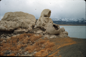
Slide of the rock formation known as The Squaw and Her Basket, Pyramid Lake, Nevada, circa 1970s

Date

1970 to 1979

Description

The rock formation known as The Squaw and Her Basket, Pyramid Lake, Nevada. Pyramid Lake is the geographic sink of the Truckee River Basin, 40 mi (64 km) northeast of Reno. Pyramid Lake is fed by the Truckee River, which is mostly the outflow from Lake Tahoe. The Truckee River enters Pyramid Lake at its southern end. Pyramid Lake has no outlet, with water leaving only by evaporation, or sub-surface seepage (an endorheic lake). The lake has about 10% of the area of the Great Salt Lake, but it has about 25% more volume. The salinity is approximately 1/6 that of sea water. Although clear Lake Tahoe forms the headwaters that drain to Pyramid Lake, the Truckee River delivers more turbid waters to Pyramid Lake after traversing the steep Sierra terrain and collecting moderately high silt-loaded surface runoff. Pyramid Lake is the site of some of the Earth's most spectacular tufa deposits. Tufa is a rock composed of calcium carbonate (CaCO3) that forms at the mouth of a spring, from lake water, or from a mixture of spring and lake water. The explorer John C. Fremont (1845) wrote about the tufas during his 1843-44 expedition and named the lake after the pyramidal-shaped island that lies along the east shore of the lake. The Paiute name for the island is Wono, meaning cone-shaped basket. The Paiute name for the lake is Cui-Ui Panunadu, meaning fish in standing water.

Image

Los Angeles & Salt Lake Railroad Company double privy: architectural drawing

Date

1926-06-14
1927-05-05

Archival Collection

Description

From Union Pacific Railroad Collection (MS-00397). The scales are noted in the drawing. The bottom of the drawing says, "Material-Finish: All Finish Lumber Unless Otherwise Noted Shall Be [Opsas?] Wood Work Of Vault Shall Be O.P Rough. Exterior Of Privy Including Both Sides Of Door And Door Jamb: Also Wood Lattice Screen On All Sides Shall Be Painted With 3 Coats C.S. Lead & Oil Paint As Directed. Doors Shall Be Hung On 3 1/2" x 3 1/2" Botts. Doors Shall Be Provided With Rim Latch Knob Lock And Iron Barrel Bolt. Revisions: Added Vent Stacks, Seat Cover, Double Floor & Floor Shoe". 

The bottom corner of the drawing states, "Union Pacific System L.A. & S.L.R.R. Double Privy 5'x8' With Lattice Screen. Ass't Chief Engineer's Office. Los Angeles, Calif. Drawn By E.C.B. Traced By E.C.B. Checked By F.W.G. Date June 14, 1926. Scale As Noted. Revised May 5. 1927. Drawing No. 15637".

Also written on the drawing: "Two to be built at East Yard, Calif. One ' ' Big Springs, Nev. ' ' Las Vegas, Nev. ' ' Borden, Utah. ' ' Elgin, Nev. 1927. ' ' Dry Lake, Nev. 1927. ' '  Wann ' ' 1928 [crossed out]."

Image

Edgar Flores (Nevada Legislature, Assemblyman) oral history interview conducted by Magdalena Martinez and Facundo Bentancourt: transcript

Date

2022-07-12

Description

From the Lincy Institute "Perspectives from the COVID-19 Pandemic" Oral History Project (MS-01178) -- Elected official interviews file.

Text

Edith Fernandez oral history interview: transcript

Date

2018-09-27

Description

Oral history interview with Edith Fernandez conducted by Marcela Rodriguez-Campo and Claytee D. White on September 27, 2018 for the Latinx Voices of Southern Nevada Oral History Project. In this interview, Fernandez discusses her upbringing in Las Vegas, Nevada and growing up in the Charleston Heights neighborhood. She recalls living in a predominantly white community, and the growth of Latinx families in that area. Fernandez talks about her educational experience in the city, her father's involvement with Culinary Worker Union Local 226, and identifying as a Chicana American. Later, Fernandez remembers her involvement with opening the Cambridge Center, working with the Latino Youth Leadership Conference (LVLC), and becoming the District Director for Representative Steven Horsford. Lastly, Fernandez discusses her role as the Associate Vice President at Nevada State College (NSC).

Text