Search Results
T-Shirt Color: Navy Blue; Front: The City Of Oklahoma City Fire Dept., City Seal; Back: Oklahoma City Fire Rescue; Handwritten Text: To All The Fallen Heroes - Nick & Keeton 607, approximately 2001-2012
Level of Description
File
Archival Collection
New York-New York Hotel and Casino 9-11 Heroes Tribute Collection
To request this item in person:
Collection Number: MS-00459
Collection Name: New York-New York Hotel and Casino 9-11 Heroes Tribute Collection
Box/Folder: Box 183
Collection Name: New York-New York Hotel and Casino 9-11 Heroes Tribute Collection
Box/Folder: Box 183
Archival Component

Map of California and territories of New Mexico and Utah, circa 1861
Date
1856 to 1866
Description
40 x 60 cm. Relief shown by hachures and spot heights. Prime meridians: Greenwich and Washington. Atlas plate numbers 54 and 55 in the upper corners. Shows forts, trails, exploration routes, drainage, mail steamship routes, physical features, Indian tribes, and historic sites. The geographic region of Southwest is referred to as the New Southwest. Original publisher: Johnson .
Image
Clara Bow at 16, after winning the National Fame and Fortune Contest in New York City, New York: photographic print: photographic negative, 1921
Level of Description
Item
Archival Collection
Nan Doughty Photograph Collection
To request this item in person:
Collection Number: PH-00240
Collection Name: Nan Doughty Photograph Collection
Box/Folder: Folder 17
Collection Name: Nan Doughty Photograph Collection
Box/Folder: Folder 17
Archival Component
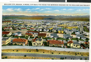
Postcard of Boulder City, circa 1930s-1940s
Date
1930 to 1949
Archival Collection
Description
An artist's color rendering of the Boulder City view towards downtown. Printed text on front of postcard: "Boulder City, Nevada, a model city built to house the workmen engaged on the Boulder Dam project."
Image
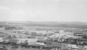
Photograph of Boulder City, Nevada, March 28, 1937
Date
1937-03-28
Archival Collection
Description
The grayscale, aerial view of Boulder City, Nevada. The prominent road of Nevada Way can be seen passing through the little town with the great reservoir of Lake Mead residing in the background.
Image
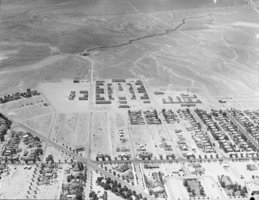
Photograph of Boulder City, Nevada, circa 1933-1934
Date
1932 to 1936
Archival Collection
Description
View of Boulder City, Nevada, showing mostly residential neighborhoods, as well as the Bureau of Reclamation Administration Building (at center left), the Boulder Theatre building on Arizona Street (light-colored building with arches, to the right of the center),and businesses on the Nevada Highway.
Image

Photograph of the Butterfields, Atlantic City (N.J.), October 1954
Date
1954-10
Archival Collection
Description
Georgia and Spencer Butterfield at the American Bankers Association in Atlantic City, New Jersey, October 1954.
Image
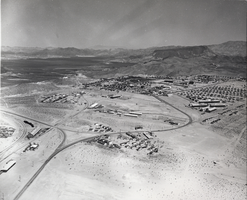
Film transparency of Boulder City, Nevada, circa 1931-1940
Date
1931 to 1940
Archival Collection
Description
An aerial view of Boulder City.
Image
Film transparency of Boulder City, Nevada, circa 1930-1940
Date
1930 to 1940
Archival Collection
Description
An aerial view of Boulder City.
Image
Carson City, Nevada, 1980 to 1989
Level of Description
Series
Scope and Contents
Materials contain photographic slides of neon signs in Carson City, Nevada from 1980 to 1989.
Archival Collection
Neon in Nevada Photograph Collection
To request this item in person:
Collection Number: PH-00225
Collection Name: Neon in Nevada Photograph Collection
Box/Folder: N/A
Collection Name: Neon in Nevada Photograph Collection
Box/Folder: N/A
Archival Component