Search Results

Photograph of the landing of Howard Hughes' Lockheed 14 aircraft, New York, July 14, 1938
Date
1938-07-14
Archival Collection
Description
The black and white, aerial view of Howard Hughes' Lockheed 14 aircraft after performing its final landing on the Round the World flight at Floyd Bennett Airport, New York. Typed onto a piece of paper attached to the image: "Crowd greeting Howard Hughes and crew at floyd Bennett Airport after completing Round-the-World flight."
Image
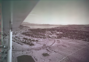
Film transparency of Boulder City, Nevada, and Lake Mead, circa 1931-1936
Date
1931 to 1936
Archival Collection
Description
An image showing an aerial view of Boulder City. The outlines of the small city are distinctively marked by the stark contrast between the city's greenery and the surrounding desert. In the far distance, the shores of Lake Mead can be seen peaking out from behind the mountains. Note: Bits of the airplane from which the image itself was taken can be seen in the upper right corner of the photograph.
Image

Map of California and Territories of New Mexico and Utah, 1862
Date
1862
Description
Scale [ca. 1:3,231,360. 1 in. to approx. 51 miles] (W 125°00--W 103°30/N 42°00--N 31°45) ; 1 map : hand col. ; 40 x 60 cm., on sheet 46 x 68 cm ; Relief indicated by hachures and spot heights ; Prime meridians: Greenwich and Washington, D.C ; Decorative border ; Hand colored ; Atlas p. numbers in upper margin: 58-59 ; Date est. from territorial borders and county configuration ; Shows natural features, locations of Indian tribes, proposed railroad routes, routes of explorers, trails, county boundaries and populated places ; Johnson and Ward
Image
#69825: UNLV graduate Lisa Morris Hibbler poses at Las Vegas City Hall July 31, 2014 in Las Vegas, 2014 July 31
Level of Description
File
Archival Collection
University of Nevada, Las Vegas Creative Services Records (2010s)
To request this item in person:
Collection Number: PH-00388-05
Collection Name: University of Nevada, Las Vegas Creative Services Records (2010s)
Box/Folder: Digital File 00
Collection Name: University of Nevada, Las Vegas Creative Services Records (2010s)
Box/Folder: Digital File 00
Archival Component
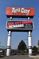
Rail City Casino double mounted sign, Sparks, Nevada
Date
2020
Archival Collection
Description
View of the double mounted sign for Rail City Casino in Sparks during the day with unlit neon.
2121 Victorian Ave, Sparks, NV 89431
Rail City Casino
Image
J. K. Lasser and Co., "Feasibility Study of the Acquisition of the Madison Square Garden Center by the New York City Off-track Betting Corporation", 1975
Level of Description
File
Archival Collection
Eugene Martin Christiansen Papers
To request this item in person:
Collection Number: MS-00561
Collection Name: Eugene Martin Christiansen Papers
Box/Folder: Box 083
Collection Name: Eugene Martin Christiansen Papers
Box/Folder: Box 083
Archival Component
"The New Jersey Experience and the Financial Condition of Atlantic City Casinos" for the University of Nevada Symposium on National and International Trends in Commercial Gaming, 1990
Level of Description
File
Archival Collection
Eugene Martin Christiansen Papers
To request this item in person:
Collection Number: MS-00561
Collection Name: Eugene Martin Christiansen Papers
Box/Folder: Box 049
Collection Name: Eugene Martin Christiansen Papers
Box/Folder: Box 049
Archival Component