Search Results
Las Vegas City Commission Minutes, November 7, 1949 to May 21, 1952
Date
1949-11-07 to 1952-05-21
Archival Collection
Description
Bound volume of Las Vegas City Commission Minutes, November 7, 1949 to May 21, 1952
Text
Las Vegas City Commission Minutes, February 17, 1937 to August 4, 1942
Date
1937-02-17 to 1942-08-04
Archival Collection
Description
Bound volume of Las Vegas City Commission Minutes, February 17, 1937 to August 4, 1942
Text
Las Vegas City Commission Minutes, January 7, 1947 to October 26, 1949
Date
1947-01-07 to 1949-10-26
Archival Collection
Description
Bound volume of Las Vegas City Commission Minutes, January 7, 1947 to October 26, 1949
Text
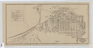
Cadastral map of Boulder City, Nevada, 1940
Date
1905-04-23
Description
A. M. S. Jan. 1940 in the lower left-hand corner. 1 map ; 61 x 30 cm. Cadastral map. "No. 40-1" in the lower right-hand corner. Shows block and lot numbers, buildings, water supply and sewage system, leased areas.
Image
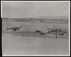
Photograph of an airport, Boulder City (Nev.), March 30, 1937
Date
1937-03-30
Archival Collection
Description
A photograph taken by Rupert B. Spearman of the hub of the Boulder City Airport as seen from the roof of the Grand Canyon Airlines hanger on March 30, 1937. Site Name: Boulder City Municipal Airport (Boulder City, Nev.)
Image
Howard Cannon visits the new Savage Mine at Virginia City, Nevada: photographic print and photographic negative, 1981 January
Level of Description
Item
Archival Collection
Howard Cannon Photograph Collection
To request this item in person:
Collection Number: PH-00192
Collection Name: Howard Cannon Photograph Collection
Box/Folder: Folder 18, Box SH-026
Collection Name: Howard Cannon Photograph Collection
Box/Folder: Folder 18, Box SH-026
Archival Component

Photograph of the Lockheed 14 aircraft, July 1938
Date
1938-07
Archival Collection
Description
The black and white, skyline view of New York City with Lockheed 14 aircraft flying in the foreground. Typed onto script included with the image: "Howard Hughes plane Lockheed 14 in flight over lower New York City. To right in the background can be seen New York City's three bridges of the lower East River from front to rear: the Brooklyn Bridge, Manhattan Bridge, and the Williamsburg Bridge."
Image
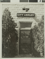
Photograph of Las Vegas City Library, 1943
Date
1943
Archival Collection
Description
The exterior of the Las Vegas City Library in Nevada.
Image
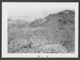
Photograph of Boulder City, Nevada, December 1964
Date
1964-12
Archival Collection
Description
Black and white photograph of mountains in Boulder City.
Image