
Search the Special Collections and Archives Portal

Search Results

Display    Results Per Page
Displaying results 54881 - 54890 of 144079

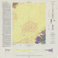
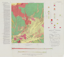
Geologic map of the Frenchman Flat quadrangle, Nye, Lincoln, and Clark Counties, Nevada, 1965

Date

1965

Description

58 x 47 cm., on sheet 81 x 81 cm., folded in envelope 30 x 24 cm. Relief shown by contours and spot heights. "Geology mapped in 1962. Contours on pre-Cenozoic rocks by D. L. Healey and C. H. Miller, 1958-63." Includes text, col. cross section and quadrangle location map. "Prepared in cooperation with the U.S. Atomic Energy Commission." Original publisher: Interior, Geological Survey, Series: Geologic quadrangle map GQ, Scale: 1:24 000.

Image

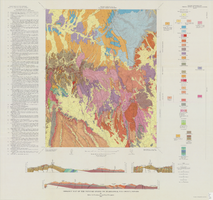
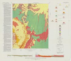
Geologic map of the Topopah Spring NW quadrangle, Nye County, Nevada, 1965

Date

1965

Description

58 x 47 cm., on sheet 84 x 89 cm., folded in envelope 30 x 24 cm. Relief shown by contours and spot heights. "Contour interval 20 feet." "Prepared in cooperation with the U. S. Atomic Energy Commission." "Geology mapped by R. L. Christiansen, P. W. Lipman, and H. R. Cornwall, 1962." Includes text, 3 col. cross sections, and quadrangle location map. Original publisher: Interior, Geological Survey, Series: Geologic quadrangle map GQ, Scale: 1:24 000.

Image

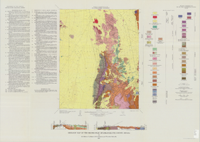
Geologic map of the Belted Peak quadrangle, Nye County, Nevada, 1967

Date

1967

Description

45 x 36 cm., on sheet 64 x 89 cm., fold. in envelope 30 x 24 cm. Relief shown by contours and spot heights. "Contour interval 40 feet." "Prepared in cooperation with the U.S. Atomic Energy Commission." "Geology mapped in 1962-63." Includes text, 2 col. cross sections, and quadrangle location map. Original publisher: U.S. Geological Survey, Series: Geologic quadrangle map GQ, Scale: 1:62 500.

Image

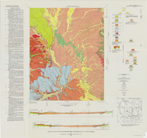
Geologic map of the Buckboard Mesa quadrangle, Nye County, Nevada, 1966

Date

1966

Description

58 x 46 cm., on sheet 87 x 91 cm., folded in envelope 30 x 24 cm. Relief shown by contours and spot heights. "Contour interval 20 feet." "Prepared in cooperation with the U.S. Atomic Energy Commission." "Geology mapped in 1962-63." Includes text, 2 col. cross sections, and 2 index maps. Original publisher: U.S. Geological Survey, Series: Geologic quadrangle map GQ, Scale: 1:24 000.

Image

Geologic map of the Thirsty Canyon quadrangle, Nye County, Nevada, 1966

Date

1966

Description

57 x 46 cm., on sheet 83 x 91 cm., folded in envelope 30 x 24 cm. Relief shown by contours and spot heights. "Geology mapped in 1963." Includes 2 colored cross sections, index map, text, and quadrangle location map. "Prepared in cooperation with the U. S. Atomic Commission." Original publisher: Interior, Geological Survey, Series: Geologic quadrangle map GQ, Scale: 1:24 000.

Image

Geologic map of the Trail Ridge quadrangle, Nye County, Nevada, 1968

Date

1968

Description

58 x 46 cm., on sheet 79 x 91 cm., folded in envelope 30 x 24 cm. Relief shown by contours and spot heights. "Prepared in cooperation with the U.S. Atomic Energy Commission." "Base by U.S. Geological Survey, 1962." "Geology mapped in 1963." "Contour interval 20 feet." Includes text, 2 col. cross sections, quadrangle location map, and 1 index map. Original publisher: Interior, Geological Survey, Series: Geologic quadrangle map GQ, Scale: 1:24 000.

Image

Meeting minutes for Consolidated Student Senate, University of Nevada, Las Vegas, January 09, 2004

Date

2004-01-09

Description

Includes meeting minutes. CSUN Session 34 Meeting Minutes and Agendas.

Text

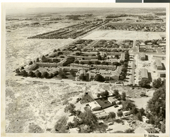
Aerial photograph of apartments and residential neighborhoods in North Las Vegas, Nevada, June 5, 1973

Date

1973-06-05

Description

Aerial view of Northland Gardens apartments, North Las Vegas, Nevada (center of photograph), looking south from Las Vegas Boulevard North. Sandy Lane runs from southwest to northeast through the center of the photograph. Clifford Street appears in the center right. Housing subdivisions are seen in the background. Caption on back of photograph:"Project: Annex. area - land use; Location: Looking so. of LVBN; Remarks: Northland Garden Apt., Hol. PK., Americana."

Image

Evolution of Ivanpah Solar, 2010-2016

Level of Description

Series

Scope and Contents

The Evolution of Ivanapah Solar series (2010-2014) is comprised of 300 digital photographs that represent Jamey Stillings's work on

render="italic">The Evolution of Ivanpah Solar

, a photography project about the construction of the Ivanpah Solar Electric Generating System located along the Nevada and California border. The majority of the images are taken from an aerial perspective and are black-and-white. Some color photographs are included.

Archival Collection

Jamey Stillings Photograph Collection
To request this item in person:
Collection Number: PH-00380
Collection Name: Jamey Stillings Photograph Collection
Box/Folder: N/A

Archival Component

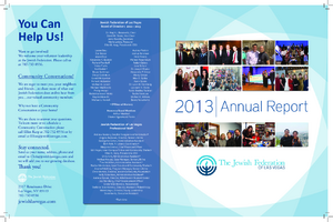
Annual Report of the Jewish Federation of Las Vegas, 2013

Date

2013

Archival Collection

Description

Annual report from the Jewish Federation of Las Vegas for 2013.

Text