Search Results
Negative: Oran K. Gragson in his office at City Hall, 1961 December 21
Level of Description
File
Archival Collection
Oran K. Gragson Photographs
To request this item in person:
Collection Number: PH-00310
Collection Name: Oran K. Gragson Photographs
Box/Folder: Box SH-032
Collection Name: Oran K. Gragson Photographs
Box/Folder: Box SH-032
Archival Component
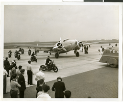
Photograph of Howard Hughes in New York, July 14, 1938
Date
1938-07-14
Archival Collection
Description
Typed onto a piece of paper attached to the image: "Scene at Floyd Bennett Field as Howard Hughes and his crew landed after completing a round the world hop. 7-14-38. (Press Association)."
Image
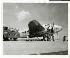
Photograph of mechanics with the Lockheed 14 aircraft, New York, July 10, 1938
Date
1938-07-10
Archival Collection
Description
The black and white view of a plane used by Howard Hughes being fueled up at Floyd Bennett Field in New York.
Image
Remarks at the dedication of North Las Vegas City Hall, 1966 December 04
Level of Description
File
Archival Collection
Howard Cannon Papers
To request this item in person:
Collection Number: MS-00002
Collection Name: Howard Cannon Papers
Box/Folder: Box 02 (Speeches)
Collection Name: Howard Cannon Papers
Box/Folder: Box 02 (Speeches)
Archival Component
Crosby DeMoss mural at Las Vegas City Hall, approximately 1930-1960
Level of Description
File
Archival Collection
Fred and Maurine Wilson Photograph Collection
To request this item in person:
Collection Number: PH-00014
Collection Name: Fred and Maurine Wilson Photograph Collection
Box/Folder: Folder 05 (Restrictions apply)
Collection Name: Fred and Maurine Wilson Photograph Collection
Box/Folder: Folder 05 (Restrictions apply)
Archival Component
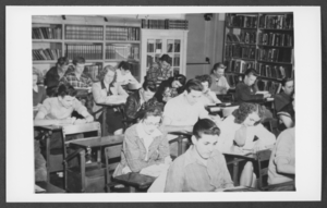
Photograph of students in a study hall/library, Boulder City, Nevada, March 21, 1932
Date
1932-03-21
Archival Collection
Description
Description provided with image: "Combination study hall-library. This is Room 2 shown on the Bureau of Reclamation School Building Plan, No. 45- D1538. March 21, 1932. L-R: Row 1 Ted Lettler, (?), Jones; Row 2: Gene McDonald, Glenn Miller, We Pymm (?), Bob Nellis; Row 4: (?), Glen Nazer, Don Watts, Jim Welsh."
Image
Wilbur and Toni Clark at a formal dinner at the Hotel Astor in New York City, New York, 1958
Level of Description
File
Archival Collection
Toni and Wilbur Clark Photographs
To request this item in person:
Collection Number: PH-00302
Collection Name: Toni and Wilbur Clark Photographs
Box/Folder: Folder 10
Collection Name: Toni and Wilbur Clark Photographs
Box/Folder: Folder 10
Archival Component
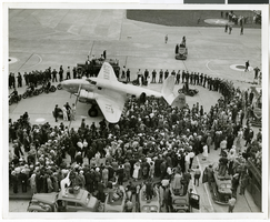
Photograph of crowds at Floyd Bennett Airfield, New York, July 14, 1938
Date
1938-07-14
Archival Collection
Description
The black and white view of Howard Hughes' Lockheed 14 aircraft after performing its final landing on the Round the World flight at Floyd Bennett Airport, New York. Description printed on photograph's accompanying sheet of paper: "Police circle Lockheed-14 at Floyd Bennett Airport."
Image

Map of California, Utah, Nevada, Colorado, New Mexico and Arizona, circa 1867
Date
1865 to 1869
Description
39 x 56 cm. Relief shown by hachures. "Entered according to act of Congress in the year 1864, by A.J. Johnson in the Clerks Office of the United States for the Southern District of New York." Atlas page numbers in upper margin: 67-68. Primer meridians: Greenwich and Washington, D.C. On verso: History and statistical view of the West India islands or Columbian Archipelago and Historical and statistical view of Mexico and Central America. Shows proposed railroads, locations of Indian tribes, natural features, counties, mines, mail routes, trails and routes of exploring expeditions. Has decorative border. Southern part of Nevada was added to the state in 1867 and is part of Nevada on this map, but Lincoln County was established in 1867 and is not on this map. This map was still probably published in 1867 in spite of someone's having written "1864" in pencil in the lower right corner of the Library's copy. Original publisher: A.J. Johnson.
Image