Search Results
Kerin Scianna Rodgers Papers
Identifier
Abstract
The Kerin Scianna Rodgers Papers (1974-1986) consist of article clippings, memorandums, Democratic voting advertisements, election plans, 1986 list of primary candidates, and personal notes. Also included are district court cases, correspondence, and election day instructions.
Archival Collection
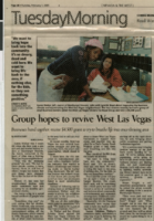
Newspaper clipping, Group hopes to revive West Las Vegas, Las Vegas Review-Journal, February 1, 2005
Date
Archival Collection
Description
Las Vegas Review-Journal article featuring Karen Walker, co-owner of Hamburger Heaven with her mother Helen Anderson.
Text
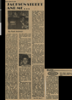
Newspaper clipping, Jackson Street and Me.., Las Vegas Sentinal-Voice, August 23, 1984
Date
Archival Collection
Description
Sentinel-Voice feature article describes Karen Walker (aka Knee-C) and her family ownership of Hamburger Heaven.
Text
Sigma Theta Tau events: photographic slides, 1989 November-1990 January
Level of Description
Archival Collection
Collection Name: History of Nursing in Southern Nevada Oral History Project Records
Box/Folder: Box 01 (Restrictions apply)
Archival Component
Nurse and probation officer Helen Holly: ceremonial program and news clipping, 2009 March-April
Level of Description
Archival Collection
Collection Name: History of Nursing in Southern Nevada Oral History Project Records
Box/Folder: Box 01 (Restrictions apply)
Archival Component
Mary Ann Michel interview notes, retirement party notice, obituary, 2005-2006, 2013
Level of Description
Archival Collection
Collection Name: History of Nursing in Southern Nevada Oral History Project Records
Box/Folder: Box 01 (Restrictions apply)
Archival Component
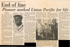
Newspaper article, Pioneer worked Union Pacific for life, Las Vegas Review-Journal, September 23, 1973
Date
Archival Collection
Description
Newspaper article about Orien Stevens who worked on railroad for 48 years, from 1925 to 1973. The article discusses his retirement, positions he was able to hold, and work environment.
Text
Audio clip from interview with Michael S. Mack, May 20, 2015
Date
Archival Collection
Description
In this audio clip Michael S. Mack discusses his family history and how the Mack family came to Las Vegas, Nevada.
Sound