Search Results
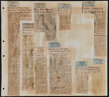

Mancuso, Gus
Gus Mancuso (Ronald Bernard Mancuso), a talented impresario, was born in Spangler, Pennsylvania in 1933. Gus grew up in Hastings, Pennsylvania as the youngest of nine children. His father, an immigrant from Italy, Joseph Mancuso, owned multiple businesses and his mother, Josephine Ceranni toiled as a stay at home mother. Despite his father’s businesses, the family struggled financially. By the eighth grade Gus moved to Rochester, New York, where his mother joined him, after his parents separated.
Person
Rocha, Fernando, 1994-
Coming from Durango and Tijuana, Mexico, Fernando Rocha’s parents met in Los Angeles in the mid-90s. Working in the sheet metal industry, his father’s career would take them to Las Vegas during the boom of the early 2000s to the slot machine industry where they would establish their family in Sunrise Manor. Little did he know that his son would later become a corporate banker working alongside the same industry with Wells Fargo.
Person

Topographic map of Boulder Canyon Project, Boulder Dam area, 1940
Date
1940
Description
Scale [ca. 1:221,760. 1 in. to approx. 3.5 miles] ; 1 map : col. ; 51 x 71 cm ; Relief shown by contours and spot heights ; Includes township and range grid ; "Map no. 40-40" ; Includes index map ; Shows power lines, triangulation stations, boundary monuments, roads, telephone lines, mines, bench marks, etc. ; U.S. Dept. of the Interior, Bureau of Reclamation
Image
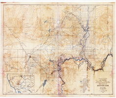
Topographic map of Boulder Canyon Project, Hoover Dam area, 1932
Date
1932
Description
Scale [ca. 1:221,760. 1 in. to approx. 3.5 miles] ; 1 map : col. ; 51 x 62 cm ; Relief shown by contours and spot heights ; "Prepared in Washington Office from compilation made in Las Vegas Office." ; "Map no. 24000." ; Includes township and range grid ; Shows power lines, triangulation stations, boundary monuments, roads, telephone lines, mines, bench marks, etc. ; Department of the Interior, Bureau of Reclamation.
Image
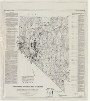
Earthquake epicenter map of Nevada, December 1964
Date
1964-12
Description
Scale 1:1,000,000 (W 120°--W 114°/N 42°--N 35°). Title in upper right margin: Earthquake epicenter map ; "Nevada earthquake epicenters for the period from about 1852 to 1961 are plotted on the accompanying map." ; "Contour interval 1,000 feet." ; "Supported by grant no. AF-AFOSR-62-285 of the Air Force of Scientific Research." ; "December 1964." ; "Base from NBM Map 17." ; "One million scale set." ; Includes bibliographical references ; Includes text and index. Nevada Bureau of Mines, University of Nevada
Text