Search the Special Collections and Archives Portal
Search Results
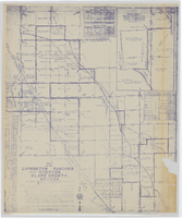
Map of the Livingston Ranches near Overton, Clark County, Nevada, March 27, 1920
Date
1920-03-27
Description
Cadastral map. "Las Vegas Plat Book 1, page 42 --Lower left hand corner. "Survey completed March 27th, 1920, J. T. McWilliams, O. E." "Inset plat showing fractional areas adjacent to section corner sections = 12-13 Tp16S.R.67E, 7-18 Tp16S.R68E." Signed by the surveyor on March 28, 1920, and notarized. Includes an inset plat showing fractional area adjacent to section corner, sections 12-13 Tp. 16 S. R. 76 E., 7-18 Tp. 16 S. R. 6 8 E. Includes table of areas of tracts and table of reference ties to scribe marked objects. Recorded in Book 1, page 42 in the County Recorder of Deed's office. Includes township and range grid. Original publisher: Clark County, State of Nevada : D.H. Livingston, 1920, Scale: 600, blue, 82 x 68 cm.
Image
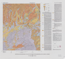
Surficial geologic map of the Specter Range NW quadrangle, Nye County, Nevada, 1989
Date
1989
Description
58 x 47 cm., on sheet 74 x 81 cm., folded in envelope 30 x 24 cm. Relief shown by contours and spot heights. "Geology mapped in 1984-85." Includes text, bibliography, and location maps. "Prepared in cooperation with the U. S. Deparment of Energy." "Base from U. S. Geological Survey, 1961. Photorevised 1983. 10,0000-foot grid ticks based on Nevada coordinate system, central zone. 1000-meter Universal Transverse Mercator grid ticks, zone 11, shown in blue." Original publisher: U. S. Geological Survey, Series: Miscellaneous investigations series map I, Scale: 1:24 000.
Image
Pagination
Refine my results
Content Type
Creator or Contributor
Subject
Archival Collection
Digital Project
Resource Type
Year
Material Type
Place
Language
Records Classification

