Search Results

Film transparency of Boulder City, Nevada, circa 1931-1936
Date
1931 to 1936
Archival Collection
Description
An image showing an aerial view of Boulder City. The outlines of the small city are distinctively marked by the stark contrast between the city's greenery and the surrounding desert. Note: Bits of the airplane from which the image itself was taken can be seen in the upper right corner of the photograph.
Image
Las Vegas City Commission Minutes, December 8, 1959 to February 17, 1960
Date
1959-12-08 to 1960-02-17
Archival Collection
Description
Bound volume of Las Vegas City Commission Minutes, December 8, 1959 to February 17, 1960
Text
Las Vegas City Commission Minutes, November 20, 1957 to December 2, 1959
Date
1957-11-20 to 1959-12-02
Archival Collection
Description
Bound volume of Las Vegas City Commission Minutes, November 20, 1957 to December 2, 1959
Text
Las Vegas City Commission Minutes, November 7, 1949 to May 21, 1952
Date
1949-11-07 to 1952-05-21
Archival Collection
Description
Bound volume of Las Vegas City Commission Minutes, November 7, 1949 to May 21, 1952
Text
Las Vegas City Commission Minutes, February 17, 1937 to August 4, 1942
Date
1937-02-17 to 1942-08-04
Archival Collection
Description
Bound volume of Las Vegas City Commission Minutes, February 17, 1937 to August 4, 1942
Text
Las Vegas City Commission Minutes, January 7, 1947 to October 26, 1949
Date
1947-01-07 to 1949-10-26
Archival Collection
Description
Bound volume of Las Vegas City Commission Minutes, January 7, 1947 to October 26, 1949
Text
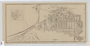
Cadastral map of Boulder City, Nevada, 1940
Date
1905-04-23
Description
A. M. S. Jan. 1940 in the lower left-hand corner. 1 map ; 61 x 30 cm. Cadastral map. "No. 40-1" in the lower right-hand corner. Shows block and lot numbers, buildings, water supply and sewage system, leased areas.
Image
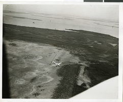
Photograph of the landing of Howard Hughes' Lockheed 14 aircraft, New York, July 14, 1938
Date
1938-07-14
Archival Collection
Description
The black and white, aerial view of Howard Hughes' Lockheed 14 aircraft preparing for its final landing on its Round the World flight in Floyd Bennett Field, New York. Typed onto a piece of paper attached to the image: "Aerial New of landing, 7-14-38. (Daily News.)" Typed onto a second piece of paper attached to the image: "Howard Hughes plane from a welcoming plane as the Round the World flight ended at Floyd Bennett Field."
Image
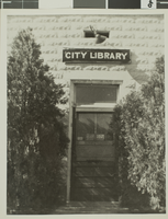
Photograph of Las Vegas City Library, 1943
Date
1943
Archival Collection
Description
The exterior of the Las Vegas City Library in Nevada.
Image
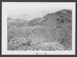
Photograph of Boulder City, Nevada, December 1964
Date
1964-12
Archival Collection
Description
Black and white photograph of mountains in Boulder City.
Image