Search Results
Howard Hughes in front of a B-23 converted bomber before taking off for New York City in Los Angeles, California, 1946 September 11
Level of Description
File
Archival Collection
Howard Hughes Public Relations Photograph Collection
To request this item in person:
Collection Number: PH-00373
Collection Name: Howard Hughes Public Relations Photograph Collection
Box/Folder: Folder 22
Collection Name: Howard Hughes Public Relations Photograph Collection
Box/Folder: Folder 22
Archival Component
B-23 converted bomber carrying Howard Hughes as it prepares to take off for New York City in Los Angeles, California, 1946 September 11
Level of Description
File
Archival Collection
Howard Hughes Public Relations Photograph Collection
To request this item in person:
Collection Number: PH-00373
Collection Name: Howard Hughes Public Relations Photograph Collection
Box/Folder: Folder 22
Collection Name: Howard Hughes Public Relations Photograph Collection
Box/Folder: Folder 22
Archival Component

Map of California, and territories of Utah, Nevada, Colorado, New Mexico and Arizona, 1864
Date
1864
Description
'Johnson's California, also Utah, Nevada, Colorado, New Mexico, and Arizona, published by A.J. Johnson, New York.' 'Entered according to act of Congress in the year 1864, by A.J. Johnson in the Clerks Office of the District Court of the United States for the southern district of New York.' Atlas page numbers in upper margin: 67-68. Relief shown by hachures. Prime meridian: Greenwich and Washington. Shows natural features, locations of Indian tribes, proposed railroad routes, routes of explorers, trails, county boundaries and populated places. Hand colored. On verso: 'Historical and statistical view of the West India Islands or Columbian Archipelago' (p. 80) and 'Historical and statistical view of Mexico and Central America' (p. 79). Scale [ca. 1:3,484,800]. 1 in. to ca. 55 miles (W 124°--W 102°/N 42°--N 32°).
Text
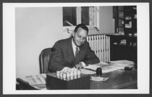
Photograph of Wayne Keeley, Boulder City, Nevada, March 31, 1932
Date
1932-03-31
Archival Collection
Description
Wayne Keeley, principal of Boulder City Elementary School, sitting at his desk in Boulder City, Nevada. Additional information provided with image: "This is the office of the principal of the Boulder City elementary school. It is the rear portion of the space originally set Aside for the girls' Cloak corridor. Reference is again made to Plan No. 45 - - D1538."
Image
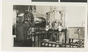
Photograph of the interior of Six Companies Hospital, Boulder City (Nev.), 1933
Date
1933
Archival Collection
Description
Interior View and hospital equipment of Six Companies Hospital in Boulder City, 1933.
Image
Boulder City, Nevada, approximately 1930-1939
Level of Description
File
Archival Collection
L. F. Manis Photograph Collection
To request this item in person:
Collection Number: PH-00100
Collection Name: L. F. Manis Photograph Collection
Box/Folder: Oversized Box SH-059
Collection Name: L. F. Manis Photograph Collection
Box/Folder: Oversized Box SH-059
Archival Component
Pioneer City Bank, 1972 May 22
Level of Description
File
Archival Collection
Frank Mitrani Photographs
To request this item in person:
Collection Number: PH-00332
Collection Name: Frank Mitrani Photographs
Box/Folder: Box 02
Collection Name: Frank Mitrani Photographs
Box/Folder: Box 02
Archival Component
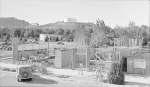
Film transparency showing building construction in Boulder City, Nevada, circa 1930s-1940s
Date
1930 to 1949
Archival Collection
Description
A shot of the construction in Boulder City, Nevada; the building is possibly the Boulder Dam Hotel; sign reads "P. S. Webb General Contractor."
Image