Search Results
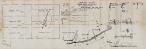
Map of the Fairday Mine, Cactus Range, Nye County (Nev.), May 25, 1916
Date
1916-05-25
Description
Scale 200 ft. to one inch.
Image
Plat map of the claim of George Wingfield (Yankee Doodle and Desert Rose Lodes), Esmeralda County (Nev.), 1910
Date
1910
Description
Plat map of the claim of George Wingfield (Yankee Doodle and Desert Rose Lodes), Esmeralda County (Nev.), 1910
Image

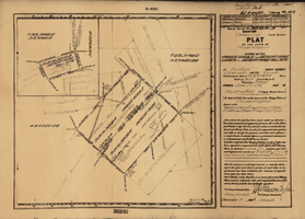
Plat of the Texas and Lone Star Lodes, Goldfield (Nev.), November 11, 1905
Date
1905-11-11
Description
Caption: U.S. Surveyor General for Nevada plat for mining claim
Image
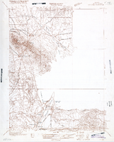
Map of Nevada, Lincoln County, Ely Range Quadrangle, Lincoln County (Nev.), 1921
Date
1921
Description
Map of Nevada, Lincoln County, Ely Range Quadrangle, Lincoln County (Nev.), 1921
Image
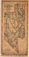
Map of Lincoln County (Nev.), 1908
Date
1908
Description
Scale [ca. 1:380,160]. 1 in. to approx. 6 miles (W 116 --W 114 /N 39 --N 35 ) ; 1 map : hand col., mounted on linen ; 115 x 54 cm ; Relief shown by hachures and spot heights ; Hand colored ; Shows range and township grid ; Shows towns, railroads, proposed railroads, wagon roads and springs ;
Image
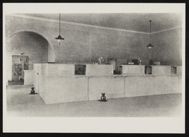
Interior view of First State Bank, Las Vegas, Nevada: photographic print
Date
1925
Archival Collection
Description
From the Elizabeth Harrington Photograph Collection (PH-00291). Inscription with image reads: "First State Bank built in 1906. Notice the cuspidors. Photo taken 1925." - E(lizabeth) Harrington.
Image