Search Results
Transcript of interview with Courtney Mooney by Suzanne Becker, July 30, 2007
Date
Archival Collection
Description
Courtney Mooney is the Urban Design Coordinator for the City of Las Vegas. Her job description includes a knowledge of historic preservation, which is her passion. In this interview she shares her professional and personal thoughts about John S. Park Neighborhood. She moved to John S. Park in 2002. As a professional she explains that "how I look at preserving neighborhoods or buildings, is more of a community preservation, not saving the individual building for the individual building's sake..." Courtney offers a big picture of the neighborhood's past, present and future. John S. Park, like so many other Las Vegas neighborhoods, was built during World War II and has been affected by history of segregation and the wave of changing demographics, and the work that went into the plan and requirements to be designated a historic neighborhood. Courtney provides a summary of the story about the land, its ownership and what lead to the foundation of the neighborhood: from John S. Park to George Franklin and John Law, to Mary Dutton and explains how the proposed development of the land differed from other communities being built to FHA standards and specifics that declared Las Vegas a Defense City in the 1940s. She lists the factors that made the neighborhood a logical and important target for the historic designation, a small neighborhood tucked away, that is "a snapshot of the types of people that were coming here," filled with community leaders, entrepreneurs, blue-collar and casino workers. She also mentions about the missed opportunity of the Las Vegas High School neighborhood for preservation while supporting the John S. Park designation.
Text
Adobe Springs Apartment Complex, 1986 December 03; 1987 May 01;
Level of Description
Scope and Contents
This set includes: index sheet, site plans, floor plans, exterior elevations, foundation plans, framing plans, roof plans, building section, construction details, interior elevations, finish/door/window schedules, electrical details, fixture schedule, electrical schematics, fire alarm plans, HVAC plans, plumbing plans, plumbing schematics and general specifications.
This set includes duplicates of the same bid set.
Archival Collection
Collection Name: Gary Guy Wilson Architectural Drawings
Box/Folder: Roll 013
Archival Component
Renaissance Center III: Cellular One Building: Originals, 1992 August 12; 1992 August 14
Level of Description
Scope and Contents
This set includes: index sheet, exterior elevations, finish/door/window schedules, general specifications, floor plans, roof plans, reflected ceiling plans, interior elevations, foundation plans, framing plans, building sections, lighting plans, fixture schedules, HVAC plans, plumbing plans, electrical plans, electrical schedules, construction details and site plans.
This set includes drawings for Vista Group, Inc (client).
Archival Collection
Collection Name: Gary Guy Wilson Architectural Drawings
Box/Folder: Roll 365
Archival Component
Smoke Ranch: Phase I, 1988 October 06; 1989 April 06
Level of Description
Scope and Contents
This set includes drawings for the Mueller Group (client) by Condrad H. Rickwartz (engineer), James H. Glover (engineer) and Bronken Engineering Chartered (engineer).
This set includes: index sheet, redlining, site plans, floor plans, exterior elevations, foundation plans, framing plans, roof plans, building sections, general specifications, construction details, interior elevations, electrical plans, fixture schedules, HVAC plans and grading plans.
Archival Collection
Collection Name: Gary Guy Wilson Architectural Drawings
Box/Folder: Roll 502
Archival Component
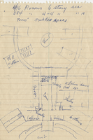
Architectural sketch of the Hacienda (Las Vegas), general layout of the property, 1951-1956
Date
Archival Collection
Description
Rough sketch of the general layout of the proposed Lady Luck, which later became the Hacienda (Las Vegas). Original medium: blue pen on notebook paper.
Site Name: Hacienda
Address: 3590 Las Vegas Boulevard South
Image
Film transparency of the gravel testing laboratory, Las Vegas, September 20, 1929
Date
Archival Collection
Description
Image
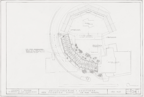
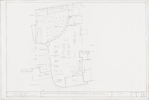
Architectural drawing of the New Frontier Hotel and Casino (Las Vegas), reconstruction and additions plot plan, October 12, 1960
Date
Archival Collection
Description
Plan for reconstruction and additions for the New Frontier in 1960.
Site Name: Frontier
Address: 3120 Las Vegas Boulevard South
Image
Architectural drawing of the New Frontier Hotel and Casino (Las Vegas), reconstruction and additions plan, December 9, 1960
Date
Archival Collection
Description
Plan for reconstruction and additions for the New Frontier in 1960.
Site Name: Frontier
Address: 3120 Las Vegas Boulevard South
Image

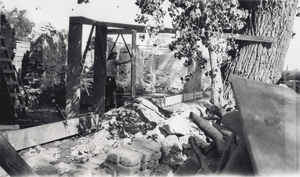
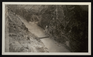
Photograph of construction of roads and bridge across Colorado River, Hoover Dam, circa 1930-1935
Date
Archival Collection
Description
Image
Photograph of construction of roads and bridge across Colorado River, Hoover Dam, circa 1930-1935
Date
Archival Collection
Description
Image