Search Results
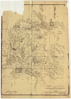
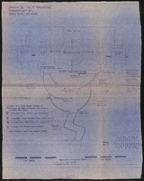
Map of approved mineral surveys in the Goldfield Mining District, Goldfield (Nev.), 1908
Date
1908
Description
Scale [ca. 1:9,600]. 1 in. to 800 feet. (W 117 14'--W 117 09'/N 37 46'--N 37 41') ; 1 map ; 129 x 97 cm ; Blueline print ; Includes township and range grid ; "Copyright 1908 by Davis and Byler. 1911." ; Library's copy has upper-left corner torn off and has circles drawn around and diagonal lines drawn on certain claims ;
Image
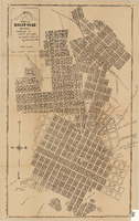
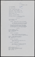
Map of Goldfield (Nev.), 1907
Date
1907
Description
Scale: [ca. 1:4,800] 1 inch = 400 ft ; 1 map ; 66 x 39 cm ; Plat map ; "April 25, 1907." ; Library's copy has notes handwritten in pencil along right margin with arrows to locations on map: "Ramsey Street ended Columbia St." "MacMaskrs office." "Lived on Euclid ave in adobe house." " Lived in Tent House Sundog Ave." ;
Image