Search Results
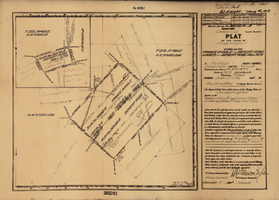
Plat map of the claim of George Wingfield (Yankee Doodle and Desert Rose Lodes), Esmeralda County (Nev.), 1910
Date
1910
Description
Plat map of the claim of George Wingfield (Yankee Doodle and Desert Rose Lodes), Esmeralda County (Nev.), 1910
Image
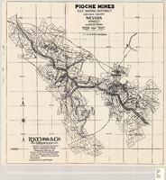
Map of the Pioche mines, Ely Mining District, Lincoln County (Nev.), 1909
Date
1909
Description
Scale unreadable ; 1 map ; 42 x 40 cm ; Photocopy. [United States ; s.n., 198-?] ; Includes township and range grid ; Includes wagon roads ;
Image
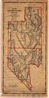
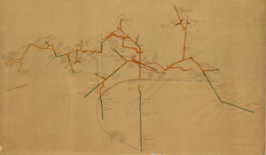
Map of Lincoln County (Nev.), 1908
Date
1908
Description
Scale [ca. 1:380,160]. 1 in. to approx. 6 miles (W 116 --W 114 /N 39 --N 35 ) ; 1 map : hand col., mounted on linen ; 115 x 54 cm ; Relief shown by hachures and spot heights ; Hand colored ; Shows range and township grid ; Shows towns, railroads, proposed railroads, wagon roads and springs ;
Image
Map of the Tonopah Mining District, Nye County (Nev.), 1905
Date
1905
Description
Scale [ca.1:12,804. 1 in. to approx. 1,067 ft.] ; 1 map ; on sheet 92 x 106 cm ; Relief shown by hachures ; Title supplied by cataloger ; Probably a preliminary black and white edition of the colored map copyrighted by Bradford and Bradford in 1905
Image
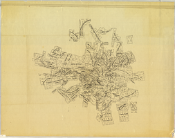
Map of the Mohawk Mine, 3rd level, Esmeralda County (Nev.), 1900-1925
Date
1900 to 1925
Description
Sectional mining map; hand-drawn and annotated in colored pencil
Image