Search Results
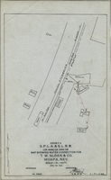
Map showing water connection for T. W. Sloan & Co., Moapa, Nevada, December 28, 1914
Date
Archival Collection
Description
Image
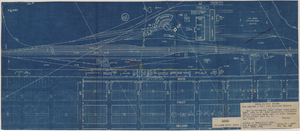
Map to accompany joint letter dated April 20th, 1931 to Mr. Gray concerning construction of proposed water main to serve lessees in Industrial Unit No. 1, Las Vegas, Nevada, April 20, 1931
Date
Archival Collection
Description
Image
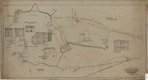
Map showing proposed improvement of Las Vegas Springs, Las Vegas, Nevada, September 21, 1916
Date
Description
'Exhibit A'. 'Approved Sept. 21, 1916.' 'W.E.J.'"--Lower left corner. 'L-44-50 to 61. T-75 - 17 & 46'--Upper left corner. Includes discharge figures and plans for improvements to springs Scale [ca. 1:240]. 1 in. to 20 feet. -- Scale [ca. 1:2,400]. 1 in. to 200 ft. Vertical scale [ca. 1:48]. 1 in. to 4 feet. -- Scale [ca. 1:4,800]. 1 in. to 100 feet. Library's copy has "Proposed layout" written on it in pencil near lower center and other markings in red. Contents: Detail at springs -- Profile -- Alignment.
Image

Map of the Livingston Ranches near Overton, Clark County, Nevada, March 27, 1920
Date
Description
Image

Surficial geologic map of the Specter Range NW quadrangle, Nye County, Nevada, 1989
Date
Description
Image

Geologic map of the Jangle Ridge quadrangle, Nye and Lincoln Counties, Nevada, 1965
Date
Description
Image
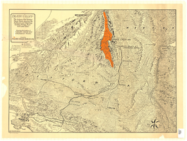
Map of Death Valley and surrounding areas in southern California, southern Nevada and Arizona, 1930
Date
Archival Collection
Description
Image

Plat of H.F.M & M addition to city of Las Vegas, Clark County, Nevada, comprising the west 1/2 of N.W. 1/4 Sec. 27, Twp. 20 S., R. 61 E., M.D.B & M, March 8, 1924
Date
Description
Image
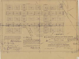
Map of Clark's Las Vegas Townsite, May 8, 1905
Date
Archival Collection
Description
Text
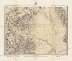
Map of part of south western Colorado, January 10, 1878
Date
Description
38 x 49 cm. Relief shown by hachures and spot heights. "Atlas sheet no. 61(D)." "Issued Jan. 10th 1878." "Expeditions of 1873, 74, 75 & 76 under the command of 1st. Lieut. Geo. M. Wheeler, Corps of Engineers, U.S. Army." Prime meridians: Washington, D.C. and Greenwich. Includes sectional diagram showing how atlas sheets fit together. "Weyss, Lang & Herman, del." "By order of the honorable the Secretary of War." "Under the direction of Brig. General A. A. Hunphreys, Chief of Engineers, U. S. Army." " J. C. Spiller, Louis Nell, topographical assistants." "Expeditions of 1873, 74, 75 & 76 under the command of 1st. Lieutenant William L. Marshall, Corps of Engineers, U. S. Army, 1st Lieutenant Eric Bergland, Corps of Engineers, U. S. Army, Executive Officers and field astronomers." Original publisher: U.S. Geographical Surveys West of the 100th Meridian, Scale 1 inch to 4 miles or 1:253440.
Image