Search Results
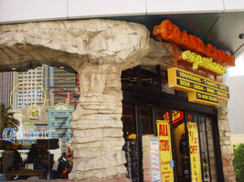
Photographs of Grand Canyon Experience signs, Las Vegas (Nev.), 2002
Date
Archival Collection
Description
Site address: 3791 S Las Vegas Blvd
Sign owner: M H & K Enterprises
Sign details: The Grand Canyon Experience is directly North of the MGM next to the GameWorks complex. Above the clear glass entrances to the outdoor scenic tour's facility is a large building front designed marquee design, as well as a smaller version over the entrance facing northwest.
Sign condition: Structure 5 Surface 3 Lighting 5
Sign form: Fascia
Sign-specific description: The marquee reads Grand Canyon in yellow channel letters outlined in yellow neon, the insides are orange with orange neon in the middle. Experience is spelled in a cursive style orange channel letters with orange neon and incandescent bulbs on the interior. The two texts are supported on a steel framework of interconnecting steel pipes. The shape looks as if it is a bow pointed toward the ground. Two steel poles run vertically approximately 16 feet from the edge of the support system. They run toward the ground against the wall and stop to square i18" tall 10 inch deep, yellow, message box with a black surface. The neon whit von inside of the red channel letters reads "Shop Grand Avenue" in an all caps Arial style text. Two halogen lamps project off of the top of the sign and illuminate a three-dimensional sculpted caricature of a hiker. The entire structure is supported on the West wall of the building. The logo itself spans seventy-eight and a half feet at it's widest and is approximately twenty-three feet tall. Below the NW entrance to the establishment, a smaller version of the giant marquee sign sits above the door. Aluminum channel letters spell " Grand Canyon," with orange argon on the interiors. Below that sits a three-tiered back lit message panel. It forms a shape reminiscent of an upside down step pyramid. The top section actually contains yellow argon in nine-inch cursive text spelling experience. The three stepped cabinet is of a polished aluminum. The text sits on sheet metal raceways.
Sign - type of display: Neon; Incandescent; Backlit
Sign - media: Steel; Fiberglass; Plastic
Sign - non-neon treatments: Paint
Sign animation: Chasing, flashing, oscillating
Notes: The text, which resides on the southern wall and reads "Casino," is filled with incandescent bulbs that all illuminate at the same time, and oscillate. They then shut off at the same time, and then repeat. The raceways of incandescent bulbs chase each other while the neon, which surrounds the back lit, plastic, screens on this wall flash on then off. The bottom two raceways sandwiching the reflective panel chase from left to right, while the remainder of the raceways surrounding the signs, run right to left. The incandescent bulbs on the pylon chase each other gracefully up the length of the pylon. The animation is patterned so as to appear as if a section of several bulbs are pulsing its way up the towers, hugging the edge of the bulbous tops. The raceways continue around the east face of the building. The umbrellas in the plaza behind the pylon, also are animated with incandescent bulbs chasing each other downward along the raceways.
Sign environment: The Grand Canyon Experience is a rather large sign but is dwarfed by the immense MGM pylon just to the south of it. It is accented by faux rock serving as door jambs for the actual entrances.
Sign manufacturer: Mikohn Lighting and Sign
Sign - date of installation: 2000- 08
Sign - thematic influences: The actual theme of the sign is correspondent to that of the business, which the sign advertises. The text does not appear to be associated with any particular theme, but hold a style complimentary to each other. An element of theming is still evident with the faux rock facade, and the sculpted figure on top of the sign.
Sign - artistic significance: If not significant for simply combining different elements to create a completely self-contained sign, it fits into the movement in Las Vegas's history, which is geared more toward the family. The cartoon-like representation of a hiker, the fake rocks, the bright colors, and location in a strip mall, which centered on such establishments as Gameworks and M&M World, all point to the conclusion that families are welcome.
Surveyor: Joshua Cannaday
Survey - date completed: 2002
Sign keywords: Fascia; Neon; Incandescent; Backlit; Steel; Fiberglass; Plastic; Paint
Mixed Content
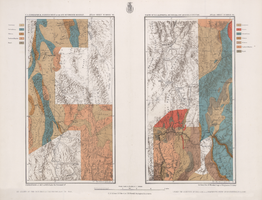
Maps of geographical surveys of parts of California, southeastern Nevada, Arizona and southwestern Utah, made under the command of George M. Wheeler, 1872-1873
Date
Description
Image
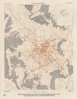
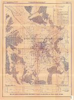
Index map showing locations of geologic sections on plate 2 and wells on plates 2 and 3, Las Vegas Valley, Nevada, 1981 (Water-supply paper 2320-A)
Date
Description
Image
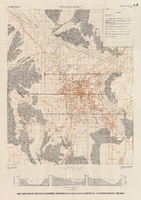
Map and basin profiles showing thickness of valley-fill deposits, Las Vegas Valley, Nevada, 1981
Date
Description
Image
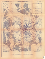
Index map showing locations of geologic sections on plate 2 and wells on plates 2 and 3, Las Vegas Valley, Nevada, 1981 (Open-file report 84-130)
Date
Description
Image
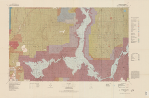
Map and basin profiles showing thickness of valley-fill deposits, Las Vegas Valley, Nevada, 1981 (color variation)
Date
Description
Image
Topographic map of Lake Mead quadrangle, Nevada and Arizona, 1979
Date
Description
Image
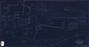
Map showing location of proposed water line to be installed along Los Angeles & Salt Lake Railroad Co. Track No. 8, Las Vegas, Nevada, May 1, 1931
Date
Archival Collection
Description
Label in lower right coner: 'Union Pacific System. Los Angeles & Salt Lake Railroad Co. Form 30, No. 6-4002. Las Vegas, Nevada. Location of proposed water line to be installed along Track No. 8. Scale 1" = 100'. Chief Engineer's Office, L.A. & S.L.R.R. Co., Los Angeles, Caif. May 1, 1931. Dwg. No. 36103.' Handwritten in red pencil on label: 'W.O. 9798.' Accompanies: Work Order Authority for Extensions and Additions to Exisiting Property, Los Angeles & Salt Lake Railroad Co., May 1, 1931. (Box 25 Folder 80-12).
Image
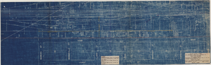
Blueprint showing proposed improvement of Las Vegas Springs, Las Vegas, Nevada, September 21, 1916
Date
Archival Collection
Description
'Exhibit A'. 'Approved Sept. 21, 1916.' '2-N-1719' handwritten in lower right corner. 'W.E.J."--Lower left corner. "L-44 - 50 to 61. T-75 - 17 & 46"--Upper left corner. Includes discharge figures and plans for improvements to springs. Scale [ca. 1:240]. 1 in. to 20 feet. -- Scale [ca. 1:2,400]. 1 in. to 200 ft. Vertical scale [ca. 1:48]. 1 in. to 4 feet. -- Scale [ca. 1:4,800]. 1 in. to 100 feet. 1 map. Contents: Detail at springs -- Profile -- Alignment.
Image