Search Results

Geologic map of Las Vegas Valley, Nevada, 1982
Date
1982
Description
At top of map:'Department of the Interior, U.S. Geological Survey. Prepared in cooperation with the Clark County Department of Comprehensive Planning. Water supply paper 2320-A, plate 1.' At bottom of map: ' Base from U.S. Geological Survey, 1:100,000, Boulder City, Ariz.-Nev., Las Vegas, Nev.-Calif., Mesquite Lake, Nev.-Calif., 1978; Lake Mead, Nev.-Ariz., 1979. Geology from Malmberg (1965); Longwell and others (1965); Haynes (1967); Bingler (1977); Bell and Smith (1980); Bell (1981); Matti and Bachhuber (1982); and Matti and Morton (1982a, b); modified by R. W. Plume, 1981.' Shows township and range lines. Scale 1:100,000 (W 115°30´--W 115°00´/N 36°30´--N 36°00´). Series: U.S. Geological Survey water-supply paper2320-A. Originally published as plate 1 of Ground-water conditions in Las Vegas Valley, Clark County, Nevada. Part I. Hydrogeologic framework / by Russell W. Plume, published by the U.S. Geological Survey in 1989 as Water-supply paper 2320-A.
Image
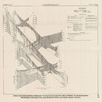
Fence diagram showing lithology of valley-fill deposits and summary of water-bearing properties for valley-fill and bedrock units, Las Vegas Valley, Nevada, 1981 (Water-supply paper 2320-A)
Date
1981
Description
'Department of the Interior, U.S. Geological Survey. Water-supply paper 2320-A, plate 2.' 'Prepared in cooperation with the Clark County Department of Comprehensive Planning.' 'Geology by R.W. Plume, 1981.' Scale [ca. 1:95,040. 1 in.=approx. 1.5 miles]. Series: U.S. Geological Survey water-supply paper2320-A. Originally published as plate 2 of Ground-water conditions in Las Vegas Valley, Clark County, Nevada. Part I. Hydrogeologic framework / by Russell W. Plume, published by the U.S. Geological Survey in 1989 as Water-supply paper 2320-A. "Prepared in cooperation with the Clark County Department of Comprehensive Planning."
Text

Map showing general geology and areas of artesian flow of the Las Vegas, Pahrump, and Indian Spring Valleys, Clark and Nye Counties, Nevada, 1946
Date
1947
Description
'United States Department of Interior, Geological Survey, Water Resources Bulletin No. 6.' 'State Engineer of Nevada.' Relief shown by contours. Includes township and range lines. Scale [ca. 1:126,720. 1 in.=approx. 2 miles]. Series: Water resources bulletin (Carson City, Nev.)no. 6. Originally published as plate 1 in Ground water in Las Vegas, Pahrump, and Indian Spring Valleys, Nevada : a summary / G. B. Maxey and T. W. Robinson, prepared in cooperation with the United States Department of the Interior, Geological Survey, and published as no. 6 of the Water resources bulletin.
Image

Map showing configuration of potentiometric surfaces in Paleozoic and Cenozoic aquifers in the area between the Las Vegas Valley and the Amargosa Desert, Nevada, 1963
Date
1963
Description
'Department of the Interior, United States Geological Survey. TEI-840.' 'Prepared in cooperation with the U.S. Atomic Energy Commission.' 'Contours in northwest Las Vegas Valley from Malmberg, 1961.' Relief shown by contours. Shows township and range lines. Scale [ca. 1:253,440. 1 in.=aprrox. 4 miles] (W 114°00´--W 115°00´--N 37°00´/N 36°00´). Originally published in A summary of the ground-water hydrology of the area between the Las Vegas Valley and the Amargosa Desert, Nevada : with special reference to the effects of possible new withdrawals of ground water / by Isaac J. Winograd, published by the U.S. Geological Survey in 1963 as number 840 of the Trace elements investigations report.
Image

Surficial geologic map of Las Vegas Valley, Nevada, circa 1981
Date
1977 to 1985
Description
'United States Department of the Interior, Geological Survey. Open-file report, 84-130, plate 1.' 'Prepared in cooperation with the Clark County Department of Comprehensive Planning.' 'Base from U.S. Geological Survey 1:100,000, Boulder City, Ariz.-Nev., Las Vegas, Nev.-Calif., Mesquite Lake, Nev.-Calif., 1978, Lake Mead, Nev.-Ariz., 1979.'Geology from Malmberg (1965); Longwell and others (1965); Haynes (1967); Bingler (1977); Bell and Smith (1980); Bell (1981); Matti and Bachhuber (1982); and Matti and Morton (1982a and b); modified by R. W. Plume, 1981.' Shows township and range lines. Scale [ca. 1:102,960. 1 in.=approx. 1.625 miles] (W 115°30´--W 115°00´/N 36°30´--N 36°00´). Series: Open-file report (Geological Survey (U.S.))84-130. Originally published as plate 1 of Ground-water conditions in Las Vegas Valley, Clark County, Nevada. Part I. Hydrogeologic framework / by Russell W. Plume, published by the U.S. Geological Survey in 1984 as Open-file report 84-130.
Image
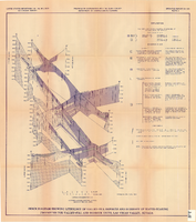
Fence diagram showing lithology of valley-fill deposits and summary of water-bearing properties for valley-fill and bedrock units, Las Vegas Valley, Nevada, 1981 (Open-file report 84-130)
Date
1981
Description
'United States Department of the Interior, Geological Survey. Open-file report 84-130, plate 2.' 'Prepared in cooperation with the Clark County Department of Comprehensive Planning.' 'Geology by R.W. Plume, 1981.' Scale [ca. 1:31,680. 1 in.=approx. .5 miles]. . Series: Open-file report (Geological Survey (U.S.))84-130. Originally published as plate 2 of Ground-water conditions in Las Vegas .Valley, Clark County, Nevada. Part I. Hydrogeologic framework / by Russell W. Plume, published by the U.S. Geological Survey in 1984 as Open-file report 84-130. "Prepared in cooperation with the Clark County Department of Comprehensive Planning."
Text

Map of Las Vegas, Nevada, annotated to show different soil types, September 2, 1948
Date
1948-09-02
Archival Collection
Description
'Types of soil as determined by James M. Montgomery for use in appraisal. (Copy). LRM 7/10/52'--handwritten in blue pencil in lower right corner of map. 'September 2, 1947. Revised September 2, 1948.' Soil was designated as badly corrosive, mildly corrosive, or non-corrosive by hand-drawn colored lines and hand-printed labels. Soil was surveyed to measure its effect on water pipes. Scale [ca. 1:7,200] 1 in.=600 feet.
Image

Blueprint map showing proposed water pipeline from Big Spring to Las Vegas, Nevada, January 24, 1911
Date
1911-01-24
Archival Collection
Description
'S.P.L.A.&S.L.R.R. Los Angeles Division. Map of pipe line from Big Spring. Las Vegas, Nev. Approved: Jan. 24, 1911. E.M. Jessup, E.M. of W.' In lower right corner: '4-U-323.' Scale [ca. 1:2,400] 1 in.=200 feet. Relief shown by contours. North is to upper right.
Image
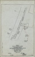
Map showing water connection for T. W. Sloan & Co., Moapa, Nevada, December 28, 1914
Date
1914-12-28
Archival Collection
Description
'Exhibit A.' 'S.P.L.A.&.S.L.R.R., Los Angeles Division.' 'Dec. 28, 1914.' 'Approved, [signed] E.M. Jessup, E.M. of W.' '2-T-168A' hand-printed in lower right corner. Scale: 1 in. = 100 ft.
Image
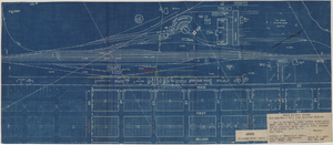
Map to accompany joint letter dated April 20th, 1931 to Mr. Gray concerning construction of proposed water main to serve lessees in Industrial Unit No. 1, Las Vegas, Nevada, April 20, 1931
Date
1931-04-20
Archival Collection
Description
'Union Pacific System. Los Angeles & Salt Lake Railraod Company.' 'Office of Industrial Engr., Los Angeles, California, April 20th, 1931. Dwg. No. 588.' Scale: 1" = 200'.
Image