Search Results
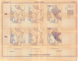
Maps showing distribution of coarse- and fine-grained deposits in the upper 1,000 feet of valley fill, Las Vegas Valley, Nevada, 1981 (Open-file report 84-130, plate 3)
Date
1981
Description
'United States Department of the Interior, Geological Survey. Open-file report 84-130, plate 3.' 'Prepared in cooperation with the Clark County Department of Comprehensive Planning.' 'Base from U.S. Geological Survey, 1:250,000, Las Vegas and Kingman, 1969.' 'Geology from Malmberg (1965); Longwell and others (1965); and J. R. Harrill, 1979. Lithology by R.W. Plume, 1981.' Contents: Coarse-grained deposits: 0-200 feet below land surface; 200-700 feet below land surface; 700-1,000 feet below land surface -- Fine-grained deposits: 0-200 feet below land surface; 200-700 feet below land surface; 700-1,000 feet below land surface. Scale [ca. 1:310,464. 1 in.=approx. 4.9 miles]. Series: Open-file report (Geological Survey (U.S.))84-130 Originally published as plate 3 of Ground-water conditions in Las Vegas Valley, Clark County, Nevada. Part I. Hydrogeologic framework / by Russell W. Plume, published by the U.S. Geological Survey in 1984 as Open-file report 84-130.
Image
Map of explorations and surveys south of the Central Pacific Railroad made by the U.S. Army Corps of Topographical Engineers, 1871
Date
1871
Description
'Preliminary topographical map embracing in skeleton a portion only of the notes from surveys made in accordance with Par.II Special Orders No. 109 War Dept., March 18th, 1871 and letter of instructions of Brig. General A.A. Humphreys, Chief of Eng'rs. dated March 23rd, 1871. Conducted under the immediate direction of 1st Lieutenant Geo. M. Wheeler, Corps of Eng'rs., assisted by 1st Lieutenant D.W. Lockwood, Corps of Eng'rs. and 2nd Lieutentant D.A. Lyle, 2nd U.S. Artillery, during the summer and fall of 1871. Louis Nell, chief topographer and draughtsman.'' At head of map: 'Explorations in Nevada and Arizona. U.S. Engineer Department.' In lower left corner: 'Note: This map is a hasty and partial compilation from the topographical data already received, many still remaining en route. Upon it is projected in skeleton the groundwork of the area examined. All points except the prominent astronomical positiions are subject to lsight modification upon the final map.' Shows area through central Nevada, eastern California, and central Arizona. Relief shown by hachures. Published by the War Dept. Scale [ca. 1:1,520,640]. 1 in. to 24 miles (W 118°--W 109°/N 41°--N 32°).
Image

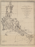
Map showing detailed topography of the country traversed by the reconnaissance expedition through southern & southeastern Nevada, 1869
Date
1869
Description
At top of map: 'Reconnaissance Maps, Department of California.' In lower right corner: 'Photolith. by the N.Y. Lithg. Engrg. & Prtg. Co.' 'In charge of, Lieut. Geo. M. Wheeler, U.S. Engineers; assisted by Lieut. D.W. Lockwood, Corps of Engineers,U.S.A., 1969.' 'P.W. Hamel, chief topographer and draugthsman.' 'Officially compiled and published at the Engineer Office, Head Quarters Department of California in 1869 and 70 by order of Brigadier General E.O.C. Ord. Comm'dg. [signed] Geo. M. Wheeler, Lieutenant of Engineers In Charge, Head Quarters Dept. of Cal. Oct. 26th, 1870.' Includes information from railroad maps, the United States Geological Survey of the 40th parallel and from Lieutenant Ives' explorations along the Colorado. Map includes camps, astronomical stations, good and bad wagon roads, trails, springs, settlements, mining districts, state and county boundaries and the watershed between the Humboldt and Colorado Basin. Shows most of eastern half of Nevada. Relief shown by hachures and spot heights. Scale: [1:760,320]. 1 in. to approx. 12 miles. (W 117°00´--W 113°00´/N 41°45´--N 35°45´). Series: Reconnaissance maps. Military map / Department of Californiano. 1.miles. Library's copy has counties hand-outlined in colored markers.
Image
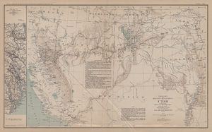
Map of territory and military department of Utah, 1860
Date
1860
Description
Compiled in the Bureau of Topographical Engineers of the War Department. Chiefly for Military purposes under the authority of Honorable J.B. Floyd, Secretary of War, 1860. 42 x 69 cm. Shows towns, wagon roads, explorers' routes, railroads, forts, etc., approx. from Albuquerque, N.M. to Fort Lane, Or. and from Fort Laramie, Wyo. to Los Angeles, Calif. "Corrections and additions in reference to railroads in California, etc., were made in January, 1862 ..." "The new military posts at Fort Bidwell, ... located from a map loaned ... January 16, 1866." "Atlas to accompany the official records of the Union and Confederate armies, 1861-1865. Plate CXX."--Upper margin. Atlas published by the Washington Government Printing Office in 1891-95. Relief shown by hachures. "Julius Bien & Co. Lith. N.Y." Includes text and list of authorities. Inset: March routes of Army of the Tennessee from Savannah, Ga., to Columbia, S.C., 1865, accompanying the report of Maj. Gen O.O. Howard, U.S. Army, series I, vol. XLVII, part I. Includes bibliographical references. Washington Territory is shown prior to becoming Washington state. The geographic region of Southwest is referred to as the New Southwest. Original publisher: Govt. Print. Off..
Image

Map showing detailed topography of the country traversed by the reconnaissance expedition through southern & southeastern Nevada, 1869 (reproduction)
Date
1869
Description
At top of map: 'Reconnaissance Maps, Department of California.' 'In charge of, Lieut. Geo. M. Wheeler, U.S. Engineers; assisted by Lieut. D.W. Lockwood, Corps of Engineers,U.S.A., 1969.' 'P.W. Hamel, chief topographer and draugthsman.' 'Traced 11-13-67.' 'BGS'; the G is enclosed in an arrowhead shape. 'Officially compiled and published at the Engineer Office, Head Quarters Department of California in 1869 and 70 by order of Brigadier General E.O.C. Ord. Comm'dg. [signed] Geo. M. Wheeler, Lieutenant of Engineers In Charge, Head Quarters Dept. of Cal. Oct. 26th, 1870.' Includes information from railroad maps, the United States Geological Survey of the 40th parallel and from Lieutenant Ives' explorations along the Colorado. Map includes camps, astronomical stations, good and bad wagon roads, trails, springs, settlements, mining districts, state and county boundaries and the watershed between the Humboldt and Colorado Basin. Shows most of eastern half of Nevada. Relief shown by hachures and spot heights. Scale indeterminable. (W 117°00´--W 113°00´/N 41°45´--N 35°45´). Series: Reconnaissance maps. Military map / Department of Californiano. 1. Reproduction. Map is printed in purple. Scale of original map: [1:760,320]. 1 in. to approx. 12 miles. Includes dots hand-colored with red pencil marking Indian rancherias.
Image

neo000062-001
Description
Sign animation: Chasing, flashing, oscillating
Notes: The logo cabinets which adorn the entrances on the elevated walkways: The letters start with both rows of text in the off position. The top row flashes on, while the bottom row is dark then the bottom row illuminates, as the top row goes dark. Once the top row flashes off it flashes back on so that both rows of text are briefly illuminated simultaneously before they both go dark and the sequence stars over again. While this is going on the incandescent bulbs which line all of the raceways are chasing each other from left to right on the horizontal planes, while the arched sections chase each other downward. The triangular peaks which radiate around the top of the logo sign, flash on and off in a sequence which chase each other downward. First the top center peak flashes on, then the next sequential triangular channel on both sides illuminate simultaneously, flash off, then the next two in the series illuminate. The resultant effect is a chasing pattern starting from the top. The sister animation is located on almost the exact same design on the porte cochere. I would think the previous smaller sign would be based on the larger porte cochere. The other variance besides obvious size difference is the that the channel letters are filled with incandescent bulbs instead of neon. The animation is a bit simpler as well. The incandescent bulbs oscillate continuously while the triangular pan channels which create the radiating crown, animate. The neon in the channels chase each other as described in the smaller walk way version, while the text continues until the entire text flashes off, then on, off, then begin to animate once again. All of the bulbs, which line the raceways of the exterior edge of the porte cochere, as well as the encrustation of bulbs on the brass bull nose portion, animate in rapid succession. All the raceway bulbs chase each other while the bulbs on the brass portion continually oscillate. Animation continues on the east face of the building with the entrances first. The principle for these two signs is oscillation and chasing. All bulbs on the underside of the entrance, as well as in the logo, oscillate rapidly. All bulbs on the raceways chase each other. Further on the surface of the building as well, the Pepsi cola wall sign is found displaying a very unique form of animation, seen here on the strip. The signage for the Pepsi ad is located on the eastern wall. (Detailed in specific description) The Incandescent bulbs which fill the inside of the text that spells Pepsi, chase each other from left to right, leaving all the bulbs in its path illuminated, as if writing out the word Pepsi. The neon bars located within the tilted bottle of Pepsi are illuminated, and chase each other downward, leaving the bars it its path dark. As this sequence in taking place, the waving tubes of neon illuminate, flashed subtly making the neon appear as soda pouring out of the bottle. As the tubing flows then the vertical neon bars in the cup illuminate one at a time making the cup appear as if it is filling up. The text above each of the painted fires head, flashes back and forth as if talking to each other as well. ESPN ZONE animation: The letters in the vertical blade portion of the ESPN Zone illuminate one at a time, starting from the top. Once the entire phrase is lit, in flashes off then on then off, before restating. The orange and red neon tubing which resides inside the pan channels that represent flames flash on and off in a relaxed manner as if to animate the flickering of the flames. The small incandescent bulbs on the black portions above the main matrix reader board flash on and off subtly.
Notes: The logo cabinets which adorn the entrances on the elevated walkways: The letters start with both rows of text in the off position. The top row flashes on, while the bottom row is dark then the bottom row illuminates, as the top row goes dark. Once the top row flashes off it flashes back on so that both rows of text are briefly illuminated simultaneously before they both go dark and the sequence stars over again. While this is going on the incandescent bulbs which line all of the raceways are chasing each other from left to right on the horizontal planes, while the arched sections chase each other downward. The triangular peaks which radiate around the top of the logo sign, flash on and off in a sequence which chase each other downward. First the top center peak flashes on, then the next sequential triangular channel on both sides illuminate simultaneously, flash off, then the next two in the series illuminate. The resultant effect is a chasing pattern starting from the top. The sister animation is located on almost the exact same design on the porte cochere. I would think the previous smaller sign would be based on the larger porte cochere. The other variance besides obvious size difference is the that the channel letters are filled with incandescent bulbs instead of neon. The animation is a bit simpler as well. The incandescent bulbs oscillate continuously while the triangular pan channels which create the radiating crown, animate. The neon in the channels chase each other as described in the smaller walk way version, while the text continues until the entire text flashes off, then on, off, then begin to animate once again. All of the bulbs, which line the raceways of the exterior edge of the porte cochere, as well as the encrustation of bulbs on the brass bull nose portion, animate in rapid succession. All the raceway bulbs chase each other while the bulbs on the brass portion continually oscillate. Animation continues on the east face of the building with the entrances first. The principle for these two signs is oscillation and chasing. All bulbs on the underside of the entrance, as well as in the logo, oscillate rapidly. All bulbs on the raceways chase each other. Further on the surface of the building as well, the Pepsi cola wall sign is found displaying a very unique form of animation, seen here on the strip. The signage for the Pepsi ad is located on the eastern wall. (Detailed in specific description) The Incandescent bulbs which fill the inside of the text that spells Pepsi, chase each other from left to right, leaving all the bulbs in its path illuminated, as if writing out the word Pepsi. The neon bars located within the tilted bottle of Pepsi are illuminated, and chase each other downward, leaving the bars it its path dark. As this sequence in taking place, the waving tubes of neon illuminate, flashed subtly making the neon appear as soda pouring out of the bottle. As the tubing flows then the vertical neon bars in the cup illuminate one at a time making the cup appear as if it is filling up. The text above each of the painted fires head, flashes back and forth as if talking to each other as well. ESPN ZONE animation: The letters in the vertical blade portion of the ESPN Zone illuminate one at a time, starting from the top. Once the entire phrase is lit, in flashes off then on then off, before restating. The orange and red neon tubing which resides inside the pan channels that represent flames flash on and off in a relaxed manner as if to animate the flickering of the flames. The small incandescent bulbs on the black portions above the main matrix reader board flash on and off subtly.