Search Results

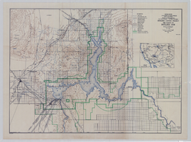
Topographic map of Boulder Canyon Project, Boulder Dam area, 1940
Date
1940
Description
Scale [ca. 1:221,760. 1 in. to approx. 3.5 miles] ; 1 map : col. ; 51 x 71 cm ; Relief shown by contours and spot heights ; Includes township and range grid ; "Map no. 40-40" ; Includes index map ; Shows power lines, triangulation stations, boundary monuments, roads, telephone lines, mines, bench marks, etc. ; U.S. Dept. of the Interior, Bureau of Reclamation
Image
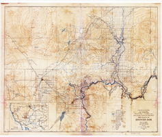
Topographic map of Boulder Canyon Project, Hoover Dam area, 1932
Date
1932
Description
Scale [ca. 1:221,760. 1 in. to approx. 3.5 miles] ; 1 map : col. ; 51 x 62 cm ; Relief shown by contours and spot heights ; "Prepared in Washington Office from compilation made in Las Vegas Office." ; "Map no. 24000." ; Includes township and range grid ; Shows power lines, triangulation stations, boundary monuments, roads, telephone lines, mines, bench marks, etc. ; Department of the Interior, Bureau of Reclamation.
Image
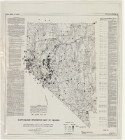
Earthquake epicenter map of Nevada, December 1964
Date
1964-12
Description
Scale 1:1,000,000 (W 120°--W 114°/N 42°--N 35°). Title in upper right margin: Earthquake epicenter map ; "Nevada earthquake epicenters for the period from about 1852 to 1961 are plotted on the accompanying map." ; "Contour interval 1,000 feet." ; "Supported by grant no. AF-AFOSR-62-285 of the Air Force of Scientific Research." ; "December 1964." ; "Base from NBM Map 17." ; "One million scale set." ; Includes bibliographical references ; Includes text and index. Nevada Bureau of Mines, University of Nevada
Text
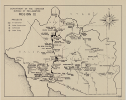
Map of Bureau of Reclamation Region III, August 1, 1945
Date
1945-08-01
Description
31 x 40 cm. "8-1-45. Ness." and "116951" in lower right corner. Shows reclamation projects in operation, under construction, authorized and under study in Arizona, and parts of New Mexico, Utah, Nevada, and California. "Department of the Interior, Bureau of Reclamation" in upper left corner. Original Publisher: Dept. of the Interior, Bureau of Reclamation.
Image
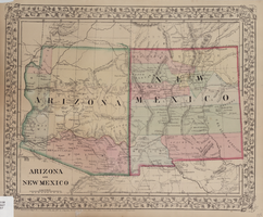
Map of Arizona and New Mexico, 1867
Date
1867
Description
26 x 32 cm. Relief shown by hachures. "Entered according to act of Congress in the year 1867 by S. Augustus Mitchell in the Clerks Office of the District Court for the Eastern District of Pennsylvania." Includes decorative border of grape vines. Shows Tucson as capital of Arizona; shows various trails including Cook's Wagon Route, Marcy's Route, and Kearney's Route. Written in pencil in lower right corner: 135. Original publisher: S.A. Mitchell.
Image
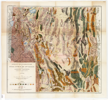
Geologic map of the Atomic Energy Commission Nevada Proving Grounds Area, Nye and Clark Counties, Nevada, 1952
Date
1952
Description
'At top of map: ' United States Department of the Interior. Geological Survey.' ' Bulletin 1021, Plate 32.' At bottom of map: 'Geology by Donald E. Hibbard and Mike S. Johnson, 1952.' 'Base from USAF Aeronautical Chart and Information Service, April 1952.' 'Interior--Geological Survey, Washington, D.C. MR-3767.' Scale 1:63,360 (W 116°10--W 115°55/N 37°15--N 36°40)
Geological Survey bulletin, 1021
Image
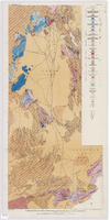
Geological reconnaissance map of Nevada south of the 40th parallel and adjacent California, 1903
Date
1903
Description
'Compiled from all available information by J.E. Spurr. Topographic base chiefly adapted from the maps of the Wheeler Survey.' 'U.S. Geological Survey, Bulletin No. 208, Pl. 1.' 'A. Hoen & Co. Lith. Baltimore, MD.' Relief shown by hachures and spot heights. Scale [ca. 1:950,000. 1 inch to approximately 15 miles] (W 120°--W 114°/N 40°--N 36°). Geological Survey bulletin, 208.
Image

Map of California and Territories of New Mexico and Utah, 1862
Date
1862
Description
Scale [ca. 1:3,231,360. 1 in. to approx. 51 miles] (W 125°00--W 103°30/N 42°00--N 31°45) ; 1 map : hand col. ; 40 x 60 cm., on sheet 46 x 68 cm ; Relief indicated by hachures and spot heights ; Prime meridians: Greenwich and Washington, D.C ; Decorative border ; Hand colored ; Atlas p. numbers in upper margin: 58-59 ; Date est. from territorial borders and county configuration ; Shows natural features, locations of Indian tribes, proposed railroad routes, routes of explorers, trails, county boundaries and populated places ; Johnson and Ward
Image

Map of California and territories of New Mexico and Utah, circa 1861
Date
1859 to 1862
Description
'Compiled, drawn, and engraved under the supervision of J.H. Colton and A.J. Johnson.' Relief shown by hachures and spot heights. Scale [ca. 1:3,041,280]. 1 in. to approx. 48 miles (W 124°--W 103°/N 42°--N 31°). Hand coloredPrime meridians: Greenwich and WashingtonPlates 54 & 55 removed from Johnson's New illustrated family atlas of the world, with descriptions geographical, statistical and historical ... New York, 1862Title page of atlas.
Image