Search Results
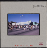
Photographic slide of Native Americans in a parade in Carson City, Nevada, October 31, 1963
Date
1963-10-31
Archival Collection
Description
A view of a Nevada Day centennial parade procession featuring Native Americans marching.
Image

1981 Intertribal Native American ceremony, Gallup, New Mexico: panoramic photographs
Date
1981-08-08
Archival Collection
Description
From the Bob Paluzzi Panoramic Photographs
Image
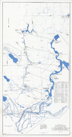
Map and operational diagram, lower Colorado River, Lees Ferry to Gulf of California, June 1973
Date
1973-06
Description
84 x 43 cm. "Map no. 423-300-59." Insets: [Salton Sea]--Operational diagram, no scale. Includes index to gaging stations. Shows dams, canals, levees, pumping plants, etc. "Map compiled from Coast and Geodetic Survey sectional aeronautical charts, and Bureau of Reclamation data." Original publisher: U.S. Dept. of the Interior, Bureau of Reclamation.
Image
Photograph of Captain Pete, early 1900s
Date
1900 to 1920
Archival Collection
Description
Transcribed from photo: "Washo - 1. Captain Pete was one of the early spokesmen for the Washo in their dealings with whites. He was often called upon to defend Lake Tahoe and the pine nut hills. Inter-Tribal Council of Nevada. Courtesy of Nevada Historical Society."
Image
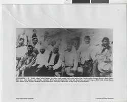
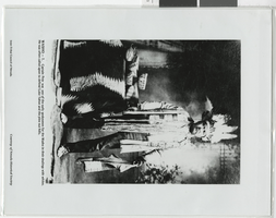
Photograph of Indian leaders, Ruby Valley (Nev.), circa 1920
Date
1919 to 1921
Archival Collection
Description
Transcribed from the picture, "Shoshone - 4. Ruby Valley Indian leaders in a photo taken around 1920 at the cabin of Joe Temoke on the Overland Ranch in Ruby Valley. First row: John Carson, Joe Temoke, Lazy Jim, Billy Long, (standing) Andy, Frank Jim. Second row: Johnny Long, Joe Billy Smith, George Moore, John Nookie, Jack Temoke, Machach Temoke, Bert Moon. Third row: White Man, Friday Long, Seamond Temoke. Inter-Tribal Council of Nevada. Courtesy of Edna Patterson."
Image
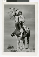
Photograph of Lone Wolf on horseback, 1920s-1940s
Date
1920 to 1949
Archival Collection
Description
Lone Wolf, a Blackfoot Indian from Browning, Montana and son of James Willard Schultz, poses in traditional Native American dress on horseback.
Image
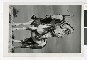
Photograph of Lone Wolf on horseback, 1920s-1940s
Date
1920 to 1949
Archival Collection
Description
Lone Wolf, a Blackfoot Indian from Browning, Montana and son of James Willard Schultz, poses in traditional Native American dress on horseback.
Image

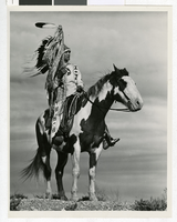
Photograph of Lone Wolf on horseback, 1920s-1940s
Date
1920 to 1949
Archival Collection
Description
Lone Wolf, a Blackfoot Indian from Browning, Montana and son of James Willard Schultz, poses in traditional Native American dress on horseback.
Image
Photograph of Lone Wolf on horseback, 1920s-1940s
Date
1920 to 1949
Archival Collection
Description
Lone Wolf, a Blackfoot Indian from Browning, Montana and son of James Willard Schultz, poses in traditional Native American dress on horseback.
Image