Search Results

Aerial photograph of Las Vegas, looking east down Fremont Street, circa late 1940s
Date
Archival Collection
Description
Aerial view of Las Vegas, looking east down Fremont Street. Jackie Gaughan's Plaza was originally named Union Plaza and is currently called the Plaza Hotel and Casino.
Transcribed Notes: Transcribed from back of photo: "Fremont Street in downtown Las Vegas as it appeared in the late 1940s. In the foreground stands the Union Pacific Depot where Jackie Gaughan's Plaza stands today."
Image

Photograph of Tamarisk trees sticking out of the water in St. Thomas, Nevada, circa June, 1938
Date
Archival Collection
Description
The tops of tamerisk trees show above the water line of Lake Mead at St. Thomas, Nevada.
Transcribed Notes: Transcribed from photo sleeve: "What was once the main throughfare and entrance to the prosperous little Mormon town of St. Thomas now shows only the tops of the tamarix (sic) trees which lined its irrigation ditches. (phto by E. Edwards)"
Image
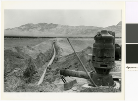
Photograph of irrigation pump and water line, Amargosa Valley, Nevada, 1980
Date
Archival Collection
Description
View of a water line and pump in the Amargosa Valley looking southwest toward the Funeral Mountains.
Transcribed Notes: Transcribed from photo sleeve: "Amargosa Valley looking southwest toward the Funeral Mountains, 1980, showing a 10" water line and pump to supply a circle sprinkler system. The pump is a 75 horsepower electric turbine pump that supplies two sprinkler systems with a total of 1,450 gallons per minute. At that capacity, the pump only draws water down 3 inches in the well."
Image
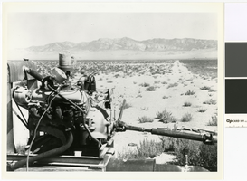
Photograph of a butane powered pump engine on the T & T Ranch, Nevada, circa 1958
Date
Archival Collection
Description
Since the Amargosa Valley did not have electricity until 1964, all pumps were run by combustion engines, like this one on the T & T Ranch.
Transcribed Notes: Transcribed from photo sleeve: "Land on the T & T Ranch, Amargosa Valley, Nye County, Nevada, about 1958 or 1959. Commercial electricity was not available in the Amargosa Valley until 1964. Until then all water pumping was done with combustion engines running at the wells. Pictured here is a butane-operated motor, running a pump on the property belonging to Hank Records."
Image
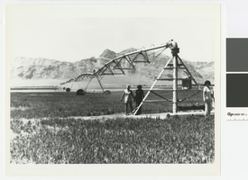
Photograph of a pivot watering system, Hank Record Ranch, Nevada, 1980
Date
Archival Collection
Description
Irrigation pivot watering alfalfa on the property of Hank Records.
Transcribed Notes: Transcribed from photo sleeve: "Amargosa Valley, Nye county, Nevada, 1980. Pivot watering system has just been installed on the property belonging to Hank Records and the alfalfa is beginning to grow. When alfalfa is first seeded, oats are also planted as a cover crop. The oats, which protect the tender alfalfa seedlings, are later cut, and the alfalfa takes over."
Image
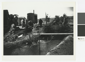
Photograph of diesel pumps, Hank Record Ranch, Nevada, 1956
Date
Archival Collection
Description
Diesel pumps on the Record Ranch.
Transcribed Notes: Transcribed from photo sleeve: "Detroit diesels powering pumps on Hank Record's property, Amargosa Valley, Nye County, Nevada, about 1956. (Diesels were installed by Mantzer Detroit Diesel out of Sparks, Nevada.) Records brought the trailer in the background from Prescott, Arizona; it was the first structure in the Amargosa Valley Farm Area aside from those on the T & T Ranch. The trees are Balm of Gileads."
Image
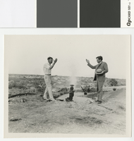
Photograph of Fred Hesse and Fred Balzar opening an artesian well in Las Vegas, circa 1930
Date
Archival Collection
Description
Las Vegas mayor J. Fred Hesse (left) and Nevada governor Fred Balzar (right) at opening of an artesian well in Las Vegas
Transcribed Notes: Notes on photo sleeve: "Las Vegas Mayor J. Fred Hesse (left) and Nev. Governor Fred Balzar at opening of an artesian well in Las Vegas, ca. 1929-32"; Stamped on back of photo: G. L. Ullom. 104 Fremont Street. Las Vegas, Nevada
Image
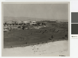
Photograph of North Las Vegas golf course, northwest direction, circa 1965
Date
Archival Collection
Description
North Las Vegas golf course with Parks and Recreation Building and city water tanks.
Transcribed Notes: Notes from photo sleeve: "North Las Vegas Golf Course (Par 3) with Parks and Recreation Building and city water storage tanks"; Notes on back: "NLV Par 3 Golf Course with P & R Bldg. and city water storage tanks."
Image
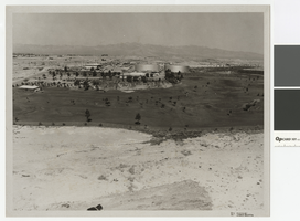
Photograph of North Las Vegas golf course, westward direction, circa 1965
Date
Archival Collection
Description
North Las Vegas golf course with Parks and Recreation Building and city water tanks.
Transcribed Notes: Notes from photo sleeve: "North Las Vegas Golf Course (Par 3) with Parks and Recreation Building and city water storage tanks"; Notes on back: "NLV Par 3 Golf Course with P & R Bldg. and city water storage tanks."
Image
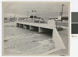
Photograph of water running high in flood channel and North Las Vegas Boulevard flood channel
Date
Archival Collection
Description
Flood channel with water running high under North Las Vegas Boulevard. Signs on front for 91 and 93 freeways
Transcribed Notes: Notes from photo sleeve: "Las Vegas Boulevard North and North Las Vegas flood channel, ca. 1970s." Notes on back: "Las Vegas Blvd North and NLV flood channel."
Image