Search Results
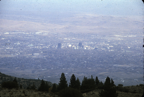
Slide of Reno, Nevada, circa 1970s
Date
1970 to 1979
Archival Collection
Description
A panoramic view of Reno, Nevada, taken from the top of a nearby mountain.
Image
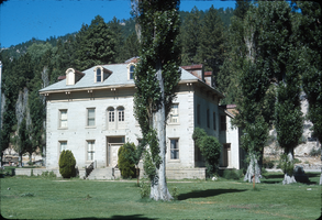
Slide of the Bowers Mansion, Washoe Valley, Nevada, circa 1970s
Date
1970 to 1979
Archival Collection
Description
The Bowers Mansion was built in 1863 by Lemuel "Sandy" Bowers and his wife, Eilley Orrum Bowers, and is a prime example of the homes built in Nevada by the new millionaires of the Comstock Lode mining boom. The mansion, designed by J. Neely Johnson, a builder and ex-governor of California, combined Georgian Revival and Italianate architectural styles. It was modeled after a design conceived by Eilley based on her recollection of elegant buildings in her native Scotland. Following the death of Sandy Bowers in 1868, Eilley fell on hard financial times. She generated income by renting out rooms in the mansion and hosting parties and picnics on the grounds. The mansion hosted a ball for the women's suffrage movement and was the location of the annual Miner's Ball. The period of 1873–75 was the height of the mansion's popularity. However, this was not enough to overcome Eilley's debts and she finally lost her home to foreclosure in 1876. The mansion was abandoned by the time Henry Riter acquired it and operated it as a resort until 1946. The building is currently owned and operated by the Washoe County Parks Department. Some 500 Nevada families have donated period furniture housed in the mansion. The park blends the historical site with recreational facilities such as a spring-fed swimming pool, picnic areas, and a playground. The Bowers Mansion is located in Washoe Valley, within the Bowers Mansion Regional Park at 4005 Old U.S. Highway 395 North, North Washoe Valley, Nevada.
Image
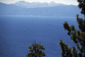
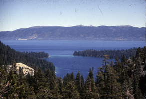
Slide of Lake Tahoe, Nevada, circa 1970s
Date
1970 to 1979
Archival Collection
Description
A view of Lake Tahoe. Snow is visible on the mountain on the far side of the lake.
Image
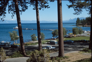
Slide of a pier at Lake Tahoe, circa 1960s-1970s
Date
1960 to 1979
Archival Collection
Description
A boat is moored at the end of a pier in Lake Tahoe. The location is unknown, but is possibly South Lake Tahoe, California.
Image
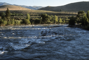
Slide of the Truckee River, circa 1970s
Date
1970 to 1979
Archival Collection
Description
The location that the photograph was taken is unknown, but is most likely in Nevada. The Truckee River is a stream in the U. S. states of California and Nevada. The river flows northeasterly and is 121 miles (195 km) long. The Truckee is the sole outlet of Lake Tahoe and drains part of the high Sierra Nevada, emptying into Pyramid Lake in the Great Basin. Its waters are an important source of irrigation along its valley and adjacent valleys.
Image
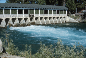
Slide of the Truckee River Dam, Tahoe City, California, circa 1970s
Date
1970 to 1979
Archival Collection
Description
Truckee River Dam at the Lake Tahoe shoreline, on the northwest side of the lake near Tahoe City, California. There is a sign posted on the dam stating "No fishing for 1000 feet below dam."
Image
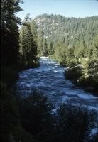
Slide of the Truckee River Canyon, circa 1970s
Date
1970 to 1979
Archival Collection
Description
A view of the Truckee River Canyon. The location that the photograph was taken is unknown.
Image
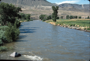
Slide of the Truckee River canyon near Reno, Nevada, circa 1970s
Date
1970 to 1979
Archival Collection
Description
A view of the Truckee River canyon near Reno, Nevada.
Image
Slide of Lake Tahhoe, May, 1966
Date
1966-05
Archival Collection
Description
A view of Lake Tahoe and Emerald Bay, May 1966. Emerald Bay is located on the California side of Lake Tahoe.
Image
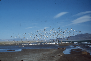
Slide of pelicans at Pyramid Lake, Nevada, circa 1970s
Date
1970 to 1979
Archival Collection
Description
A flock of pelicans at Pyramid Lake, Nevada. Some birds are wading near a sand bar, while others are airborne. Pyramid Lake is the geographic sink of the Truckee River Basin, 40 mi (64 km) northeast of Reno. Pyramid Lake is fed by the Truckee River, which is mostly the outflow from Lake Tahoe. The Truckee River enters Pyramid Lake at its southern end. Pyramid Lake has no outlet, with water leaving only by evaporation, or sub-surface seepage (an endorheic lake). The lake has about 10% of the area of the Great Salt Lake, but it has about 25% more volume. The salinity is approximately 1/6 that of sea water. Although clear Lake Tahoe forms the headwaters that drain to Pyramid Lake, the Truckee River delivers more turbid waters to Pyramid Lake after traversing the steep Sierra terrain and collecting moderately high silt-loaded surface runoff. Pyramid Lake is the site of some of the Earth's most spectacular tufa deposits. Tufa is a rock composed of calcium carbonate (CaCO3) that forms at the mouth of a spring, from lake water, or from a mixture of spring and lake water. The explorer John C. Fremont (1845) wrote about the tufas during his 1843-44 expedition and named the lake after the pyramidal-shaped island that lies along the east shore of the lake. The Paiute name for the island is Wono, meaning cone-shaped basket. The Paiute name for the lake is Cui-Ui Panunadu, meaning fish in standing water.
Image