Search Results

Photograph of flood channel west of Interstate 15 looking toward North Las Vegas, June 5, 1973
Date
Archival Collection
Description
Flood channel west of Interstate 15 looking toward North Las Vegas and Frenchman Mountain.
Transcribed Notes: Notes on back: "Flood Channel west of I-15 looking towards NLV and Sunrise Mountain." Stamped on back: "CNLV Engineering Dept."
Image

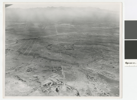
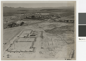
Aerial photograph of Las Vegas Wash looking northwest, June 5, 1973
Date
Archival Collection
Description
Aerial view of Las Vegas Wash at Lake Mead Blvd. and Pecos Street in North Las Vegas.
Transcribed Notes: Stamped & written on back: CNLV Engineering Dept. - Date Jun 5 1973; Project - Land use Vegas Wash - SE; Lake Mead & Pecos Flood Control in county
Image
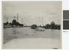
Photograph of flooding on Carey Avenue in North Las Vegas, 1970s
Date
Archival Collection
Description
Flooding on Carey Avenue, North Las Vegas.
Transcribed Notes: Notes on back: "Carey Ave Flooding"
Image
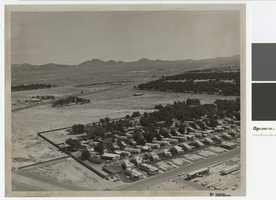
Aerial photograph of North Las Vegas looking west towards Mount Charleston, 1968
Date
Archival Collection
Description
Aerial view of North Las Vegas looking west with North Las Vegas Airport in the distance. The plane is directly over what is now I-15 and Cheyenne. In the foreground is a water tank where there are now many tanks.
Transcribed Notes: Handwritten on back: "Street Dept - Brooks, Cheyenne Area - 1968, looking west"
Image
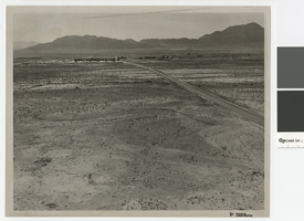
Photograph of Cheyenne Avenue looking east at Sunrise Mountain, June 5, 1973
Date
Archival Collection
Description
Cheyenne Avenue looking east at Sunrise Mountain.
Transcribed Notes: Handwritten on back: "Cheyenne looking east at sunrise. NLV - Streets & Roads - Photos" Stamped on back: "CNLV Engineering Dept."
Image
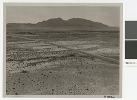
Aerial photograph over Cheyenne Avenue looking southeast, June 5, 1973
Date
Archival Collection
Description
Aerial view over Cheyenne Avenue looking southeast towards Frenchman Mountain
Transcribed Notes: Handwritten on back: "Over Cheyenne looking SE" Stamped on back: "CNLV Engineering Dept"
Image
Aerial photograph of Las Vegas Boulevard and Nellis Boulevard, June 5, 1973
Date
Archival Collection
Description
Aerial view of Las Vegas Blvd. and Nellis Blvd looking north.
Transcribed Notes: Handwritten on back: "LV Blvd & Nellis Blvd looking north" Stamped on back: CNLV Engineering Dept"
Image
Aerial photograph of Las Vegas Blvd. and Cheyenne Ave., Las Vegas, June 5, 1973
Date
Archival Collection
Description
Aerial view of Las Vegas Blvd. and Cheyenne Avenue looking north.
Transcribed Notes: Transcribed from back of photo: "Building site of Safeway"
Image

Irma I. Varela interview, March 5, 2019: transcript
Date
Archival Collection
Description
Interviewed by Barbara Tabach. Born and raised in Zacatecas, Mexico, Irma moved to Las Vegas in 1989. She is the Cultural Program Supervisor at Winchester Community Center and has devoted much of her career to preserving Hispanic cultural traditions in Las Vegas. She has been an active leader in local events such as Community Roots, International Food & Folk Life Festival, World Vibrations, and Dio de Los Muertos.
Text

Googie architectural design drawing of Brasilia Village, bird's-eye perspective, circa 1961
Date
Archival Collection
Description
Conceptual drawing of the proposed Brasilia Village hotel complex.
Address: Las Vegas; Clark County; Nevada
Image