Search Results
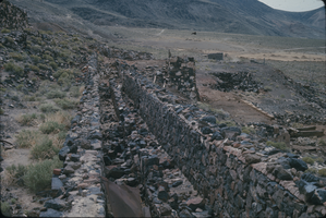
Slide of Candelaria mill ruins, Nevada, circa 1960s - 1970s
Date
1960 to 1979
Archival Collection
Description
Mill ruins in Candelaria, Nevada.
Image
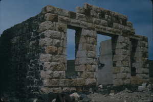
Slide of Candelaria, Nevada, circa 1960s - 1970s
Date
1960 to 1979
Archival Collection
Description
Ruins in Candelaria, Nevada.
Image

Slide of Candelaria, Nevada, circa 1960s - 1970s
Date
1960 to 1979
Archival Collection
Description
An interior view of a tunnel in Candelaria, Nevada.
Image
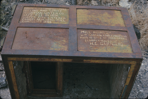
Slide of mining ruin, Candelaria, Nevada, circa 1960s - 1970s
Date
1960 to 1979
Archival Collection
Description
Ruined mining equipment at Candelaria, Nevada.
Image
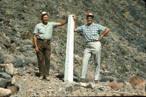
Slide of John Lytle at Emigrant (Fremont) Gap on the Old Spanish Trail, California, circa 1960s
Date
1960 to 1969
Archival Collection
Description
John Lytle (left) and Sherman "Scoop" Garside (right) at Emigrant (Fremont) Gap on the Old Spanish Trail. Emigrant Gap is a gap in a ridge on the California Trail as it crosses the Sierra Nevada, to the west of what is now known as Donner Pass. Here the cliffs are so steep that, back in the 1840s, the pioneers on their way to California had to lower their wagons on ropes in order to continue. The first official effort to mark the Old Spanish Trail across Nevada took place in 1964 when the Governor of Nevada asked Sherwin "Scoop" Garside to design and implement a Centennial project to help commemorate the Silver State's 100th birthday. Garside proposed that an appropriate Centennial project would be to mark the trace of the Old Spanish Trail across southern Nevada. The Governor concurred and directed the Nevada State government to cooperate in the project. Garside and his associate John Lytle brought together a group of friends and supporters to help fund and fabricate the white concrete posts that were used to mark the trace of the Old Spanish Trail across the state. Members of an affiliate of the local Boy Scouts of America Council helped erect thirty-three of these markers across the Mojave Desert in southern Nevada and Eastern California. The markers are inscribed with the legend "The Old Spanish Trail, 1829-1855." There are four Old Spanish Trail Historical Markers located in Nevada. One is located on U. S. 91 in Mesquite, the second is located in Fantasy Park, 1/4 mile east of Las Vegas Boulevard, North and Washington Avenue in Las Vegas, the third is located at Town Center in Blue Diamond, and the fourth is located on State 16 at Mountain Springs Summit. In 2001, the section of the Trail that runs across Nevada from the Arizona border to California (known as the "Old Spanish Trail-Mormon Road Historic District") was placed on the National Register of Historic Places.
Image
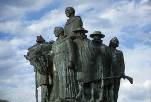
Slide of the This Is The Place Monument, Salt Lake City, Utah, circa 1990s
Date
1990 to 1999
Archival Collection
Description
A statue of early trappers that is inscribed with "This is the place." A view of the left-hand side of the This is the Place Monument. Several individual sculptures make up the full monument. The This is the Place Monument is a historical monument at the This is the Place Heritage Park, located on the east side of Salt Lake City, Utah, at the mouth of Emigration Canyon. It is named in honor of Brigham Young's famous statement in 1847 that the Latter-day Saint pioneers should settle in the Salt Lake Valley. Sculpted between 1939 and 1947 by Mahonri M. Young, a grandson of Brigham Young, it stands as a monument to the Mormon pioneers as well as the explorers and settlers of the American West. It was dedicated by LDS Church President George Albert Smith on 24 July 1947, the hundredth anniversary of the pioneers entering the Salt Lake Valley. It replaced a much smaller monument located nearby.
Image
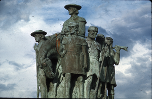
Slide of the This Is The Place Monument, Salt Lake City, Utah, circa 1990s
Date
1990 to 1999
Archival Collection
Description
A view of the right-hand side of the This is the Place Monument. Several individual sculptures make up the full monument. The This is the Place Monument is a historical monument at the This is the Place Heritage Park, located on the east side of Salt Lake City, Utah, at the mouth of Emigration Canyon. It is named in honor of Brigham Young's famous statement in 1847 that the Latter-day Saint pioneers should settle in the Salt Lake Valley. Sculpted between 1939 and 1947 by Mahonri M. Young, a grandson of Brigham Young, it stands as a monument to the Mormon pioneers as well as the explorers and settlers of the American West. It was dedicated by LDS Church President George Albert Smith on 24 July 1947, the hundredth anniversary of the pioneers entering the Salt Lake Valley. It replaced a much smaller monument located nearby.
Image
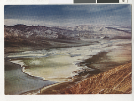
Photograph of Death Valley (Calif.), 1950-1969
Date
1950 to 1969
Archival Collection
Description
Scenic view of Death Valley. The back of the photograph/postcard reads, "167- Death Valley from Dante's View in the Black Mountains of Southern California. Bad water in the flat lands of Death Valley can be seen from Dante's view in the Black Mountains of Southern California" and "Color Card Kodachrome reproduction by Mike Roberts Studios. Berkley 4, California."
Image
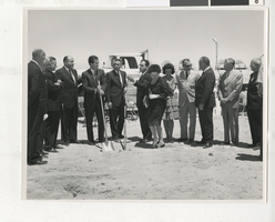
Photograph of a groundbreaking ceremony, Las Vegas (Nev.), June 5, 1963
Date
1963-06-05
Archival Collection
Description
Groundbreaking ceremony for a buildings designed most likely by Harry H. Whiteley. The two individuals holding shovels are Pat Boone (left), and Nevada Governor Grant Sawyer (right).
Image
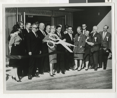
Photograph of Las Vegas Convalescent Center and manuscript description, Las Vegas (Nev.), 1950-1969
Date
1950 to 1969
Archival Collection
Description
Opening ceremony of the Las Vegas Convalescent Center, operated by the United Convalescent Hospital, with a manuscript describing the opening ceremony. Street Address: 2832 Maryland Parkway
Image