Search Results
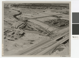
Aerial photograph of North Las Vegas flood control channel under I-15 and Civic Center Drive, June 5, 1973
Date
Archival Collection
Description
Flood control channel crossing I-15 and Civic Center Drive, Bullock's Feed and Tack store nearby.
Transcribed Notes: Notes from photo sleeve: "Aerial photo: Looking southeast. North Las Vegas flood control channel crosses I-15 and Civic Center Drive with Bulloch's Feed and Tack store next to channel. June 5, 1973." Stamped on back: "CNLV Engineering Dept." Notes on back: "Looking SE NLV Flood Control channel crosses I-15 and Civic Center Drive with Bullocks Feed and Tack store next to channel"
Image

Photograph of flood channel west of Interstate 15 looking toward North Las Vegas, June 5, 1973
Date
Archival Collection
Description
Flood channel west of Interstate 15 looking toward North Las Vegas and Frenchman Mountain.
Transcribed Notes: Notes on back: "Flood Channel west of I-15 looking towards NLV and Sunrise Mountain." Stamped on back: "CNLV Engineering Dept."
Image

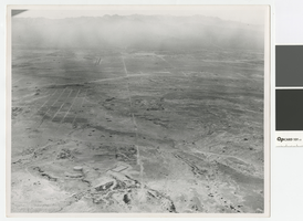
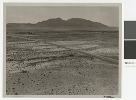
Aerial photograph of Las Vegas Wash looking northwest, June 5, 1973
Date
Archival Collection
Description
Aerial view of Las Vegas Wash at Lake Mead Blvd. and Pecos Street in North Las Vegas.
Transcribed Notes: Stamped & written on back: CNLV Engineering Dept. - Date Jun 5 1973; Project - Land use Vegas Wash - SE; Lake Mead & Pecos Flood Control in county
Image
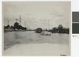
Photograph of flooding on Carey Avenue in North Las Vegas, 1970s
Date
Archival Collection
Description
Flooding on Carey Avenue, North Las Vegas.
Transcribed Notes: Notes on back: "Carey Ave Flooding"
Image
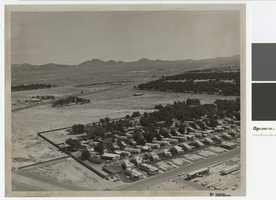
Aerial photograph of North Las Vegas looking west towards Mount Charleston, 1968
Date
Archival Collection
Description
Aerial view of North Las Vegas looking west with North Las Vegas Airport in the distance. The plane is directly over what is now I-15 and Cheyenne. In the foreground is a water tank where there are now many tanks.
Transcribed Notes: Handwritten on back: "Street Dept - Brooks, Cheyenne Area - 1968, looking west"
Image
Photograph of Cheyenne Avenue looking east at Sunrise Mountain, June 5, 1973
Date
Archival Collection
Description
Cheyenne Avenue looking east at Sunrise Mountain.
Transcribed Notes: Handwritten on back: "Cheyenne looking east at sunrise. NLV - Streets & Roads - Photos" Stamped on back: "CNLV Engineering Dept."
Image
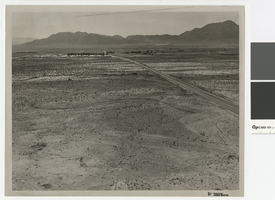
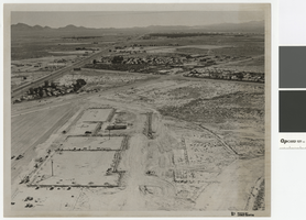
Aerial photograph over Cheyenne Avenue looking southeast, June 5, 1973
Date
Archival Collection
Description
Aerial view over Cheyenne Avenue looking southeast towards Frenchman Mountain
Transcribed Notes: Handwritten on back: "Over Cheyenne looking SE" Stamped on back: "CNLV Engineering Dept"
Image
Aerial photograph of Las Vegas Boulevard and Nellis Boulevard, June 5, 1973
Date
Archival Collection
Description
Aerial view of Las Vegas Blvd. and Nellis Blvd looking north.
Transcribed Notes: Handwritten on back: "LV Blvd & Nellis Blvd looking north" Stamped on back: CNLV Engineering Dept"
Image
Aerial photograph of Las Vegas Blvd. and Cheyenne Ave., Las Vegas, June 5, 1973
Date
Archival Collection
Description
Aerial view of Las Vegas Blvd. and Cheyenne Avenue looking north.
Transcribed Notes: Transcribed from back of photo: "Building site of Safeway"
Image
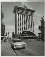
Photograph of the front exterior of the Mint (Las Vegas), 1966
Date
Archival Collection
Description
The Mint Hotel with its tower nearing completion. Stamped on original: "Las Vegas News Bureau. Las Vegas, Nevada. Convention Center. 11940. Don English. Jerry Abbott. Joe Buck. Milt Palmer. John Cook." Also visible is the California Club.
Site Name: Mint Las Vegas
Address: 128 East Fremont Street
Image