Search Results
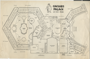
Map of Caesars Palace buildings, circa 1969
Date
1969 (year approximate)
Archival Collection
Description
Labeled map of the original buildings of Caesars Palace resort, hotel, and casino.
Image

Map of Amargosa Municipal Center: photographic print
Date
1880 (year approximate) to 1990 (year approximate)
Archival Collection
Description
Artist's rendering of Amargosa Municipal Center, Amargosa, Nevada. The architect is Alton Dean Jensen.
Image

David Weide holding up a map: photographic print
Date
1880 (year approximate) to 1990 (year approximate)
Archival Collection
Description
Mr. David Weide, a UNLV Professor in the Geoscience Department, holding up a map.
Image
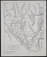
The San Pedro, Los Angeles and Salt Lake Railroad in Southern Nevada: map
Date
1906
Archival Collection
Description
From the UNLV Libraries Single Item Accession Photograph Collection (PH-00171). Plat showing country tributary to S.P.L.A. and S.L. Railroad in Southern Nevada. Compiled by J.T. McWilliams.
Image
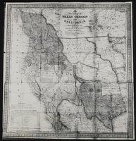
Map of Texas, Oregon, and California: map
Date
1846
Archival Collection
Description
From the UNLV Libraries Single Item Accession Photograph Collection (PH-00171). Published by S. Augustus Mitchell, Philadelphia.
Image
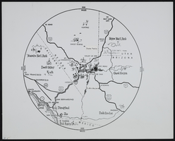
The Magic 300-Mile Circle Map: map
Date
1900 (year approximate) to 1999 (year approximate)
Archival Collection
Description
From the UNLV Libraries Single Item Accession Photograph Collection (PH-00171). The Magic 300-Mile Circle. A map showing Las Vegas as the hub of a 300-mile circle containing the most significant tourist attractions in the southwestern United States.
Image
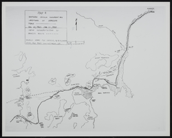
Map of Southen Nevada Geography: map
Date
1900 (year approximate) to 1999 (year approximate)
Archival Collection
Description
From the UNLV Libraries Single Item Accession Photograph Collection (PH-00171). Photo of map-Southern Nevada Geography and Landmark of Armijo's Trace.
Image
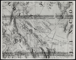
Topographic map of Nevada and California: map
Date
1950 (year approximate) to 1960 (year approximate)
Description
From the Nan Doughty Photograph Collection (PH-00240). Showing Death Valley, California, Amargosa Valley, Nevada, and the Bullfrog-Rhyolite area.
Image
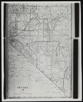
Topographic map of Nevada: map
Date
1881
Description
From the Nan Doughty Photograph Collection (PH-00240)
Image
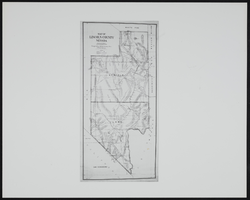
Map of Lincoln County before Clark County was created, Nevada: map
Date
1900 (year approximate) to 1999 (year approximate)
Archival Collection
Description
From the UNLV Libraries Single Item Accession Photograph Collection (PH-00171)
Image