Search Results
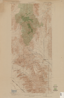
Topographic map of Goodsprings quadrangle, Nevada and California, 1919
Date
1919
Description
'R.B. Marshall, Chief Geographer; Geo. R. Davis, Geographer in charge; Topography by N.E. Ballmer and Roscoe Reeves; Control by J.E. Blackburn and L.F. Biggs. Surveyed in 1915-1916.' 'Edition of 1919.' Relief shown by hachures and spot heights. Title in lower right margin: Goodsprings. In center of top margin: Topography. Includes compilation diagram. Indicates location and density of cedar trees. Shows small portion of San Bernardino County, California. Published by U.S. Geological Survey. Scale 1:62,500 (W 115°35'00"--W 115°24'00"/N 36°02'30"--N 35°42'30"). 'Contour interval 50 feet. Datum is mean sea level.'
Text

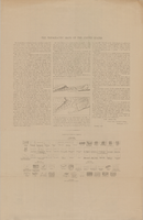
Sketch of plan and profile of present and proposed pipes and tanks and reservoirs at Sloan, Erie and Jean, Nevada, circa 1910s-1920s
Date
1910 to 1929
Archival Collection
Description
'No scale. Approved E.M. Jessup, Engr. Maintenance. 7-R-463.'
Image
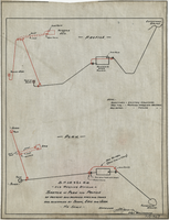
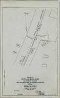
Map showing water connection for T. W. Sloan & Co., Moapa, Nevada, December 28, 1914
Date
1914-12-28
Archival Collection
Description
'Exhibit A.' 'S.P.L.A.&.S.L.R.R., Los Angeles Division.' 'Dec. 28, 1914.' 'Approved, [signed] E.M. Jessup, E.M. of W.' '2-T-168A' hand-printed in lower right corner. Scale: 1 in. = 100 ft.
Image
Map showing water connection for jail, Moapa, Nevada, December 28, 1914
Date
1914-12-28
Archival Collection
Description
'Exhibit A.' 'S.P.L.A.&.S.L.R.R., Los Angeles Division.' 'Approved, [signed] E.M. Jessup, E. M. of W.' 2-T-167A' hand-printed in lower right corner. Scale: 1 in. = 100 ft.
Image
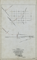
Map showing water pipeline in Arden, Nevada, May 4, 1913
Date
1913-05-04
Archival Collection
Description
'Exhibit A. S.P.L.A. & S.L.R.R. Los Angeles Division.' 'Approved May 4, 1913 [signed] E.M. Jessup, E.M. of W.' 'I-T-54.'
Image
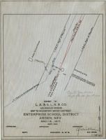
Map to accompany water contract, Enterprise School District, Arden, Nevada, September 1919
Date
1919
Archival Collection
Description
'Exhibit A. L.A. & S.L. R.R. Co., Los Angeles Division. Sept. 1919.' 'Approved [signed], C.F. Miller, Div. Engr.' 'I-W-67" hand-printed in lower right corner. 'Cancelled June 1st, 1920; Supts. file 129 - June 7th, 1920" handwritten on map. Scale: 1 in. : 100 ft.
Image
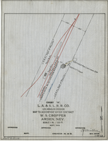
Map to accompany water contract, W. S. Cropper, Arden, Nevada, September 1919
Date
1919-09
Archival Collection
Description
'Exhibit A. L.A. & S.L. R.R. Co., Los Angeles Division. Sept. 1919. 'Approved [signed] C.F. Miller, Div. Engr.' 'I-W-68' hand-printed in lower right corner. 'Audit No 3114" hand-printed in lower left margin. Scale 1 in. = 100 ft.
Image
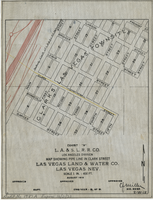
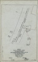
Map showing water pipeline in Clark Street, Las Vegas, Nev., August 1919
Date
1919-08
Archival Collection
Description
'Exhibit A. L.A & S.L. R.R. Co., Los Angeles Division.' ' Las Vegas Land & Water Co., Las Vegas, Nev.' 'August 1919' (?) 'Approved [signed] C.F. Miller Div. Engr. '2-W-18.' Handwritten in lower left margin: 'Audit No.1987A. Expires 12/31/23.' Pipeline marked in yellow. Area of Las Vegas in map labeled as 'Clark's Las Vegas Townsite.' Scale: 1 in. = 400 ft.
Image