Search Results
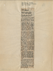
Newspaper clipping, Water wrangle solution?, Las Vegas Review-Journal, November 17, 1944
Date
Archival Collection
Description
Lorenzi recommending a pipeline from Lake Mead to supply water to Las Vegas to guarantee future development in the Las Vegas Valley.
Text
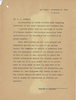
Letter from Walter R. Bracken (Las Vegas) to W. M. Jeffers, November 13, 1944
Date
Archival Collection
Description
The Chamber of Commerce agreed that the artesian water in the valley should be reserved for domestic purposes, and Lake Mead water for irrigation, but Bracken wrote that this was academic because Basic Magnesium Inc. had no excess water.
Text
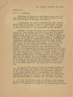
Letter from Walter R. Bracken (Las Vegas) to W. M. Jeffers, November 10, 1944
Date
Archival Collection
Description
Letter to the president of the Union Pacific appraising him of why the Las Vegas Land and Water Company was protesting the issuance of new permits to drill wells in the Las Vegas.
Text
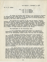
Letter from Frank Strong (Los Angeles) to G. F. Ashby, November 7, 1944
Date
Archival Collection
Description
Meeting on water in Las Vegas. Discussion included the decline in water pressure throughout the valley, watershed recharge, BMI Water, a possible water district, well drilling, and more.
Text
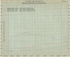
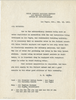
Chart of water production and consumption from the Las Vegas Land and Water Company, 1926-1944
Date
Archival Collection
Description
Chart showing the available production, average daily consumption, and the maximum daily consumption of water from 1926 to 1944
Text
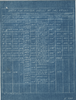
Chart showing construction data of Las Vegas Land and Water Company wells, circa 1944
Date
Archival Collection
Description
List of the Las Vegas Land and Water Company wells with details regarding each.
Text
Letter from Maxwell Kelch (Las Vegas) to W. H. Guild (Los Angeles), October 18, 1944
Date
Archival Collection
Description
Invitation from the Chamber of Commerce to attend a meeting to discuss the water situation in Las Vegas. Includes an enclosure listing the topic of a meeting held the day before to discuss the same issue.
Text
Letter from Walter R. Bracken (Las Vegas) to Frank Strong (Los Angeles), October 10, 1944
Date
Archival Collection
Description
Brief rundown of the water situation in Las Vegas, acquisition of water from Basic Magnesium Incorporated, and prevention of additional well drillings.
Text
Memo from H. H. Larson to Union Pacific Railroad Company employees about water conservation, February 13, 1942
Date
Archival Collection
Description
Notice to all railroad employees of the importance of conserving water as much as possible.
Text
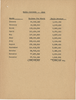
Chart of Las Vegas water consumption in 1940, circa 1941
Date
Archival Collection
Description
1940 Las Vegas water consumption by month.
Text