Search Results
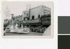
Photograph of a parade on Fremont Street (Las Vegas), 1952
Date
Archival Collection
Description
A parade float featuring characters from The Wizard of Oz passes in front of the Frontier Club on Fremont Street in Las Vegas. A sign on the side of the float says Hotel Last Frontier. Crowds of people watch from the sidewalk and street curb, and from windows and rooftops. Parts of the Golden Nugget Gambling Hall and the Santa Anita Turf & Bar are visible on the sides of the photograph.
Site Name: Fremont Street
Address: Fremont street, Las Vegas, NV
Image
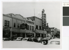
Photograph of the south side of Fremont Street (Las Vegas), summer of 1942
Date
Archival Collection
Description
A view of the south side of Fremont Street showing the Oasis Cafe, Fraternal Order of the Eagles (F.O.E.) building, and the Frontier Club. This is the present location of the Golden Nugget. Handwritten text on original: "South side of Fremont Street between First & Second. Present location of Golden Nugget. Taken in summer of 1942. Howard J Werner"'
Site Name: Fremont Street
Address: Fremont street, Las Vegas, NV
Image
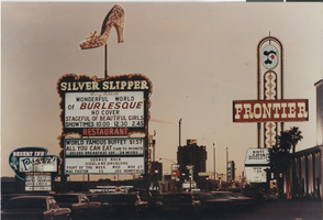
Photograph of Las Vegas hotel signs, 1968
Date
Archival Collection
Description
The signs for the Frontier, Silver Slipper and Desert Inn at twilight, with the Sands tower in the background.
Site Name: Las Vegas Strip
Address: Las Vegas Boulevard, Las Vegas, NV
Image

Photograph of a Las Vegas gambling scene, 1930s
Date
Archival Collection
Description
Gambling in an early Las Vegas casino, probably the Frontier Club. Compare the bare interior with modern casino interiors.
Site Name: Fremont Hotel and Casino
Address: 200 East Fremont Street
Image
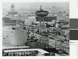
Photograph of the Las Vegas Strip, circa 1969
Date
Archival Collection
Description
Las Vegas Strip looking south showing the Riviera, the Stardust, and the Frontier Hotel. Per patron comment, the photo may have been taking around 1969.
Site Name: Las Vegas Strip
Address: Las Vegas Boulevard, Las Vegas, NV
Image
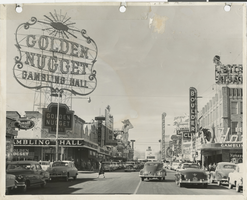
Photograph of the front exterior of the Golden Nugget and Fremont Street (Las Vegas), circa 1951
Date
Archival Collection
Description
Golden Nugget at 129 Fremont Street, circa 1951. Also visible are the Frontier Club, the Vegas Club, the Vegas Vic sign, Union Plaza, the Boulder Club, and Hotel Apache. Note: photograph is damaged.
Site Name: Fremont Street
Address: Fremont street, Las Vegas, NV
Image
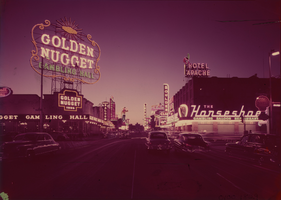
Film transparency of Fremont Street looking northwest from Second Street (Las Vegas), circa 1951
Date
Archival Collection
Description
View at dusk of Fremont Street looking northwest from the intersection at Second Street. The Golden Nugget is on the southwest corner, and the Horseshoe is on the northwest corner. Neon signs for the Boulder Club, Hotel Apache, Frontier Club, Las Vegas Club and Pioneer Club, including Vegas Vic, are seen.
Site Name: Fremont Street
Address: Fremont street, Las Vegas, NV
Image

Film transparency of Fremont Street (Las Vegas), circa 1947
Date
Archival Collection
Description
Daytime view of Fremont Street looking northwest toward the Union Pacific Railroad station. The Eldorado Club and Apache Hotel are seen at the northwest corner of Fremont and Second Streets, east of the the Boulder Club. Part of the Golden Nugget is seen on the southwest corner of Fremont and Second Streets east of the Frontier Club.
Site Name: Fremont Street
Address: Fremont street, Las Vegas, NV
Image
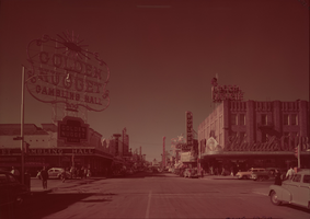
Film transparency of Fremont Street seen from Second Street, Las Vegas, Nevada, circa 1947
Date
Archival Collection
Description
Looking northwest towards the Union Pacific Railroad station from the intersection of Fremont and Second Streets, Las Vegas, Nevada. The Golden Nugget is on the southwest corner and the Eldorado Club is on the northwest corner. Signs for the Boulder Club, Pioneer Club, Las Vegas Club, Frontier Club and White Spot Cafe are also visible.
Site Name: Fremont Street
Address: Fremont Street, Las Vegas, NV
Image
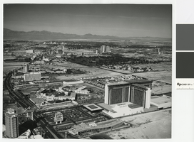
Aerial photograph of the Las Vegas Strip, circa mid 1970s
Date
Archival Collection
Description
Aerial view of the Las Vegas Strip, looking north from the former MGM Grand, since renamed Bally's. Also shown is the former Dunes Hotel, where Bellagio now stands, as well as Caesars Palace, the Flamingo, the Sands, the Frontier, Circus Circus, the Las Vegas Hilton. In the distance is Downtown Las Vegas.
Site Name: Las Vegas Strip
Address: Las Vegas Boulevard, Las Vegas, NV
Image