Search Results
Slide of the Callville ruins, Callville, Nevada, circa 1930s
Date
1930 to 1939
Archival Collection
Description
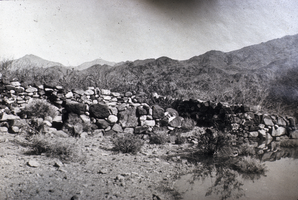
A view of the Callville ruins at Lake Mead, Nevada. Callville is a former settlement of Clark County, Nevada. Abandoned in 1869, Callville was submerged under 400 feet (120 m) of water after the Colorado River was dammed to form Lake Mead. Callville Bay recreation area is located at the site. Located 350 miles (560 km) from Salt Lake City, Calville was situated on the west bank of the Colorado River, in what was at the time Pah-Ute County, Arizona Territory. The main road to the settlement was along the Virgin River close to St. Thomas, Nevada before heading over hills to the west. A road connected Callville with the main highway at Las Vegas. Callville was established in December 2, 1864 by Anson Call, Dr. James M. Whitmore, A. M. Cannon, Jacob Hamblin and son. It was at the time the southernmost outpost of Mormon settlement. Callville was one of seven Mormon settlements on or near the Muddy River, the others being St. Thomas, Saint Joseph, Overton, West Point, Mill Point later Simonsville and Rioville on the Colorado River above its confluence with the Virgin River. Callville became the county seat of Pah-Ute County, Arizona Territory, in December 1865, before the seat was moved on October 1, 1867 to St. Thomas.
Image
Slide of Hoover Dam taken on the downstream side, circa 1970s
Date
1970 to 1979
Archival Collection
Description
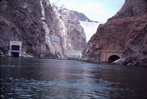
The face of Hoover Dam as seen from the river. Part of the power plant's hydroelectric generators, as well as the canyon wall outlets and stoney gate are visible on the Nevada (left) side. The spillway tunnel is visible on the Arizona (right) side. During the years of lobbying leading up to the passage of legislation authorizing the dam in 1928, Hoover Dam was originally referred to "Boulder Dam" or as "Boulder Canyon Dam", even though the proposed site had shifted to Black Canyon. The Boulder Canyon Project Act of 1928 (BCPA) never mentions a proposed name or title for the dam. When Secretary Wilbur spoke at the ceremony starting the building of the railway between Las Vegas and the dam site on September 17, 1930, he named the dam "Hoover Dam", citing a tradition of naming dams after Presidents, though none had been so honored during their terms of office. After Hoover's election defeat in 1932 and the accession of the Roosevelt administration, Secretary Ickes ordered on May 13, 1933 that the dam be referred to as "Boulder Dam". In the following years, the name "Boulder Dam" failed to fully take hold, with many Americans using both names interchangeably and map makers divided as to which name should be printed. In 1947, a bill passed both Houses of Congress unanimously restoring the name to "Hoover Dam".
Image
Slide of Petroglyphs on a rock, Boulder City, Nevada, circa 2000s
Date
unspecified year in 200X (year approximate)
Archival Collection
Description
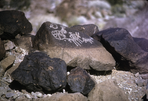
Petroglyphs in the Boulder City Dry Fall Area. The exact location is unknown, but the location is possibly in Keyhole Canyon. Petroglyphs are pictogram and logogram images created by removing part of a rock surface by incising, picking, carving, or abrading. Outside North America, scholars often use terms such as "carving", "engraving", or other descriptions of the technique to refer to such images. Petroglyphs are found world-wide, and are often associated with prehistoric peoples. The word comes from the Greek words petro-, theme of the word "petra" meaning "stone", and glyphein meaning "to carve", and was originally coined in French as pétroglyphe. The term petroglyph should not be confused with petrograph, which is an image drawn or painted on a rock face. Both types of image belong to the wider and more general category of rock art or parietal art. Petroforms, or patterns and shapes made by many large rocks and boulders over the ground, are also quite different. Inukshuks are also uni
Image
Slide of John Lytle at Emigrant (Fremont) Gap on the Old Spanish Trail, California, circa 1960s
Date
1960 to 1969
Archival Collection
Description
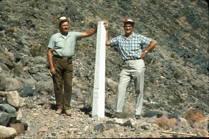
John Lytle (left) and Sherman "Scoop" Garside (right) at Emigrant (Fremont) Gap on the Old Spanish Trail. Emigrant Gap is a gap in a ridge on the California Trail as it crosses the Sierra Nevada, to the west of what is now known as Donner Pass. Here the cliffs are so steep that, back in the 1840s, the pioneers on their way to California had to lower their wagons on ropes in order to continue. The first official effort to mark the Old Spanish Trail across Nevada took place in 1964 when the Governor of Nevada asked Sherwin "Scoop" Garside to design and implement a Centennial project to help commemorate the Silver State's 100th birthday. Garside proposed that an appropriate Centennial project would be to mark the trace of the Old Spanish Trail across southern Nevada. The Governor concurred and directed the Nevada State government to cooperate in the project. Garside and his associate John Lytle brought together a group of friends and supporters to help fund and fabricate the white concrete posts that were used to mark the trace of the Old Spanish Trail across the state. Members of an affiliate of the local Boy Scouts of America Council helped erect thirty-three of these markers across the Mojave Desert in southern Nevada and Eastern California. The markers are inscribed with the legend "The Old Spanish Trail, 1829-1855." There are four Old Spanish Trail Historical Markers located in Nevada. One is located on U. S. 91 in Mesquite, the second is located in Fantasy Park, 1/4 mile east of Las Vegas Boulevard, North and Washington Avenue in Las Vegas, the third is located at Town Center in Blue Diamond, and the fourth is located on State 16 at Mountain Springs Summit. In 2001, the section of the Trail that runs across Nevada from the Arizona border to California (known as the "Old Spanish Trail-Mormon Road Historic District") was placed on the National Register of Historic Places.
Image
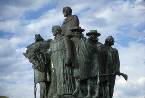
Slide of the This Is The Place Monument, Salt Lake City, Utah, circa 1990s
Date
1990 to 1999
Archival Collection
Description
A statue of early trappers that is inscribed with "This is the place." A view of the left-hand side of the This is the Place Monument. Several individual sculptures make up the full monument. The This is the Place Monument is a historical monument at the This is the Place Heritage Park, located on the east side of Salt Lake City, Utah, at the mouth of Emigration Canyon. It is named in honor of Brigham Young's famous statement in 1847 that the Latter-day Saint pioneers should settle in the Salt Lake Valley. Sculpted between 1939 and 1947 by Mahonri M. Young, a grandson of Brigham Young, it stands as a monument to the Mormon pioneers as well as the explorers and settlers of the American West. It was dedicated by LDS Church President George Albert Smith on 24 July 1947, the hundredth anniversary of the pioneers entering the Salt Lake Valley. It replaced a much smaller monument located nearby.
Image
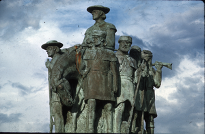
Slide of the This Is The Place Monument, Salt Lake City, Utah, circa 1990s
Date
1990 to 1999
Archival Collection
Description
A view of the right-hand side of the This is the Place Monument. Several individual sculptures make up the full monument. The This is the Place Monument is a historical monument at the This is the Place Heritage Park, located on the east side of Salt Lake City, Utah, at the mouth of Emigration Canyon. It is named in honor of Brigham Young's famous statement in 1847 that the Latter-day Saint pioneers should settle in the Salt Lake Valley. Sculpted between 1939 and 1947 by Mahonri M. Young, a grandson of Brigham Young, it stands as a monument to the Mormon pioneers as well as the explorers and settlers of the American West. It was dedicated by LDS Church President George Albert Smith on 24 July 1947, the hundredth anniversary of the pioneers entering the Salt Lake Valley. It replaced a much smaller monument located nearby.
Image
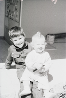
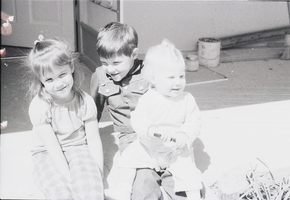
Film transparency of Elbert Edwards' grandchildren, 1976
Date
1976
Archival Collection
Description
Elbert and Mary Edwards' grandchildren. The grandchildren include: Quincy, Lindee, Mindy, Bret, and Jennie.
Image

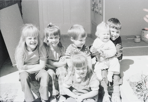
Film transparency of Elbert Edwards' grandchildren, 1976
Date
1976
Archival Collection
Description
Elbert and Mary Edwards' grandchildren. The grandchildren include: Quincy, Lindee, Mindy, Bret, and Jennie.
Image
Film transparency of Elbert Edwards' grandchildren, 1976
Date
1976
Archival Collection
Description
Elbert and Mary Edwards' grandchildren. The grandchildren include: Quincy, Lindee, Mindy, Bret, and Jennie.
Image
Film transparency of Elbert Edwards' grandchildren, 1976
Date
1976
Archival Collection
Description
Elbert and Mary Edwards' grandchildren. The grandchildren include: Quincy, Lindee, Mindy, Bret, and Jennie.
Image