Search Results

Map showing profile of 24-inch cast iron water pipeline for Las Vegas, Nevada, May 20, 1930
Date
Archival Collection
Description
Image
Nevada Poetry Society Records
Identifier
Abstract
The Nevada Poetry Society Records are comprised of the Society's records dating from 1961 to 1973. Society organizer and president, Mildred Breedlove is featured prominently in the collection. Materials include Silver Strings: Nevada Poetry Society Anthology, a collection of poems commemorating Nevada's centennial year, individual poems from members, financial records, correspondence, and newsletters.
Archival Collection
Nevada Research Labs Photographs
Identifier
Abstract
The Nevada Research Labs Photographs (1958-1964) include three folders containing aerial photographic prints depicting flood plains in Nevada and the Nevada Test Site.
Archival Collection

Plat of H.F.M & M addition to city of Las Vegas, Clark County, Nevada, comprising the west 1/2 of N.W. 1/4 Sec. 27, Twp. 20 S., R. 61 E., M.D.B & M, March 8, 1924
Date
Description
Image
Nevada Women's Archives Records
Identifier
Abstract
Records (1994-1999) are comprised of planning documents, newspaper clippings, external communication, and memoranda documenting the establishment and operations of the Nevada Women's Archives at the University of Nevada, Las Vegas. The records primarily document collection materials from the first exhibit created using the Nevada Women's Archive.
Archival Collection

Map showing proposed new 12" well and pipe line changes at Water Springs, Las Vegas, Nevada, circa 1920
Date
Archival Collection
Description
Image

Map of Lincoln County, Nevada and Mohave County, Arizona area, 1892
Date
Description
Image
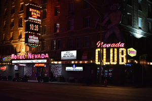
Hotel Nevada and Nevada Club wall and roof mounted signs, Ely, Nevada
Date
Archival Collection
Description
View of the signs for the Hotel Nevada and Nevada Club, including a closeup of a slot machine sign.
501 E Aultman St, Ely, NV 89301
Image
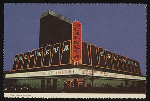
Club Cal Nevada in Reno, Nevada: postcard
Date
Archival Collection
Description
Image

Club Cal Nevada in Reno, Nevada: postcard
Date
Archival Collection
Description
Image