Search Results

Map showing parts of eastern and southeastern Nevada and southwestern Utah, circa 1873
Date
1869
1872 to 1873
Archival Collection
Description
Scale 1:506,880. 1 in. to 8 miles (W 117°30--W 114°45/N 37°20--N 40°00). Relief shown by hachures and spot heights. At top left: 'Explorations & surveys west of the one-hundredth meridian.' At top right: 'Parts of Eastern & Southeastern Nevada & Southwestern Utah. Atlas sheet number 66.' At bottom left: 'Expeditions of 1869, 1872 & 1873.' At bottom right: ' 1st Lieut. Geo. M. Wheeler, Corps of Engineers, com'd'g.' Seal of the War Department, Corps of Engineers, U.S. Army at top center of map. Originally published as part of the geological atlas which is an appendix to the Survey's Report upon United States geographical surveys west of the one hundredth meridian, published in 1876?
Image
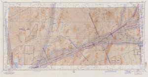
Elko sectional aeronautical chart, September 29, 1959
Date
1959-09-29
Description
52 x 110 cm. Relief shown by gradient tints, contours, and spot heights. Contour interval 1,000 feet. "Aeronautical data on this chart includes data received through Sept. 29, 1959." "Consult appropriate NOTAMS and Radio Facility Charts for supplemental data and current information." "Next edition is scheduled in approximately one year." "Base: Edition of May 1956. Revised Sept. 1958." "Lambert Conformal Conic Projection." "Standard Parallels 33° and 45°." "Elko compiled and printed at Washington, D. C. by the U. S. Coast and Geodetic Survey under authority of the Secretary of Commerce." "Principal sources: U. S. Geological Survey, U. S. Army Corps of Engineers, U. S. Air Force, U. S. Dept. of Agriculture, Civil Aeronautics Administration, and the U. S. Coast and Geodetic Survey." "Base: Edition of May 1956, revised Sept. 1958." "Detailed airport data and other useful information are printed on the back of this chart." Includes text, gradient tints scale and index to adjoining sheets. On verso: text, index map of sectional charts, inset maps of U.S. air defense identification zones and defense area, visual emergency signals, and charts. Original publisher: U.S. Coast and Geodetic Survey, Scale: 1:500,000.
Image
Goldfield Consolidated Mines Company Records
Identifier
MS-00744
Abstract
The Goldfield Consolidated Mines Company Records (1904-1930) consist of correspondence, invoices, receipts with voucher checks, mining leases, insurance policies, payroll accounts, published notices and articles. Also included is a monthly Goldfield Consolidated Mines reports ledger from February 1914 to October 1916 for mines located in the south central Nevada area. The collection primarily dates from 1904, before the consolidation when the boom in Goldfield was beginning in earnest, until 1919, when the company ceased its operations in Goldfield, although there are a few records post-1919 as the company continued to exist after the mines and mill closed down.
Archival Collection
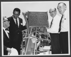
Photograph of Powell Commemorative Ceremony, Lake Powell, June 19, 1969
Date
1969-06-19
Archival Collection
Description
The unveiling of a plaque dedicated to the memory of Major John Wesley Powell at a Powell Commemorative Ceremony on Lake Powell. From left to right, the individuals identified are Governor Jack Williams of Arizona; Chairman Raymond Nakai of the Navajo Tribal Council; James R. Smith, Assistant Secretary of the Interior; and Governor Calvin L. Rampton of Utah. The plaque reads as follows: "Lake Powell; Major John Wesley Powell led scientific exploration parties down the Green and Colorado Rivers in 1869 and in 1871-72. Years later Powell became a leader in government science programs, headed the U. S. Geological Survey and the Bureau of American Ethnology, and advocated enlightened land and water conservation policies which resulted in the passage of the Reclamation Act of 1902. In commemoration of his courage, his wisdom, and his years of public service, the reservoir behind Glen Canyon Dam as been named Lake Powell."
Image
Ryan, George Kelly, 1911-1977
George Kelly Ryan was a geological engineer, prospector, and land use advisor who lived in Las Vegas, Nevada from 1959 until his death. He served in the Marines during World War II and was a member of the Disabled American Veterans. George was also active in the Nevada Mining Council and the First United Methodist Church. George was born June 3, 1911 in Salt Lake City, Utah. His father was Archer De Vol "Archie" Ryan and his mother was Maggie Kelly.
Person
Marjorie Barrick Museum of Natural History
The Marjorie Barrick Museum of Natural History was founded as the Museum of Natural History by Richard H. Brooks in 1967 in Las Vegas, Nevada. Brooks was then the director of the Desert Research Institute (DRI). The museum was owned by DRI until the ownership was transferred to the University of Nevada, Las Vegas in 1969. The museum's primary operations included exhibitions that displayed artifacts and artworks of the archaeology, history, and geology of Southern Nevada.
Corporate Body