Copyright & Fair-use Agreement
UNLV Special Collections provides copies of materials to facilitate private study, scholarship, or research. Material not in the public domain may be used according to fair use of copyrighted materials as defined by copyright law. Please cite us.
Please note that UNLV may not own the copyright to these materials and cannot provide permission to publish or distribute materials when UNLV is not the copyright holder. The user is solely responsible for determining the copyright status of materials and obtaining permission to use material from the copyright holder and for determining whether any permissions relating to any other rights are necessary for the intended use, and for obtaining all required permissions beyond that allowed by fair use.
Read more about our reproduction and use policy.
I agree.Information
Digital ID
Permalink
Details
Member of
More Info
Rights
Digital Provenance
Publisher
Transcription
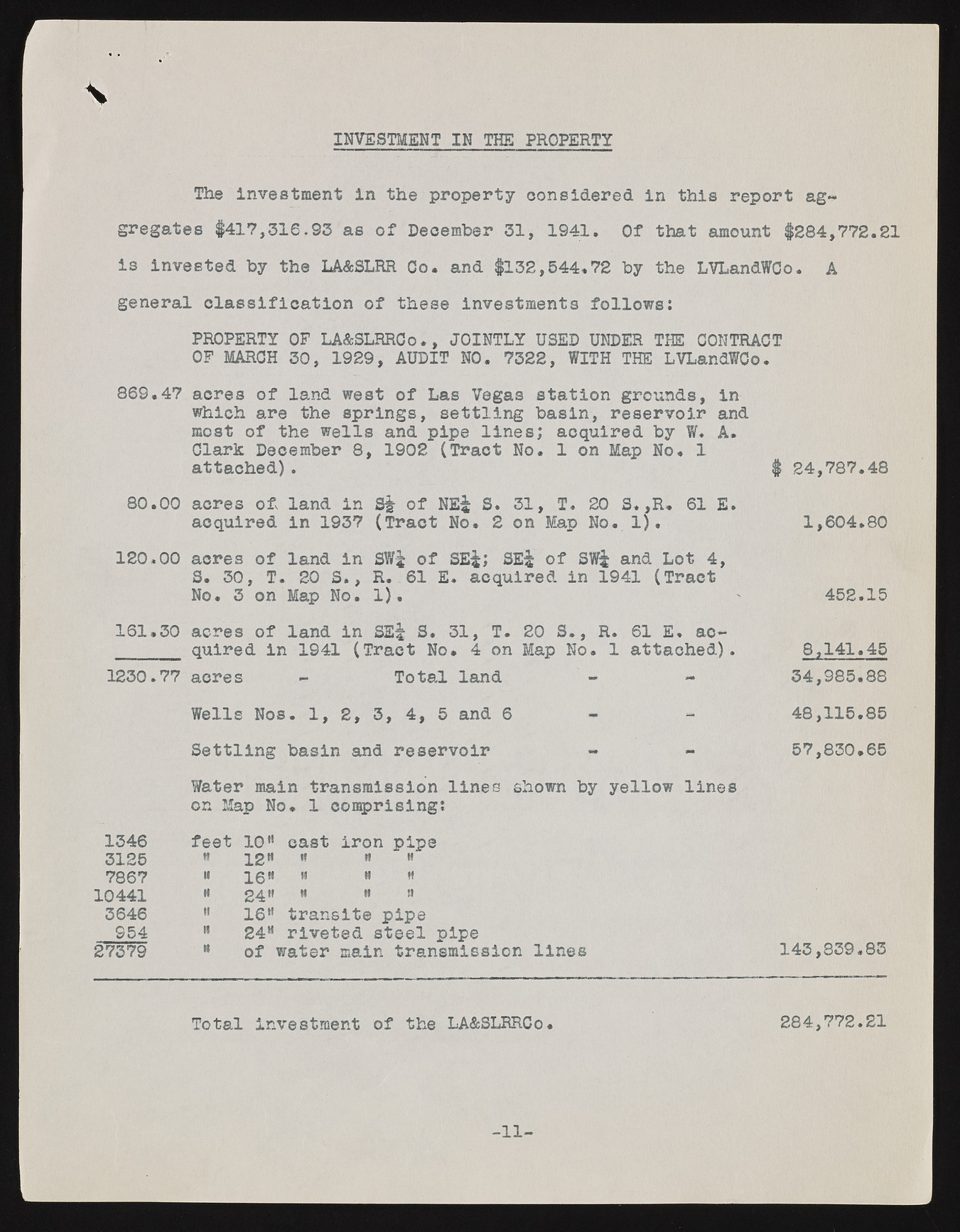
\ INVESTMENT IN THE PROPERTY The investment in the property considered in this report aggregates #417,316.93 as of December 31, 1941. Of that amount #284,772.81 is invested by the LA&SLRR Go. and #132,544.72 by the LVLandWCo. A general classification of these investments follows: PROPERTY OF LA&SLRRCo., JOINTLY USED UNDER THE CONTRACT OF MARCH 30, 1929, AUDIT NO. 7322, WITH THE LVLandWCo. 869.47 acres of land west of Las Vegas station grounds, in which are the springs, settling basin, reservoir and most of the wells and pipe lines; acquired by W. A. Clark December 8, 1902 (Tract No. 1 on Map No. 1 attached). # 24,787.48 80.00 acres of land in S§ of NE^ S. 31, T. 20 S.,R. 61 E. acquired in 1937 (Tract No. 2 on Map No. 1). 1,604.80 120.00 acres of land in SW-£ of SE^; SE^ of SWi and Lot 4, S. 30, T. 20 S., R. 61 E. acquired in 1941 (Tract No. 3 on Map No. 1). 452.15 161.30 acres of land in SEf S. 31, T. 20 S., R. 61 E. acquired in 1941 (Tract No. 4 on Map No. 1 attached). 8,141.45 1230.77 acres - Total land - - 34,985.88 Wells Nos. 1, 2, 3, 4, 5 and 6 48,115.85 Settling basin and reservoir 57,830.65 Water main transmission lines shown by yellow lines on Map No. 1 comprising: 1346 feet lol cast iron pipe 3125 « 2.2n 9 it h 7867 II igti II H « 10441 ii 2411 m « n 3646 " 16H transits pipe 954 B 24“ riveted steel pipe 27379 " of water main transmission lines 143,839.83 Total investment of the LA&SLRRCo. 284,772.21 -11-

