Copyright & Fair-use Agreement
UNLV Special Collections provides copies of materials to facilitate private study, scholarship, or research. Material not in the public domain may be used according to fair use of copyrighted materials as defined by copyright law. Please cite us.
Please note that UNLV may not own the copyright to these materials and cannot provide permission to publish or distribute materials when UNLV is not the copyright holder. The user is solely responsible for determining the copyright status of materials and obtaining permission to use material from the copyright holder and for determining whether any permissions relating to any other rights are necessary for the intended use, and for obtaining all required permissions beyond that allowed by fair use.
Read more about our reproduction and use policy.
I agree.Information
Digital ID
Permalink
Details
Member of
More Info
Rights
Digital Provenance
Publisher
Transcription
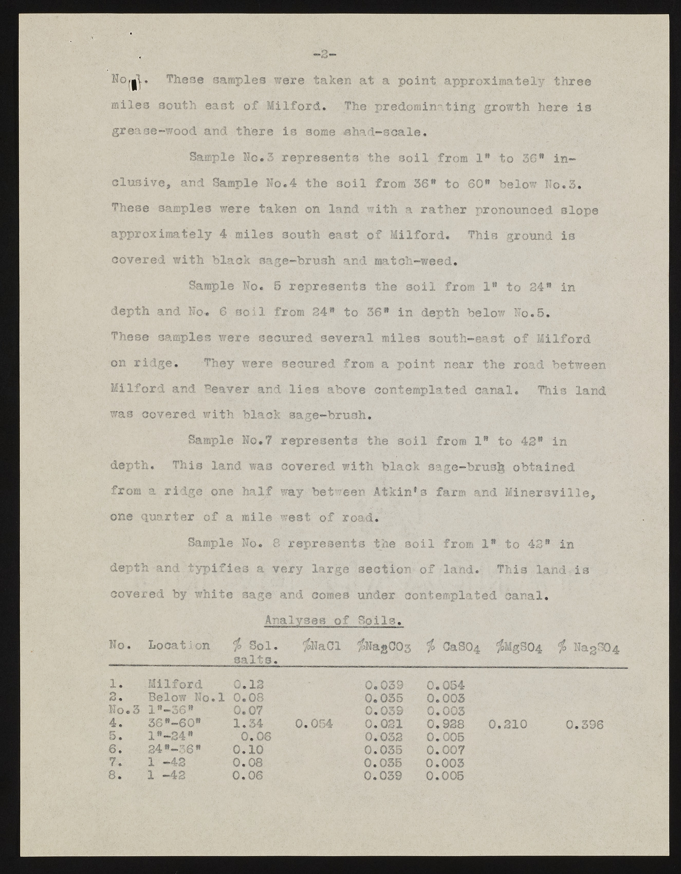
Nwl, These samples were taken at a point approximately three miles south east of Milford. The predominating growth here is grease-wood and there is some shad-scale. Sample No.3 represents the soil from lw to 30" inclusive, and Sample No.4 the soil from 36" to 60" below Ho.3. These samples were taken on land with a rather pronounced slope approximately 4 miles south east of Milford. This ground is covered with black sage-brush and match-weed. Sample No. 5 represents the soil from 1" to 24" in depth and No. 6 soil from 24" to 36" in depth below No.5. These samples were secured several miles south-east of Milford on ridge. They were secured from a point near the road between Milford and Beaver and lies above contemplated canal. This land was covered with black sage-brush. Sample No.7 represents the soil from 1" to 42" in depth. This land was covered with black sagc-brus^ obtained from a ridge one half way between Atkin*s farm and Minersville, one quarter of a mile west of road. Sample No. 8 represents the soil from 1" to 42” in depth and typifies a very large section of land. This land is covered by white sage and comes under contemplated canal. Analyses of Soils, No. Location > Sol. salts. iNaOl /fjNagCOg b CaS04 ;&MgS04 ct b NagS04 1. Milford 0.12 2 • Below No.l 0.08 No. 3 1"—36" 0.07 4. 36"-60" 1.34 5. l"-34" 0.06 6. 24"-6" 0.10 7. 1 —42 0.08 8. 1 -42 0.06 0.039 0.035 0.039 0.021 0.032 0.035 0.035 0.039 0.054 0.003 0.003 0.928 0.005 0.007 0.003 0.005 0.210 0.054 0.396

