Copyright & Fair-use Agreement
UNLV Special Collections provides copies of materials to facilitate private study, scholarship, or research. Material not in the public domain may be used according to fair use of copyrighted materials as defined by copyright law. Please cite us.
Please note that UNLV may not own the copyright to these materials and cannot provide permission to publish or distribute materials when UNLV is not the copyright holder. The user is solely responsible for determining the copyright status of materials and obtaining permission to use material from the copyright holder and for determining whether any permissions relating to any other rights are necessary for the intended use, and for obtaining all required permissions beyond that allowed by fair use.
Read more about our reproduction and use policy.
I agree.Information
Digital ID
Permalink
Details
More Info
Rights
Digital Provenance
Publisher
Transcription
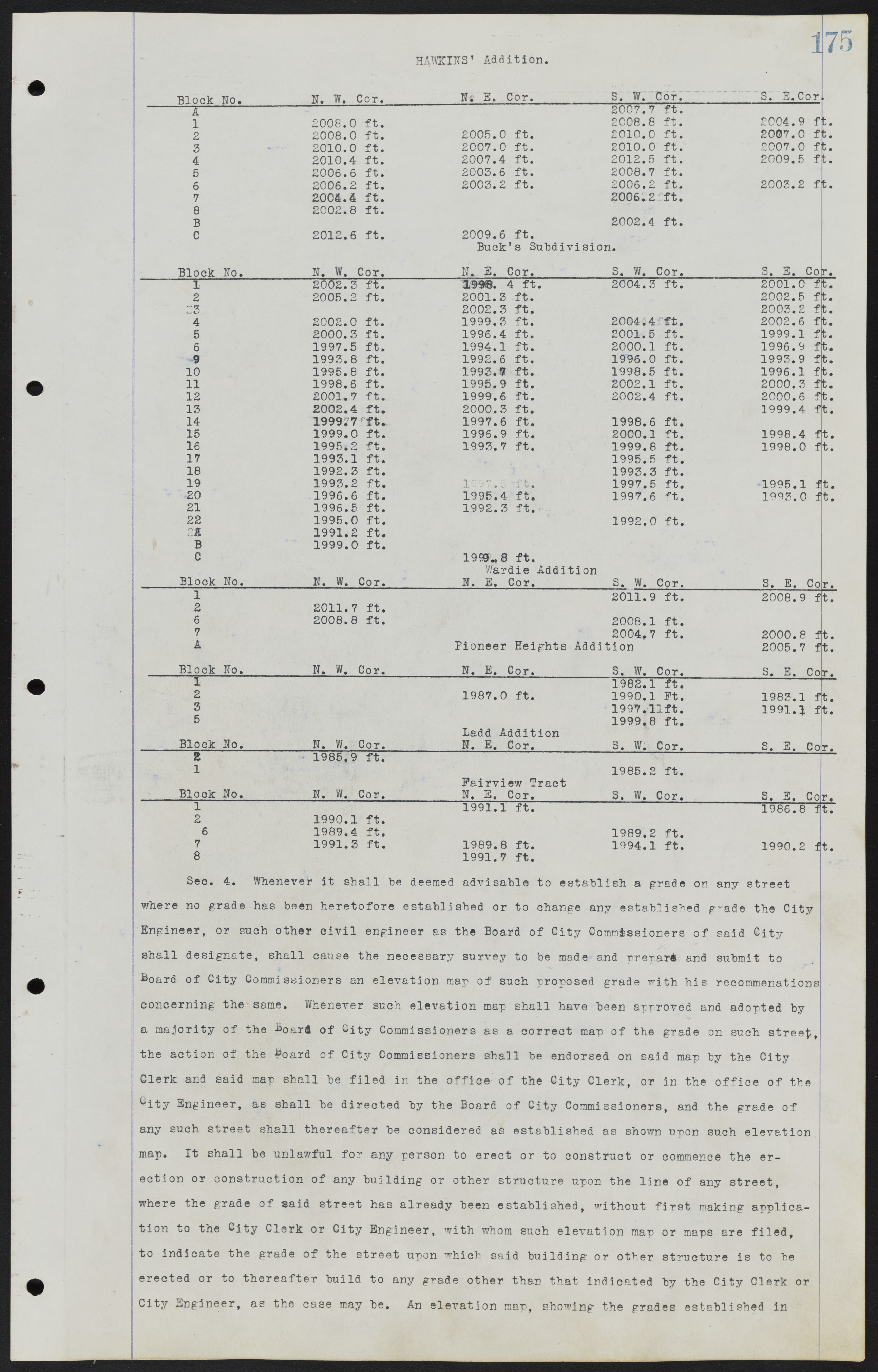
175 HAWKINS' Addition. Block No. N. W. Cor.___________ N. E. Cor. S. W. Cor. S. E. Cor. A 2007.7 1 2008.0 ft. 2008.8 2 2008.0 ft. 2005.0 ft. 2010.0 ft. 2007.0 ft. 3 . 20100. ft. 2007.0 ft. 2010.0 ft. 2007.0 ft. 4 2010.4 ft. 2007.4 ft. 2012.5 ft. 2009.5 ft. 5 2006.6 ft. 2003.6 ft. 2008.7 ft. 6 2006.2 ft. 2003.2 ft. 2006.2 ft. 2003.2 ft. 7 2004.4 ft. 2006.2 ft. 8 2002.8 ft. B 2002.4 ft. C 2012.6 ft. 2009.6 ft. Buck's Subdivision. Block No. N. W. Cor. N. E. Cor. S. W. Cor. S. E. Cor. 1 2002.3 ft. 1998.4 ft. 2004.3 ft. 2001.0 ft. 2 2005.2 ft. 2001.3 ft. 2002.5 ft. 3 2002.3 ft. 2003.2 ft. 4 2002.0 ft. 1999.3 ft. 2004.4 ft. 2002.6 ft. 5 2000.3 ft. 1996.4 ft. 2001.5 ft. 1999.1 ft. 6 1997.5 ft. 1994.1 ft. 2000.1 ft. 1996.9 ft. 9 1993.8 ft. 1992.6 ft. 1996.0 ft. 1993.9 ft. 10 1995.8 ft. 1993.7 ft. 1998.5 ft. 1996.1 ft. 11 1998.6 ft. 1995.9 ft. 2002.1 ft. 2000.3 ft. 12 2001.7 ft. 1999.6 ft. 2002.4 ft. 2000.6 ft. 13 2002.4 ft. 2000.3 ft. 1999.4 ft. 14 1999.7 ft. 1997.6 ft. 1998.6 ft. 15 1999.0 ft. 1996.9 ft. 2000.1 ft. 1998.4 ft. 16 1995.2 ft. 1993.7 ft. 1999.8 ft. 1998.0 ft. 17 1993.1 ft. 1995.5 ft. 18 1992.3 ft. 1993.3 ft. 19 1993.2 ft. 1997.5 ft. 1997.5 ft. 1995.1 ft. 20 1996.6 ft. 1995.4 ft. 1997.6 ft. 1993.0 ft. 21 1996.5 ft. 1992.3 ft. 22 1995.0 ft. 1992.0 ft. A 1991.2 ft. B 1999.0 ft. C 1999.8 ft. Wardie Addition Block No. N. W. Cor. N. E. Cor. S. W. Cor. S. E. Cor. 1 2011.9 ft. 2008.9 ft. 2 2011.7 ft. 6 2008.8 ft. 2008.1 ft. 7 2004.7 ft. 2000.8 ft. A Pioneer Heights Addition 2005.7 ft. Block No. N. W. Cor. N. E. Cor. S. W. Cor. S. E. Cor. 1 1982.1 ft. 2 1987.0 ft. 1990.1 ft. 1983.1 ft. 3 1997.1 ft. 1991.1 ft. 5 1999.8 ft. Ladd Addition ______Block No.__________N. W. Cor.____________N. E. Cor._________ S. W. Cor.__________ S. E. Cor. 2 1985.9 ft. 1 1985.2 ft. Fairview Tract Block No. N. W. Cor. N. E. Cor. S. W. Cor. S. E. Cor. 1 1991.1 ft. 1986.8 ft. 2 1990.1 ft. 6 1989.4 ft. 1989.2 ft. 7 1991.3 ft. 1989.8 ft. 1994.1 ft. 1990.2 ft. 8 1991.7 ft. Sec. 4. Whenever it shall be deemed advisable to establish a grade on any street where no grade has been heretofore established or to change any established grade the City Engineer, or such other civil engineer as the Board of City Commissioners of said City shall designate, shall cause the necessary survey to be made and prerare and submit to Board of City Commissioners an elevation map of such proposed grade with his recommendations concerning the same. Whenever such elevation map shall have been approved and adopted by a majority of the Board of City Commissioners as a correct map of the grade on such street, the action of the Board of City Commissioners shall be endorsed on said map by the City Clerk and said map shall be filed in the office of the City Clerk, or in the office of the City Engineer as shall be directed by the Board of City Commissi oners, and the grade of any such street shall thereafter be considered as established as shown upon such elevation map. It shall be unlawful for any person to erect or to construct or commence the erection or construction of any building or other structure upon the line of any street, where the grade of said street has already been established, without first making application to the City Clerk or City Engineer, with whom such elevation map or maps are filed, to indicate the grade of the street upon which said building or other structure is to be erected or to thereafter build to any grade other than that indicated by the City Clerk or City Engineer, as the case may be. An elevation map, showing the grades established in

