
Search the Special Collections and Archives Portal

Search Results

Display    Results Per Page
Displaying results 1 - 10 of 17

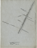
Map showing water pipeline serving H. C. Wheeler, Arden, Nevada, November 1929

Date

1929-11

Description

Hand-drawn map. '2-W-214' hand-printed in lower right corner. Scale: 1" = 400'.

Image

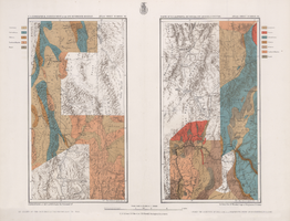
Maps of geographical surveys of parts of California, southeastern Nevada, Arizona and southwestern Utah, made under the command of George M. Wheeler, 1872-1873

Date

1872 to 1873

Description

At top of plate: 'U.S. geographical surveys west of the one-hundredth meridian. Parts of California, S.E. Nevada, Arizona & S.W. Utah.' At bottom of plate: 'Expeditions of 1872 & 1873, under the command of 1st Lieut. Geo. M. Wheeler, Corps of Engineers, U.S. Army.' 'G. K. Gilbert, A. R. Marvine, E. E. Howell, geological assistants.' 'By order of The Honorable The Secretary of War, under the direction of Brig. Gen. A. A. Humphries, Chief of Engineers, U.S. Army.' Published by Government Printing Office. 2 map sections on 1 sheet. Scale: 1 inch to 8 miles.

Image

Map showing parts of eastern and southeastern Nevada and southwestern Utah, circa 1873

Date

1869
1872 to 1873

Description

Scale 1:506,880. 1 in. to 8 miles (W 117°30--W 114°45/N 37°20--N 40°00). Relief shown by hachures and spot heights. At top left: 'Explorations & surveys west of the one-hundredth meridian.' At top right: 'Parts of Eastern & Southeastern Nevada & Southwestern Utah. Atlas sheet number 66.' At bottom left: 'Expeditions of 1869, 1872 & 1873.' At bottom right: ' 1st Lieut. Geo. M. Wheeler, Corps of Engineers, com'd'g.' Seal of the War Department, Corps of Engineers, U.S. Army at top center of map. Originally published as part of the geological atlas which is an appendix to the Survey's Report upon United States geographical surveys west of the one hundredth meridian, published in 1876?

Image

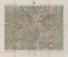
Map of economical features of Southwest Colorado, San Juan mining region, circa 1877

Date

1872 to 1880

Description

37 x 49 cm. Relief shown by hachures and spot heights. "Atlas sheet no. 61(C)." "Expeditions of 1874 & 1875 under the command of 1st. Lieut. Geo. M. Wheeler, Corps of Engineers, U.S. Army." "Louis Nell, del." "By order of the honorable the Secretary of War." "Under the direction of Brig. General A. A. Hunphreys, Chief of Engineers, U. S. Army." Original publisher: U.S. Geographical Surveys West of the 100th Meridian, Scale: 1 inch to 2 miles or 1: 126720.

Image

Map of economic features of parts of southern Colorado and northern New Mexico Atlas sheet no. 70(A.), May 5, 1877

Date

1877-05-07

Description

37 x 49 cm. Relief shown by hachures and spot heights. Prime meridians: Greenwich and Washington, D.C. "Atlas sheet no. 70(A)." "Issued May 7th, 1877." "Expeditions of 1874, 1875 & 1876 under the command of 1st. Lieut. Geo. M. Wheeler, Corps of Engineer, U.S. Army." "Weyss, Herman & Mahlo, del." "By order of the honorable the Secretary of War." "Under the direction of Brig. General A. A. Hunphreys, Chief of Engineers, U. S. Army." Original publisher: U.S. Geographical Surveys West of the 100th Meridian, Scale: 1 inch to 4 miles or 1: 253440.

Image

Map showing detailed topography of the country traversed by the reconnaissance expedition through southern & southeastern Nevada, 1869 (reproduction)

Date

1869

Description

At top of map: 'Reconnaissance Maps, Department of California.' 'In charge of, Lieut. Geo. M. Wheeler, U.S. Engineers; assisted by Lieut. D.W. Lockwood, Corps of Engineers,U.S.A., 1969.' 'P.W. Hamel, chief topographer and draugthsman.' 'Traced 11-13-67.' 'BGS'; the G is enclosed in an arrowhead shape. 'Officially compiled and published at the Engineer Office, Head Quarters Department of California in 1869 and 70 by order of Brigadier General E.O.C. Ord. Comm'dg. [signed] Geo. M. Wheeler, Lieutenant of Engineers In Charge, Head Quarters Dept. of Cal. Oct. 26th, 1870.' Includes information from railroad maps, the United States Geological Survey of the 40th parallel and from Lieutenant Ives' explorations along the Colorado. Map includes camps, astronomical stations, good and bad wagon roads, trails, springs, settlements, mining districts, state and county boundaries and the watershed between the Humboldt and Colorado Basin. Shows most of eastern half of Nevada. Relief shown by hachures and spot heights. Scale indeterminable. (W 117°00´--W 113°00´/N 41°45´--N 35°45´). Series: Reconnaissance maps. Military map / Department of Californiano. 1. Reproduction. Map is printed in purple. Scale of original map: [1:760,320]. 1 in. to approx. 12 miles. Includes dots hand-colored with red pencil marking Indian rancherias.

Image

Map showing detailed topography of the country traversed by the reconnaissance expedition through southern & southeastern Nevada, 1869

Date

1869

Description

At top of map: 'Reconnaissance Maps, Department of California.' In lower right corner: 'Photolith. by the N.Y. Lithg. Engrg. & Prtg. Co.' 'In charge of, Lieut. Geo. M. Wheeler, U.S. Engineers; assisted by Lieut. D.W. Lockwood, Corps of Engineers,U.S.A., 1969.' 'P.W. Hamel, chief topographer and draugthsman.' 'Officially compiled and published at the Engineer Office, Head Quarters Department of California in 1869 and 70 by order of Brigadier General E.O.C. Ord. Comm'dg. [signed] Geo. M. Wheeler, Lieutenant of Engineers In Charge, Head Quarters Dept. of Cal. Oct. 26th, 1870.' Includes information from railroad maps, the United States Geological Survey of the 40th parallel and from Lieutenant Ives' explorations along the Colorado. Map includes camps, astronomical stations, good and bad wagon roads, trails, springs, settlements, mining districts, state and county boundaries and the watershed between the Humboldt and Colorado Basin. Shows most of eastern half of Nevada. Relief shown by hachures and spot heights. Scale: [1:760,320]. 1 in. to approx. 12 miles. (W 117°00´--W 113°00´/N 41°45´--N 35°45´). Series: Reconnaissance maps. Military map / Department of Californiano. 1.miles. Library's copy has counties hand-outlined in colored markers.

Image

Map of explorations and surveys south of the Central Pacific Railroad made by the U.S. Army Corps of Topographical Engineers, 1871

Date

1871

Description

'Preliminary topographical map embracing in skeleton a portion only of the notes from surveys made in accordance with Par.II Special Orders No. 109 War Dept., March 18th, 1871 and letter of instructions of Brig. General A.A. Humphreys, Chief of Eng'rs. dated March 23rd, 1871. Conducted under the immediate direction of 1st Lieutenant Geo. M. Wheeler, Corps of Eng'rs., assisted by 1st Lieutenant D.W. Lockwood, Corps of Eng'rs. and 2nd Lieutentant D.A. Lyle, 2nd U.S. Artillery, during the summer and fall of 1871. Louis Nell, chief topographer and draughtsman.'' At head of map: 'Explorations in Nevada and Arizona. U.S. Engineer Department.' In lower left corner: 'Note: This map is a hasty and partial compilation from the topographical data already received, many still remaining en route. Upon it is projected in skeleton the groundwork of the area examined. All points except the prominent astronomical positiions are subject to lsight modification upon the final map.' Shows area through central Nevada, eastern California, and central Arizona. Relief shown by hachures. Published by the War Dept. Scale [ca. 1:1,520,640]. 1 in. to 24 miles (W 118°--W 109°/N 41°--N 32°).

Image

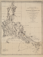
Geological reconnaissance map of Nevada south of the 40th parallel and adjacent California, 1903

Date

1903

Description

'Compiled from all available information by J.E. Spurr. Topographic base chiefly adapted from the maps of the Wheeler Survey.' 'U.S. Geological Survey, Bulletin No. 208, Pl. 1.' 'A. Hoen & Co. Lith. Baltimore, MD.' Relief shown by hachures and spot heights. Scale [ca. 1:950,000. 1 inch to approximately 15 miles] (W 120°--W 114°/N 40°--N 36°). Geological Survey bulletin, 208.

Image

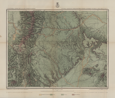
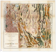
Map of economical features of parts of southern Colorado and northern New Mexico, January 8, 1878

Date

1878-01-08

Description

37 x 49 cm. Relief shown by hachures and spot heights. "Atlas sheet no. 69(B)." "Issued Jan'y 8th 1878." "Expeditions of 1874-1875 & 1877 under the command of 1st. Lieut. Geo. M. Wheeler, Corps of Engineers, U.S. Army." Prime meridians: Greenwich and Washington, D.C. "Weyss, Lang & Herman, del." "By order of the honorable the Secretary of War." "Under the direction of Brig. General A. A. Hunphreys, Chief of Engineers, U. S. Army." Original publisher: U.S. Geographical Surveys West of the 100th Meridian, Scale: 1 inch to 4 miles or 1: 253440.

Image