Search Results

Map showing water connection for Moapa School District No. 17, Moapa, Nevada, August 1920
Date
Archival Collection
Description
Image
Water supply - Fillmore
Date
Archival Collection
Description
Mixed Content

Water - Rate Schedule Volume III
Date
Archival Collection
Description
Text
Handbill announcing water outage, Las Vegas, December 11, 1925
Date
Archival Collection
Description
Notice that the water would be shut off on 11 December 1925 from 7 to 10 a.m.
Text
Sale of water - Naval Training Station
Date
Archival Collection
Description
Text
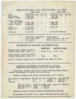
Measurements of water available and consumed in Las Vegas; Per capita water consumption in Fallon, Winnemucca, and Lovelock, circa 1934
Date
Archival Collection
Description
Flow measurements of the Las Vegas Big Spring and Little Spring and well in July 1931 and July 1934. Measurements of reservoir and settling basin on July 17, 1934 and July 19, 1934, before and after passing of city ordinance to reduce water waste. Estimated consumption by refrigeration systems. Estimated per capita water consumption in Las Vegas, Fallon, Winnemucca, and Lovelock.
Text

Map showing plan for water quality management update for wastewater collection systems in the Las Vegas Valley, February 20, 1997
Date
Description
Image
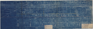
Map showing location of proposed water line to be installed along Los Angeles & Salt Lake Railroad Co. Track No. 8, Las Vegas, Nevada, May 1, 1931
Date
Archival Collection
Description
Label in lower right coner: 'Union Pacific System. Los Angeles & Salt Lake Railroad Co. Form 30, No. 6-4002. Las Vegas, Nevada. Location of proposed water line to be installed along Track No. 8. Scale 1" = 100'. Chief Engineer's Office, L.A. & S.L.R.R. Co., Los Angeles, Caif. May 1, 1931. Dwg. No. 36103.' Handwritten in red pencil on label: 'W.O. 9798.' Accompanies: Work Order Authority for Extensions and Additions to Exisiting Property, Los Angeles & Salt Lake Railroad Co., May 1, 1931. (Box 25 Folder 80-12).
Image
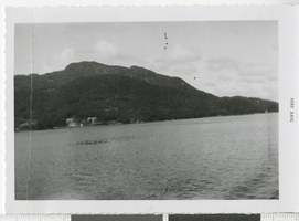
Photograph of a body of water, November 1958
Date
Description
Image
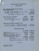
Report on projected cost of water at Las Vegas for year 1930, February 4, 1930
Date
Archival Collection
Description
Summary of the cost of water for the railroad and the water company in Las Vegas in 1930
Text