Search Results
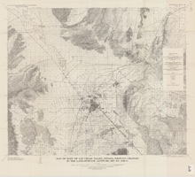
Map of part of Las Vegas Valley, Nevada, showing changes in the land-surface altitude, 1935 to 1940-41
Date
1965
Description
Genre/Form: Topographic map. Scale 1:96,000 (W 115°30´--W 114°45´/N 36°30´--N 36°00´). 1 map ; 58 x 70 cm. Series: Water-supply paper (Washington, D.C.) ; 1780. Relief shown by contours. "After C.R. Longwell (written communication, 1954, fig. 30)." Originally published as plate 12 of Available water supply of the Las Vegas ground-water basin, Nevada, by Glenn T. Malmberg, published by the Geological Survey in 1965 as its Water-supply paper 1780. Includes township and range lines. Interior, Geological Survey
Image

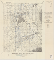
Map showing general geology and areas of artesian flow of the Las Vegas, Pahrump, and Indian Spring Valleys, Clark and Nye Counties, Nevada, 1946
Date
1947
Description
'United States Department of Interior, Geological Survey, Water Resources Bulletin No. 6.' 'State Engineer of Nevada.' Relief shown by contours. Includes township and range lines. Scale [ca. 1:126,720. 1 in.=approx. 2 miles]. Series: Water resources bulletin (Carson City, Nev.)no. 6. Originally published as plate 1 in Ground water in Las Vegas, Pahrump, and Indian Spring Valleys, Nevada : a summary / G. B. Maxey and T. W. Robinson, prepared in cooperation with the United States Department of the Interior, Geological Survey, and published as no. 6 of the Water resources bulletin.
Image
Map of part of Las Vegas Valley, Nevada, showing the approximate piezometric surface in 1912
Date
1965
Description
'Base by U.S. Geological Survey, 1952.' 'Interior--Geological Survey, Washington, D.C.--1965--W63358.' 'Compiled from data published by Carpenter (1915), Kearney (1913), and McWilliams (1913).' Relief shown by contours. Includes township and range lines. Scale 1:62,500 (W 115°15´--W 115°00´/N 36°15´--N 36°00´). Series: Water-supply paper (Washington, D.C.)1780. Originally published as plate 7 of Available water supply of the Las Vegas ground-water basin, Nevada, by Glenn T. Malmberg, published by the Geological Survey in 1965 as its Water-supply paper 1780.
Image
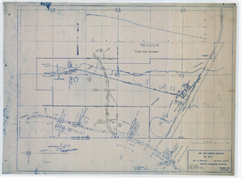
Map showing location of 24" C.I. pipeline in Las Vegas, Nevada, circa 1943
Date
1941 to 1945
Archival Collection
Description
Scale [ca. 1:120]. 1 in. to 10 feet.--Scale [ca. 1:1,200.] 1 in. to 100 feet.--Scale [ca. 1:7,200. 1 in.=approx. 600 feet] --Scale [ca. 1:7,200]. 1 in.=600 feet. Vertical scale [ca. 1:240]. 1 in.=20 feet. 1 map : blueline ; 58 x 74 cm. At head of title: As constructed drawing. "W.O.-8577." "Drawing no. 41092." "City of Las Vegas Highway transcribed from drwg. approved Harlan Brown, City Engineer-Sept. 1943-H.D.A 12/31/43"--Hand-written note. Map of the water pipes for Las Vegas. Includes the buildings in the railroad yard, a detailed map of a section of the pipe, a profile of the 24 inch C.I. pipe, and a map of the point of diversion. Date of detailed map is 5-20-1930. From the Union Pacific Railroad Collection. Los Angeles & Salt Lake Railroad Company, Office of Chief Engineer
Image
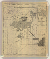
Map of Las Vegas Valley, Clark County, Nevada, circa 1950-1956
Date
1950 to 1956
Description
'Nevada Title Insurance Co. Compiled by Tyson Engineering Co. ... Las Vegas, Nevada. Drawn by A.A. Elliott, Jr.' Shows sewer, water, gas and power lines, water treatment facilities, steam plants, boundaries of the Las Vegas Valley Water District and the Clark County Sanitation District boundaries. Scale [ca. 1:63,360. 1 in. to approx. 1 mile].
Image
Map showing possible industrial users' connections to railroad pipelines in Las Vegas Nevada, circa 1930-1931
Date
1926 to 1936
Archival Collection
Description
Map showing industrial users' connections to railroad pipelines in Las Vegas, Nevada.
Image
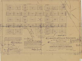
Map of Clark's Las Vegas Townsite, May 8, 1905
Date
1905-05-08
Archival Collection
Description
'Book 1, Page 37.' 'Dated: May 8th, 1905.' Subtitle: 'Being a sub-division of parts of the W.1/2 and the W.1/2 of the N.E.1/4 of Section 34 and the S.1/2 of the S.W.1/4 of Section 27 T.20 S.R. 61 E, Mount Diablo Base and Meridian, Lincoln County, Nevada. A Plat map. Blueline print. Scale [ca. 1:2,400]. 1 in. to 200 feet.
Text

Geologic map of Las Vegas Valley, Nevada, 1982
Date
1982
Description
At top of map:'Department of the Interior, U.S. Geological Survey. Prepared in cooperation with the Clark County Department of Comprehensive Planning. Water supply paper 2320-A, plate 1.' At bottom of map: ' Base from U.S. Geological Survey, 1:100,000, Boulder City, Ariz.-Nev., Las Vegas, Nev.-Calif., Mesquite Lake, Nev.-Calif., 1978; Lake Mead, Nev.-Ariz., 1979. Geology from Malmberg (1965); Longwell and others (1965); Haynes (1967); Bingler (1977); Bell and Smith (1980); Bell (1981); Matti and Bachhuber (1982); and Matti and Morton (1982a, b); modified by R. W. Plume, 1981.' Shows township and range lines. Scale 1:100,000 (W 115°30´--W 115°00´/N 36°30´--N 36°00´). Series: U.S. Geological Survey water-supply paper2320-A. Originally published as plate 1 of Ground-water conditions in Las Vegas Valley, Clark County, Nevada. Part I. Hydrogeologic framework / by Russell W. Plume, published by the U.S. Geological Survey in 1989 as Water-supply paper 2320-A.
Image
Map and basin profiles showing thickness of valley-fill deposits, Las Vegas Valley, Nevada, 1981 (color variation)
Date
1981
Description
At top of map: 'Department of the Interior. U.S. Geological Survey. Water supply paper2320-A, plate 5.' 'Prepared in cooperation with the Clark County Department of Comprehensive Planning.' At bottom of map: 'Base from U.S. Geological Survey, 1:100,000, Boulder City, Ariz.-Nev., Las Vegas, Nev.-Calif., Mesquite Lake, Nev.-Calif., 1978; Lake Mead, Nev.-Ariz., 1979.' 'Geology from Malmberg (1965); Longwell and others (1965); Haynes (1967); Bell and Smith (1980); Bell (1981) and J. R. Harrill, 1976. Thickness of valley-fill deposits by R.W. Plume, 1981.' Includes three profiles. Shows township and range lines. Scale 1:100.000 (W 115°30´--W 115°00´/N 36°30´--N 36°00´). Series: U.S. Geological Survey water-supply paper, 2320-A. Originally published as plate 5 of Ground-water conditions in Las Vegas Valley, Clark County, Nevada. Part I. Hydrogeologic framework / by Russell W. Plume, published by the U.S. Geological Survey in 1989 as Water-supply paper 2320-A.
Image

Map of Las Vegas Valley, Clark County, Nevada, October 1, 1940
Date
1940-10-01
Archival Collection
Description
'Compiled by C.D. Baker, Civil Engineer, State Water Right Surveyor, Mineral Surveyor, Gen. Land Office, Las Vegas, Clark County, Nevada. Oct. 1, 1940.' Yellow lines show boundary of the proposed water district; green lines show boundary of the city of Las Vegas; red line shows the Union Pacific Railroad route.
Image