
Search the Special Collections and Archives Portal

Search Results

Display    Results Per Page
Displaying results 71 - 80 of 128

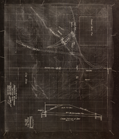
Topographic map showing proposed reservoir for the Las Vegas Rancho, August 4, 1931

Date

1931-08-04

Description

'Chief Engineers Office, Los Angeles, Calif. August 4, 1931. Scale: 1"=100'. Drawn by L.P.D. 1"=10'.' Accompanies: Letter from R. L. Adamson to F. H. Knickerbocker, August 18, 1931 (Folder 6B: 18-1-9).

Image

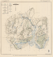
Generalized hydrogeologic map of lower Moapa-Lake Mead area, Clark County, Nevada, 1968

Date

1968

Description

'Hydrogeology by F.E. Rush, 1968. Geology adapted from Longwell and others 1965.' In lower left corner: ' Base: U.S. Geological Survey 1:250,000 topographic series; Las Vegas (1954).' At top of map: 'United States Department of the Interior, Geological Survey. Department of Conservation and Natural Resources, State of Nevada.' Relief shown by contoursIncludes township and range lines. Scale 1:250,000 (W 115°00´--W 114°15´/N 36°30´--N 36°15´). Series: Water resources-reconnaissance series report . Originally published as plate 1 in Water-resources appraisal of the lower Moapa-Lake Mead area, Clark County, Nevada / by F. Eugene Rush, published by State of Nevada Dept. of Conservation and Natural Resources in 1968 in volume 50 of the serial Water resources-reconnaissance series report.

Image

Map of Boulder Dam area and Las Vegas, Nevada, October 7, 1930

Date

1930-10-07

Description

'F.V. Owen, publisher ... Los Angeles, California. Topography by C.H. Fenner, C.E. Decorations by L.J. Bergère. Gov't. data, H.A. Shamberger, C.E. Copyright, 1930, by F.V. Owen.' At bottom right of map: 'Dated Oct. 7th, 1930.' Relief shown by contours and spot heights. Contour lines are 100 feet. Incudes six hand-colored illustrations showing local points of interest. Includes information on Hoover Dam, and chart of mileages from Las Vegas. Scale [ca. 1:63,360]. 1 inch to 1 mile

Text

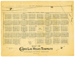
Map of Clark's Las Vegas Townsite, Lincoln County, Nevada, May 10, 1905

Date

1905-05-10

Description

Scale: 1" = 100'. 1 map ; 28 x 22 cm. Verso of map is an announcement of the auction to be held May 15, 1905, for lots in the Las Vegas townsite. Pricing and lot information is included, as well as specials for railway tickets to Las Vegas from Los Angeles and Salt Like City. Las Vegas Land and Water Company

Text

Plan of proposed new well pipe and fittings for Las Vegas, Nevada, 1936

Date

1936

Description

Blueprint. Written on back of map:: 'Purposed [sic] new transmission lines--1936--transits.' Las Vegas Land and Water Company?

Image

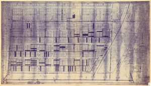
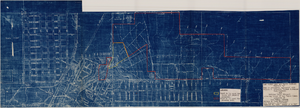
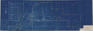
Plat of original townsite of Las Vegas, Clark County, Nevada, November 25, 1927

Date

1927-11-25

Description

Subtitle: 'On N 1/2 of SW 1/4 section 27, T 20 S, R 61 E, M.D. Mer. showing cast iron water mains. Including location and distances of valves, fire hydrants, house connections, etc. Constructed by Las Vegas Land &Water Company. Construction completed Nov. 25-1927. Cast iron pipe system throughout made at Provo, Utah by Pacific States Cast Iron Pipe Company. R.N. Clark, Construction Engineer. Map and survey made by J.T. McWilliams, C.E., Las Vegas, Nev.' Map shows ownership of some parcels of land. Scale [ca. 1:960]. 1 inch to 80 feet. Blueline print. Plat map.

Image

Map of Las Vegas, Nevada, annotated to show different soil types, September 2, 1948

Date

1948-09-02

Description

'Types of soil as determined by James M. Montgomery for use in appraisal. (Copy). LRM 7/10/52'--handwritten in blue pencil in lower right corner of map. 'September 2, 1947. Revised September 2, 1948.' Soil was designated as badly corrosive, mildly corrosive, or non-corrosive by hand-drawn colored lines and hand-printed labels. Soil was surveyed to measure its effect on water pipes. Scale [ca. 1:7,200] 1 in.=600 feet.

Image

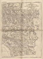
General map showing approximate location of better known springs and wells in the Mohave and adjacent deserts, southeastern California and southwestern Nevada, circa 1908-1909

Date

1905 to 1912

Description

At top of map: 'U.S. Geological Survey, George Otis Smith, Director. Water-supply paper no. 224, pl. 1.' 'Topography compiled from U.S. Geographical Survey atlas sheets,Perris' map of Southern California and other sources.' Relief shown by hachures. Shows township and range grid. Covers the area from Bishop south to the Mexican border, from Long Beach and San Diego to the Arizona border, and the southern part of Nevada, from Beatty and Mesquite south. Scale [ca. 1:1,140,480. 1 in. to approx. 18 miles] (W 118°00´- -W 114°00´/N 37°00´--N 32°32´). Series: Water-supply paper (Washington, D.C.)224. Map is plate 1 from the U.S. Geological Survey Water-supply paper 224.

Image

Map to accompany agreement with Willie T. Stewart, Vernon E. Bunker, Earl Leavitt and William Udell Stewart covering lease of Las Vegas Ranch property at Las Vegas, Nevada, January 31, 1951

Date

1951-01-31

Description

'Las Vegas Land and Water Company, Exhibit A.' 'Office of Vice President, Los Angeles, Califormia. January 31, 1951.' Accompanies document: "N"L.D. 2454 (text of lease of the Las Vegas Ranch) (Box 11 Folder W18-1-12). Scale: 1" = 600'.

Image

Map to accompany agreement with Willie T. Stewart covering lease of land at Las Vegas, Nevada, August 10, 1943

Date

1943-08-10

Description

'Las Vegas Land and Water Company.' 'Office of Vice President, Los Angeles, California, August 10, 1943.' Relief shown by contours. Cadastral map. Scale [ca. 1:7,200]. 1 in.=600 feet..

Image