Search Results
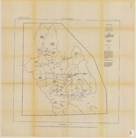
Map showing estimated average recharge to and discharge from ground-water reservoirs by basins, and hydraulic potential in Clark and Nye counties, Nevada, 1963
Date
1963
Description
'T.E. Eakin, S.L. Schoff, and P. Cohen, 1963.' 'Department of the Interior, United States Geological Survey, TEI-833.' 'Prepared in cooperation with the U.S. Atomic Energy Commission.' Scale 1:500,000 (W 117°30´--W 115°00´/N 38°30´--N 36°30´). Originally published as figure 2 in Regional hydrology of a part of southern Nevada : a reconnaissance / by Thomas E. Eakin, Stuart L. Schoff, and Philip Cohen, published by the U.S. Geological Survey in 1963 as number 833 of the Trace elements investigation report.
Image
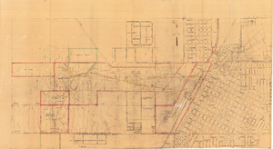
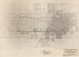
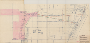
Map of Las Vegas showing areas owned by the Union Pacific Railroad Company, water pipes and other water utilities, circa 1942
Date
1938 to 1946
Archival Collection
Description
Map showing downtown Las Vegas and tracts to the west showing water supply lines, wells, springs, and settling basins. Various areas outlined in red and yellow. Scale [ca. 1:7,200] 1 in.=600 feet. Cadastral map. Blueline print. Areas owned by railroad outlined by hand in different colored markers. Library's copy includes hand-written calculations.
Image
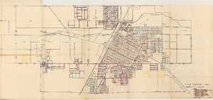
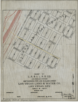
Map showing various facilities of the Las Vegas Land and Water Company, March 1, 1953
Date
1953-03-01
Archival Collection
Description
'Exhibit C.' 'March 1, 1953.' 'I-67.' Scale [ca. 1:7,200] 1 in.=600 feet. Map shows facilities [mainly water-pipes] of Las Vegas Land and Water Company completed and those under construction as of September 1, 1952, and facilities which were commenced after September 1, 1952, and prior to March 1, 1953. Map made as part of the papers for the sale of Las Vegas Land and Water Company facilities to the Las Vegas Valley Water District. Shows township and range lines. Library's copy has hand-written notes in pencil. Las Vegas Land and Water Company?
Image
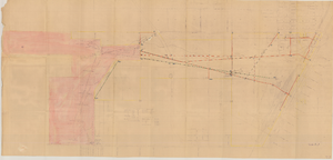
Map of Las Vegas Valley Water District, December 29, 1952
Date
1952-12-29
Archival Collection
Description
'Exhibit A.' 'Dec. 29, 1952.' 'I-128.' Scale [ca. 1:3,600]. 1 in.=300 feet. Shows water pipelines, other parts of the water system, and power lines to be removed or relocated when land is sold to the Las Vegas Valley Water District. Shows land to be sold and lists power requirements for water system. Includes township and range lines. Library's copy includes hand-written notations and calculations. Los Angeles & Salt Lake Railroad Company, Office of Vice President?
Image
Map showing water pipelines, Las Vegas, Nevada, January 15, 1914
Date
1914-01-15
Archival Collection
Description
'S.P.L.A.&S.L.R.R., Los Angeles Division.' 'Jan. 15, 1914.' Includes other parts of water utilities besides pipelines such as sump pumps and water tanks. Scale varies. Blueprint. Library's copy includes hand-written notes.
Image
Map to accompany agreement with Las Vegas Land and Water Company covering furnishing of water by UPRRCo. to LVL&WCo. at Las Vegas, Nevada, October 4, 1950
Date
1950-10-04
Archival Collection
Description
'Los Angeles & Salt Lake Railroad Company, Union Pacific Railroad Company, Exhibit A.' 'Office of Vice President-LVL&WCompany, Los Angeles, California, October 4, 1950.'
Image
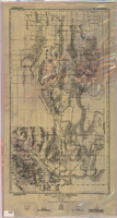
Map of a part of southern Nevada showing ground-water conditions, 1914
Date
1914
Description
At bottom of map: 'Base compiled from plane-table sheets, topographic maps of U.S. Geological Survey, railroad alignments, and General Land Office data.' Relief shown by hachures and spot heights. Shows township and range grid. Covers from southeast corner of White Pine County to Sloan and from Nye County border to Arizona-Utah border. Shows flowing wells, nonflowing wells, springs, flowing-well areas, dry holes and shore lines of ancient lakes. Scale 1:500,000 (W116°--W 114°/N 45°--N 36°). Series: Water-supply paper (Washington, D.C.), 365. Map is plate 1 from the U.S. Geological Survey water-supply paper 365.
Image
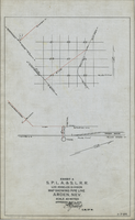
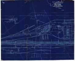
Map showing water pipeline in Arden, Nevada, May 4, 1913
Date
1913-05-04
Archival Collection
Description
'Exhibit A. S.P.L.A. & S.L.R.R. Los Angeles Division.' 'Approved May 4, 1913 [signed] E.M. Jessup, E.M. of W.' 'I-T-54.'
Image
Map of Las Vegas Valley Water District, April 16, 1953
Date
1953-04-16
Archival Collection
Description
'Exhibit A.' 'April 16, 1953. Dwg, No. I-128.' Accompanies: Bill of Sale - LA&SL L.S.D. Audit No. 5251, Contract Dept. No. 39722-3 (Box 25 Folder 80-12).
Image
Map showing water pipeline in Clark Street, Las Vegas, Nev., August 1919
Date
1919-08
Archival Collection
Description
'Exhibit A. L.A & S.L. R.R. Co., Los Angeles Division.' ' Las Vegas Land & Water Co., Las Vegas, Nev.' 'August 1919' (?) 'Approved [signed] C.F. Miller Div. Engr. '2-W-18.' Handwritten in lower left margin: 'Audit No.1987A. Expires 12/31/23.' Pipeline marked in yellow. Area of Las Vegas in map labeled as 'Clark's Las Vegas Townsite.' Scale: 1 in. = 400 ft.
Image