Search Results
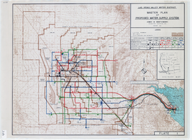
Topographic map of master plan for proposed water supply system for Las Vegas Valley Water District, August 1960
Date
1960-08
Description
Scale [ca. 1:63,360. 1 in. to approx. 1 mile]. Relief shown by contour lines. Includes inset location map of Water District. 'August 1960.' 'Plate 1.' Las Vegas Valley Water District
Image

Blueprint map showing proposed changes to water system, Las Vegas Land & Water Co., Las Vegas, Nevada, circa 1936
Date
1931 to 1941
Archival Collection
Description
'U.P.C. Co. #1799.31-T3-L3.'
Image
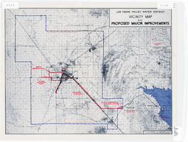
Map showing improvements made to the Las Vegas Valley Water District and vicinity, circa 1950
Date
1946 to 1954
Description
Relief shown by contour lines. Includes inset map showing the location of the Las Vegas Valley Water District Project. In lower left corner: 'Cole...O.' Boundary of Las Vegas Valley Water District marked in dark blue. Scale [ca. 1:126,720. 1 in. to approx. 2 miles
Image

Map showing second stage plan of development for Southern Nevada Water Project, March 1981
Date
1981-03
Description
'United States Department of the Interior, Bureau of Reclamation.' 'June 1976. Revised March 1981.' 'Map No. 952-300-203.' 'Exhibit I.' Includes inset location map for project area. Scale [ca. 1:126,720. 1 in. to approx. 2 miles] . United States Department of the Interior, Bureau of Reclamation
Image

Blueprint showing proposed pipeline for gravity water supply at Las Vegas, Nevada, February 16, 1905
Date
1905-02-16
Description
'Office of Chief Engineer, Los Angeles, Cal., Feb. 16, 1905.' '2-18-17' hand-printed in lower right corner. Proposed pipeline is printed in red. Scale [1:6,000]. 1 inch to 500 feet. San Pedro, Los Angeles & Salt Lake Railroad Company. Office of Chief Engineer
Image
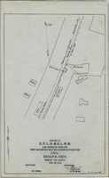
Map showing water connection for jail, Moapa, Nevada, December 28, 1914
Date
1914-12-28
Archival Collection
Description
'Exhibit A.' 'S.P.L.A.&.S.L.R.R., Los Angeles Division.' 'Approved, [signed] E.M. Jessup, E. M. of W.' 2-T-167A' hand-printed in lower right corner. Scale: 1 in. = 100 ft.
Image
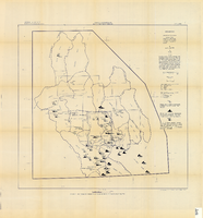
Map showing chemical diagrams representing quality of water in Clark and Nye counties, Nevada, 1963
Date
1963
Description
'T.E. Eakin, S.L. Schoff, and P. Cohen, 1963.' 'Department of the Interior, United States Geological Survey, TEI-833.' 'Prepared in cooperation with the U.S. Atomic Energy Commission.' Scale 1:500,000 (W 117°00´--W 115°00´/N 38°30´--N 36°30´). Originally published as figure 3 in Regional hydrology of a part of southern Nevada : a reconnaissance / by Thomas E. Eakin, Stuart L. Schoff, and Philip Cohen, published by the U.S. Geological Survey in 1963 as number 833 of the Trace elements investigation report.
Image
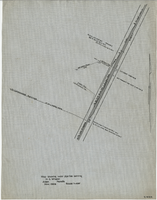
Map showing water pipeline serving H. C. Wheeler, Arden, Nevada, November 1929
Date
1929-11
Archival Collection
Description
Hand-drawn map. '2-W-214' hand-printed in lower right corner. Scale: 1" = 400'.
Image

Map showing plan for water quality management update for wastewater collection systems in the Las Vegas Valley, February 20, 1997
Date
1997-02-20
Description
'Plate 1. Source: Clark County Geographic Information Systems Central Repository. Comprehensive Planning, Advanced Planning Division. Feburary 20, 1997.' Scale [ca. 1:95, 040. 1 in.=approx. 1.5 miles]. Shows sewers, force mains, service area boundaries, watershed boundaries, and lift stations. Includes inset location map. Includes township and range grid. Clark County, Nevada, Comprehensive Planning, Advanced Planning Division.
Image
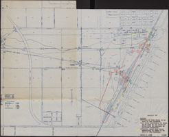
Map of water pipelines owned by or to be sold to the Las Vegas Valley Water District, March 1, 1953
Date
1953-03-01
Archival Collection
Description
Map shows portions of pipelines to be sold to the Las Vegas Valley Water District, pipelines connected to those to be sold to the District that will be retained by the railroad companies, and privately-owned pipelines connecting to those to be sold to the District. 'Exhibit D.' 'March 1, 1953.' 'I-128.' Las Vegas Land and Water Company?
Image