Search Results
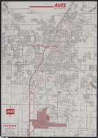
Map of metropolitan Las Vegas, Nevada, 1971
Text
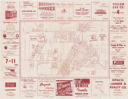
Map of the city of Las Vegas, 1953
Image
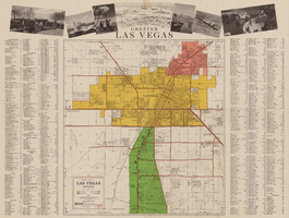
General map of Las Vegas, Nevada, circa 1957
distributed by Las Vegas Nevada Chamber of Commerce . Scale (ca. 1:39,000. 1 in. to approx. 3,250 ft.].
Text

Topographic map of Nevada-California, Las Vegas quadrangle, 1951
Image
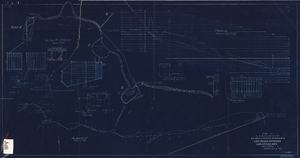
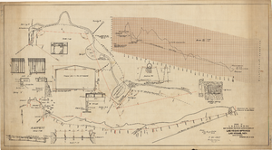
Blueprint showing proposed improvement of Las Vegas Springs, Las Vegas, Nevada, September 21, 1916
'Exhibit A'. 'Approved Sept. 21, 1916.' '2-N-1719' handwritten in lower right corner. 'W.E.J."--Lower left corner. "L-44 - 50 to 61. T-75 - 17 & 46"--Upper left corner. Includes discharge figures and plans for improvements to springs. Scale [ca. 1:240]. 1 in. to 20 feet. -- Scale [ca. 1:2,400]. 1 in. to 200 ft. Vertical scale [ca. 1:48]. 1 in. to 4 feet. -- Scale [ca. 1:4,800]. 1 in. to 100 feet. 1 map. Contents: Detail at springs -- Profile -- Alignment.
Image

Map showing location of the Las Vegas & Tonopah Railroad from Las Vegas to Bullfrog, Nevada, 1906
Image
Street map of the city of Las Vegas, North Las Vegas, the "Strip", 1955
Image

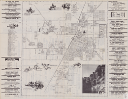
City map of Las Vegas, 1973
Color; 55 x 45 cm., on sheet 95 x 47 cm., folded to 24 x 10 cm. Panel title: Las Vegas city map. Copyright held by Cardinal Publishing Company. Relief shown by hachures. Includes illustrations and advertisements. Index, text, illustrations, advertisements, and map of "Lake Mead National Recreation Area, lower basin section" on verso. Original publisher: Cardinal Publishing Company.
Image
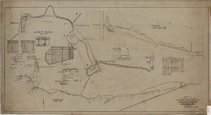
Map showing proposed improvements of Las Vegas Springs, Las Vegas, Nevada, January 26, 1918
'Exhibit A'. 'Approved Jan. 26, 1918.' Includes discharge figures and plans for improvements to springs for the municipal water system including diagrams of spillway openings, etc. Scale [ca. 1:1200] 1 in.=100 feet -- Scale [ca. 1:120] 1 in.=10 feet -- Scale [ca. 1:240] 1 in.=20 feet -- Scale [ca. 1:24] 1 in.=2 feet -- Scale [ca. 1:2400] 1 in.=200 feet. Vertical scale [ca. 1:48] 1 in.=4 feet -- Scale [ca. 1:12] 1 in.=1 foot.
Image
Map showing proposed improvement of Las Vegas Springs, Las Vegas, Nevada, September 21, 1916
'Exhibit A'. 'Approved Sept. 21, 1916.' 'W.E.J.'"--Lower left corner. 'L-44-50 to 61. T-75 - 17 & 46'--Upper left corner. Includes discharge figures and plans for improvements to springs Scale [ca. 1:240]. 1 in. to 20 feet. -- Scale [ca. 1:2,400]. 1 in. to 200 ft. Vertical scale [ca. 1:48]. 1 in. to 4 feet. -- Scale [ca. 1:4,800]. 1 in. to 100 feet. Library's copy has "Proposed layout" written on it in pencil near lower center and other markings in red. Contents: Detail at springs -- Profile -- Alignment.
Image