Search Results

Map showing configuration of potentiometric surfaces in Paleozoic and Cenozoic aquifers in the area between the Las Vegas Valley and the Amargosa Desert, Nevada, 1963
Date
Description
Image
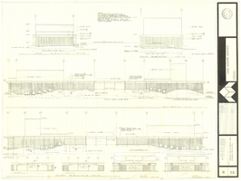
Architectural drawing of concert hall and drama theater, University of Nevada, Las Vegas, exterior elevations, November 5, 1969
Date
Archival Collection
Description
Exterior elevations for the concert hall and drama theater on the University of Nevada, Las Vegas campus, including a connecting courtyard. These buildings would become the Artemus W. Ham Concert Hall and the Judy Bayley Theatre. Sheet 6 of 35. "Drawn by G.T. Checked by K.D. Job number 6828. Scale 1/16" = 1'-0". Date Nov. 5, 1969"
Site Name: University of Nevada, Las Vegas
Address: 4505 S. Maryland Parkway
Image

Blueprint map showing proposed new 12" well and pipe line changes at water springs, Las Vegas, Nevada, circa 1920
Date
Archival Collection
Description
Image
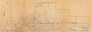
Map showing location of leased properties proposed to be sold to the Las Vegas Land and Water Company, October 2, 1952
Date
Archival Collection
Description
Image
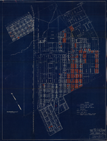
Map showing general plan for the district boundary of Lateral Sanitary Sewer District No. 1, Las Vegas, Nevada, circa 1928
Date
Description
Image

Map showing general geology and areas of artesian flow of the Las Vegas, Pahrump, and Indian Spring Valleys, Clark and Nye Counties, Nevada, 1946
Date
Description
Image
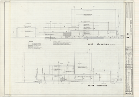
Architectural drawings of Fine Arts Building, University of Nevada Southern Regional Branch, Las Vegas, Nevada, east and north exterior elevations, July 15, 1963
Date
Archival Collection
Description
East and north exterior elevations of the Fine Arts Building (later to become the Judy Bayley Theatre) at the University of Nevada Southern Regional Branch, Las Vegas, Nevada (later University of Nevada, Las Vegas). Scale: 1/8" = 1'-0". "Sheet A-9 of 26." "Drawn: JM. Checked: JBM. Date 10 July 63. Submittal dates: preliminary 12-7-62; intermediate 3-17-63; final 7-15-63." "Bolt , Beranek and Newman Inc., consultants in acoustics. D'autremont-Helms & Assoc., consulting mechanical engineers. Helin Engineering Co., electrical engineers." "Fund code no. 82301." "State of Nevada Planning Board, Carson City, Nevada."
Site Name: University of Nevada. Southern Regional Division
Address: 4505 S. Maryland Parkway
Image
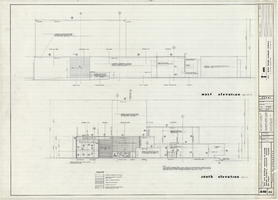
Architectural drawings of Fine Arts Building, University of Nevada Southern Regional Branch, Las Vegas, Nevada, west and south exterior elevations, July 15, 1963
Date
Archival Collection
Description
West and south exterior elevations of the Fine Arts Building (later to become the Judy Bayley Theatre) at the University of Nevada Southern Regional Branch, Las Vegas, Nevada (later University of Nevada, Las Vegas). Scale: 1/8" = 1'-0". "Sheet A-10 of 26." "Drawn: JM. Checked: JBM. Date 10 July 63. Submittal dates: preliminary 12-7-62; intermediate 3-17-63; final 7-15-63." "Bolt , Beranek and Newman Inc., consultants in acoustics. D'Autremont-Helms & Assoc., consulting mechanical engineers. Helin Engineering Co., electrical engineers." "Fund code no. 82301." "State of Nevada Planning Board, Carson City, Nevada."
Site Name: University of Nevada. Southern Regional Division
Address: 4505 S. Maryland Parkway
Image
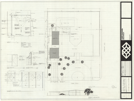
Architectural drawing of additions to the Mather residence, Las Vegas, Nevada, site plan, floor plan and details, October 14, 1975
Date
Archival Collection
Description
Site plan of the existing structure and additions to the Mather residence in Las Vegas, Nevada, including floor plans and details for a garage and additional bedroom. Included are the garage floor plan, drawings of the front exterior and entry elevations, and details for a skylight and the patio ceiling. "Date: 14 Oct. 1975, revisions: 15 Oct. 1975."
Site Name: Mather residence
Address: 2800 Cowan Circle;
Image
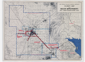
Map showing improvements made to the Las Vegas Valley Water District and vicinity under $8,700,000 bond issue,circa 1957
Date
Description
Image