Search Results

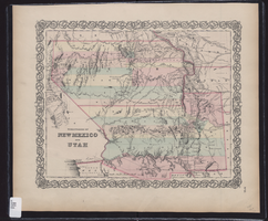
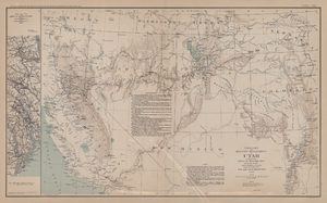
Map of California and Territories of New Mexico and Utah, 1862
Date
1862
Description
Scale [ca. 1:3,231,360. 1 in. to approx. 51 miles] (W 125°00--W 103°30/N 42°00--N 31°45) ; 1 map : hand col. ; 40 x 60 cm., on sheet 46 x 68 cm ; Relief indicated by hachures and spot heights ; Prime meridians: Greenwich and Washington, D.C ; Decorative border ; Hand colored ; Atlas p. numbers in upper margin: 58-59 ; Date est. from territorial borders and county configuration ; Shows natural features, locations of Indian tribes, proposed railroad routes, routes of explorers, trails, county boundaries and populated places ; Johnson and Ward
Image
Map showing the territories of New Mexico and Utah, 1855
Date
1855
Description
'Entered according to Act of Congress in the year 1855 by J.H. Colton & Co. in the Clerk's Office of the Dist. Court of the U.S. for the South'n. Dist. of New York.' Scale [ca. 1:4,752,000. 1 in. to approx. 75 miles] (W 120°--W 102°/N 43°--N 32°). Shows natural features, and populated places, wagon route, proposed railroad routes and explorers' routes. Relief shown by hachures. Prime meridians: Greenwich and Washington.Hand colored. Atlas p. number in lower-right margin: 51. Decorative border. J.H. Colton & Co.
Image
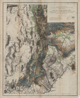
Map of Utah territory representing the extent of the irrigable, timber and pasture lands, 1878
Date
1878
Description
90 x 71 cm. Relief shown by hachures. In bottom margin: "Julius Bien, Lith." "Note. This map has been constructed from atlas sheets of the U.S. Geographical and Geological Survey of the Rocky Mountain Region with additional material taken from the maps of the U.S. Geographical Explorations and Surveys west of the 100th meridian, Lieut. Geo. M. Wheeler, Corps of Engineers, in charge ; the U.S. Geological Exploration of the 40th parallel, Clarence King, U.S. Geologist in charge ; and the U.S. Geologial and Geographical Survey of the Territories, F.V. Hayden, in charge." At head of title: Department of the Interior, U.S. Geographical and Geological Survey of the Rocky Mountain region, J.W. Powell in charge. Original publisher unknown.
Image
Map of territories of New Mexico and Utah, 1855
Date
1855
Description
29 x 36 cm. Shows natural features, and populated places, wagon route, proposed railroad routes and explorers' routes. Relief shown by hachures. Prime meridians: Greenwich and Washington. "Entered according to act of Congress in the year 1855 by J.H. Colton & Co in the Clerk's Office of the District Court of the U.S. for the Southern District of New York." Hand colored. Atlas p. number in lower-right margin: 51. Decorative border. The geographic region of Southwest is referred to as the New Southwest. Original publisher: J.H. Colton .
Image

Map of California and territories of New Mexico and Utah, circa 1861
Date
1856 to 1866
Description
40 x 60 cm. Relief shown by hachures and spot heights. Prime meridians: Greenwich and Washington. Atlas plate numbers 54 and 55 in the upper corners. Shows forts, trails, exploration routes, drainage, mail steamship routes, physical features, Indian tribes, and historic sites. The geographic region of Southwest is referred to as the New Southwest. Original publisher: Johnson .
Image
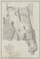
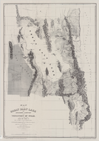
Map of the Great Salt Lake and adjacent country in the territory of Utah, 1850
Date
1849 to 1850
Description
108 x 75 cm. Map part hand colored. Relief shown by hachures and depths shown by soundings. Accompanies U.S. Army. Corps of Topographical Engineers. Exploration and survey of the valley of the Great Salt Lake of Utah. "Map of the Great Salt Lake and adjacent country in the Territory of Utah. Surveyed in 1849 and 1850, under the orders of Col. J. J. Abert, Chief of the Topographical Bureau, by Capt. Howard Stansbury of the Corps of Topographical Engineers, aided by Lieut. J. W. Gunnison Corps Topographical Engineers and Albet Carrington. Drawn by Lieut. Gunnison and Charles Preuss. Ackerman lith 379 Broadway N. Y." Original publisher: Ackerman Lith. Scale: 1:240,000.
Image
Map of territory and military department of Utah, 1860
Date
1860
Description
Compiled in the Bureau of Topographical Engineers of the War Department. Chiefly for Military purposes under the authority of Honorable J.B. Floyd, Secretary of War, 1860. 42 x 69 cm. Shows towns, wagon roads, explorers' routes, railroads, forts, etc., approx. from Albuquerque, N.M. to Fort Lane, Or. and from Fort Laramie, Wyo. to Los Angeles, Calif. "Corrections and additions in reference to railroads in California, etc., were made in January, 1862 ..." "The new military posts at Fort Bidwell, ... located from a map loaned ... January 16, 1866." "Atlas to accompany the official records of the Union and Confederate armies, 1861-1865. Plate CXX."--Upper margin. Atlas published by the Washington Government Printing Office in 1891-95. Relief shown by hachures. "Julius Bien & Co. Lith. N.Y." Includes text and list of authorities. Inset: March routes of Army of the Tennessee from Savannah, Ga., to Columbia, S.C., 1865, accompanying the report of Maj. Gen O.O. Howard, U.S. Army, series I, vol. XLVII, part I. Includes bibliographical references. Washington Territory is shown prior to becoming Washington state. The geographic region of Southwest is referred to as the New Southwest. Original publisher: Govt. Print. Off..
Image
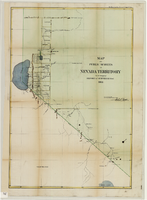
Map of public surveys in Nevada Territory to accompany report of Surveyor General, October 1, 1862
Date
1862-10-01
Description
'Surveyor Generals Office. San Francisco California October 1st 1862. [signed] E.F. Beale, U.S. Surv. Genl. Nevada Terry.' In upper right corner: 'Ho. Reps. Ex. Doc. No. 1. 37th Cong. 3d. Sess.' Relief shown by hachures. Scale [1:253,440] 1 in. to 4 miles (W 120°08--W 118°40/N 39°45--N 38°00)
Image

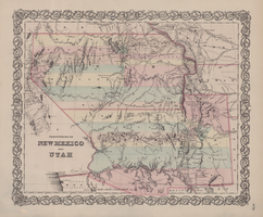
Map of California and territories of New Mexico and Utah, circa 1861
Date
1859 to 1862
Description
'Compiled, drawn, and engraved under the supervision of J.H. Colton and A.J. Johnson.' Relief shown by hachures and spot heights. Scale [ca. 1:3,041,280]. 1 in. to approx. 48 miles (W 124°--W 103°/N 42°--N 31°). Hand colored
Prime meridians: Greenwich and Washington
Plates 54 & 55 removed from Johnson's New illustrated family atlas of the world, with descriptions geographical, statistical and historical ... New York, 1862
Title page of atlas.
Prime meridians: Greenwich and Washington
Plates 54 & 55 removed from Johnson's New illustrated family atlas of the world, with descriptions geographical, statistical and historical ... New York, 1862
Title page of atlas.
Image
Map of the Great Salt Lake and adjacent country in the territory of Utah, 1852
Date
1852
Description
85 x 58 cm. "Available from the University of Utah Press, Salt Lake City, Utah 84112." Relief shown by hachures and spot heights; depths shown by soundings. "Scale 1:240,000"--inapplicable due to reproduction. Originally published to accompany Stansbury's report, Exploration and survey of the valley of the Great Salt Lake of Utah published in 1852 for the United States Army's Corps of Topographical Engineers. Includes text. Original publisher: University of Utah Press, Scale 1:240,000.
Image